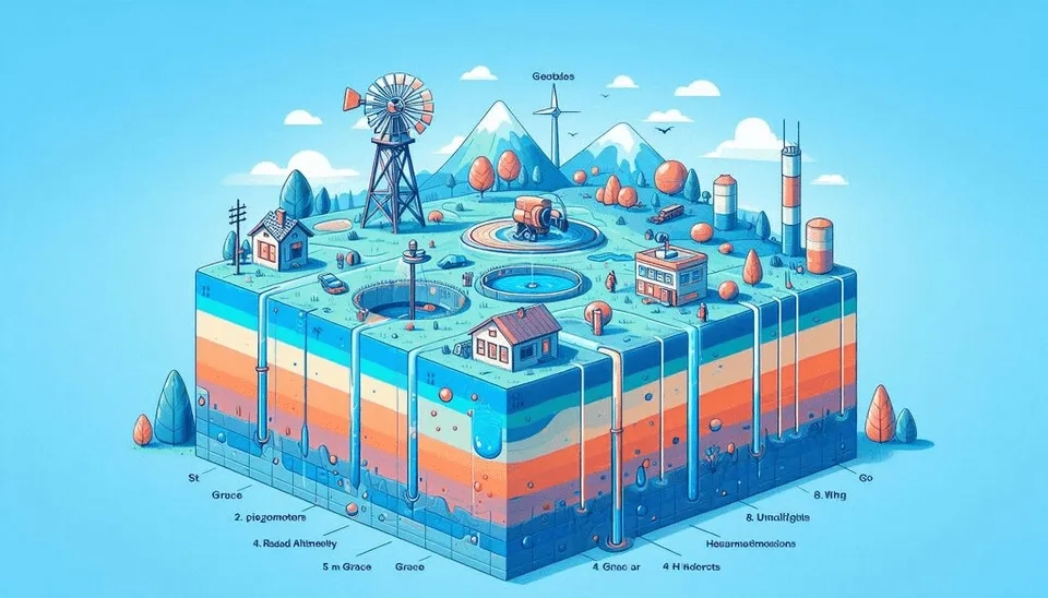
Imagine a world without fresh water for a moment! A world free of animals and plants and even humans! This is where the continuation of the current trend and excessive consumption of groundwater can bring us closer to it. How can we find out about this trend? The answer is groundwater monitoring!
According to the U.S. Geological Survey report, only 2.5% of the earth's water is freshwater, of which 68.7% is in glaciers and ice caps and is mostly not accessible and usable, and the other 30.1% is in groundwater (USGS, 1993). However, the Geological Survey presents in another report that during the years 1900-2008, almost 1000 cubic kilometers of groundwater in the United States were reduced, and the main reduction is in recent decades. However, the rate of groundwater depletion in most parts of the United States and other countries is not well measured and recorded, which requires quantitative monitoring of groundwater (USGS, 2018).
Table. Insights into 8 Practical Methods for Groundwater Quantity Monitoring
Method | Applications | Advantages | Disadvantages |
Set of piezometers or wells | Regional | Direct and accurate High spatial resolution | Expensive Time-consuming |
GRACE and GRACE-FO | Global | The whole sum of water storage changes | Need external datasets Limited spatial and temporal resolution Uncertainty |
Radar Altimetry | Global and Regional | Global availability | Coarse temporal resolution |
Thermal Infrared Images | Regional | Relationship with surface conditions | Actual spatial resolution |
InSAR Observations | Regional | High-resolution information | Wrong displacement detecting |
GNSS | Global and Regional | Global availability | Wrong displacement detecting |
Remote sensing-proxy measurements | Global and Regional | High spatial resolution | Indirect measurement Uncertainty |
Hydrological- water resources models | Regional | Simulate physical processes | Need calibration |
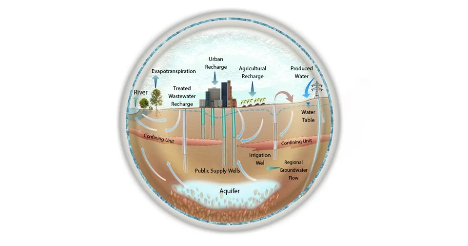
The wide range of aquifers and users of groundwater (agricultural, industrial, and urban users) has made it difficult to obtain data related to groundwater consumption in a spatial and temporal resolution, and attribute changes to human and natural factors. Quantitative and qualitative monitoring of groundwater systems in response to extensive natural, climatic, and human changes is essential for developing management strategies and predicting their future conditions. Therefore, many efforts have been made for a deeper understanding and continuous monitoring of groundwater using hydrogeological, geophysical, geostatistical, remote sensing, and applied research tools (Lee et al., 2016). Despite the progress made, there are gaps in the spatial and temporal analysis of groundwater, which has made the groundwater monitoring methods more important. As a result, it is necessary to know the practical methods in the quantitative analysis of groundwater and to identify the key challenges and promising strategies by using groundwater monitoring methods.
1. Groundwater Quantity
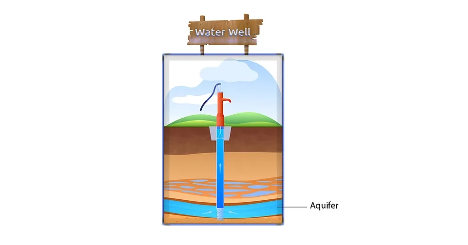
In general, groundwater monitoring can be examined from two qualitative and quantitative points of view, and here we are dealing with monitoring of groundwater quantity. Groundwater can be found in layered sedimentary aquifers, hard rock aquifers, and karst aquifers with large interconnected cavities. Depending on the location and type of aquifer, a groundwater system can range in size from 10 to 105 square kilometers. Groundwater consumption is done through a large and increasing number of wells, most of which are not measured or reported (Lall et al., 2020).
The lack of information about deep aquifers has caused many groundwater assessment models to focus on shallow aquifers. However, the majority of large-scale agricultural or industrial groundwater extraction takes place from deep aquifer layers because deeper wells and aquifers are less susceptible to climate change and pollution and are more reliable sources. Deeper underground aquifers have been declining worldwide, and this trend has intensified in the 21st century (Konikow, 2013). The result of excessive groundwater extraction can be revealed quickly or over decades through phenomena such as subsidence. Therefore, researchers have tried to estimate the spatial distribution rates of groundwater depletion using satellite gravity data, water balance models, and other tools.
2. Groundwater Monitoring Approaches
Today, several groundwater monitoring approaches are used all over the world, which are divided into three main categories: In situ observations, space‑based observations, and groundwater hydrology models, which are explained below:
2.1. In Situ Observation Networks
In situ, monitoring of groundwater quantity projects are implemented in a set of piezometers or wells that obtain spatial and temporal information about the quality and levels of groundwater using field data. These networks are the main source of information needed to make inferences about the hydrological behavior of groundwater (Bhat, 2015). In the in situ groundwater monitoring method, we use tools such as acoustic televiewers, manual water level measurements, and pressure transducers to obtain significant information about lithology and quantitative and qualitative characteristics of groundwater.
Groundwater data collected with acceptable spatial and temporal resolution are useful for building numerical models that enable the simulation of groundwater levels and quality. Currently, in situ groundwater monitoring networks have been set up in several parts of the world to measure the level and quality of groundwater at a regional level. Processing and display of this information is done in Geographic Information Systems (GIS) (Nas and Berktay, 2010).
In many areas, management and assessment of water resources is difficult due to limited groundwater monitoring. To overcome this challenge, the International Groundwater Resources Assessment Center (IGRAC) of the United Nations Educational, Scientific and Cultural Organization (UNESCO) established the Global Groundwater Monitoring Network (GGMN). This network aims to facilitate access and update information on quantitative and qualitative groundwater status with the aim of sustainable management (Escareño, 2022).
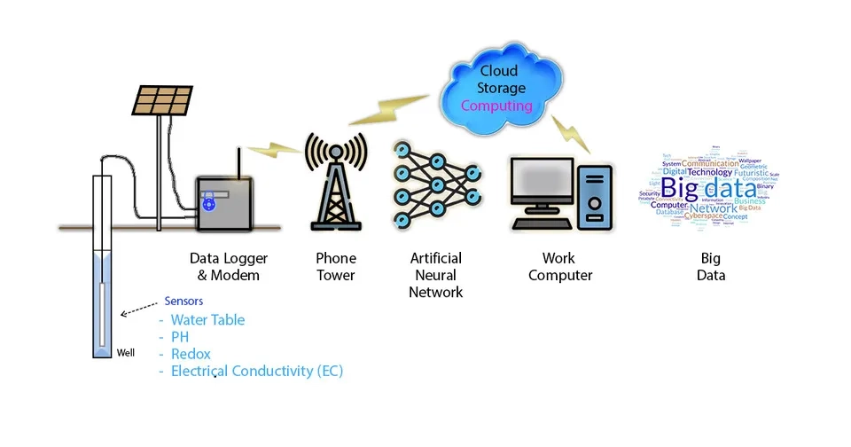
In situ measurement methods, such as groundwater well monitoring, face challenges such as diverse and heterogeneous geology, and heterogeneity caused by soil type, texture, and aquifer structure. Solving these challenges requires abundant in situ data. Even in places with abundant in situ data, there are challenges in aggregating, integrating, and interpreting observations. But in general, for regions without field data, there may be no information about groundwater depletion and monitoring (Adams, 2022).
2.2. Space‑Based Observation Techniques
The limitations of in situ methods and the development of technology have led to the establishment of new groundwater monitoring methods. The methods based on satellite and remote sensing can monitor groundwater on a local and global scale and have met with the favor of researchers (Jha et al., 2007). Here we introduce satellite-based and remote sensing techniques that provide valuable information for groundwater research.
2.2.1. GRACE and GRACE-FO
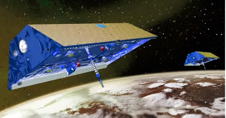
Gravity Recovery and Climate Experiment (GRACE) and GRACE Follow-On are the first satellite missions to provide valuable information on time-variable terrestrial water storage. Terrestrial water storage includes all components of water on and below the surface of the earth, soil moisture, surface water (swamps, rivers, lakes), snow water, and canopy water. GRACE satellites measure small changes in the Earth's gravity field caused by mass changes in the hydrosphere, atmosphere, biosphere, oceans, and mass changes within the solid Earth. Since atmospheric and oceanic contributions are removed during GRACE data processing, GRACE mainly reflects groundwater storage (Tapley, 2004).
2.2.2. Radar Altimetry
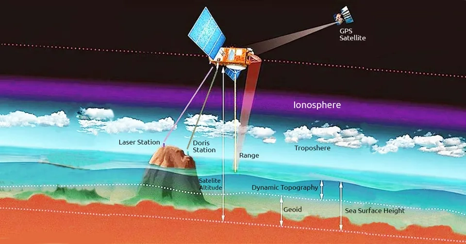
Radar altimetry is another tool for quantitative monitoring of groundwater. Radar altimetry was originally developed to determine ocean topography by measuring the distance between the Earth's surface and a sensor on a satellite, but today it is used to monitor inland waters. Time series of water levels obtained from altimetry can be used to identify the signature of climate variability and extreme weather events (Cretaux et al., 2017). The main strength of radar altimetry is the availability of its data on a global scale over a long period of time, starting in 1991 with the launch of ERS-1 (Pfefer et al., 2014).
2.2.3. Thermal Infrared Images
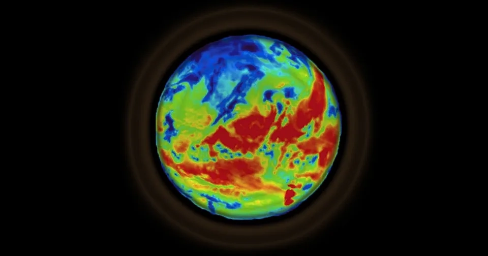
Thermal infrared images measure the temperature of the earth's surface and thus extract indirect information about the condition of groundwater. This information is obtained from thermal anomalies where the surface temperature is detected to be higher or lower than the surrounding temperature. However, in cases where the anomaly temperature difference is large (between 5 and 10 degrees Celsius), the interpretation of the results and the origin of the anomalies will face challenges and errors. The sharp difference in abnormal temperature is mainly caused by factors such as solar radiation, local topography, physical and chemical properties of the surface, geothermal heat flow, the presence of vegetation, and local weather conditions. However, in arid and semi-arid areas, using night infrared images, it can reduce the effect of error factors and extract more accurate information about the condition of groundwater (Lopez, 2016).
2.2.4. InSAR Observations
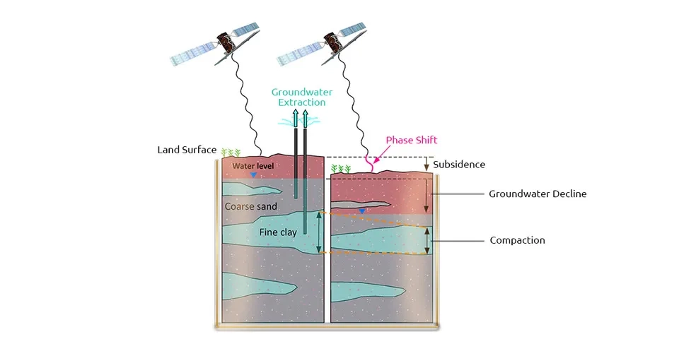
One of the most important applications of InSAR (Interferometric synthetic aperture radar) data is its ability to retrieve information about groundwater storage indirectly from land deformation. Landform changes are detected through space-based radar sensors, such as ERS, RADARSAT, ENVISAT, ALOS, and Sentinel-1, in which the conventional InSAR, the persistent scatterer interferometry, and the coherence change detection techniques are used. InSAR studies show that the observed subsidence is caused by groundwater depletion, while land uplift is associated with aquifer recharge and increased groundwater storage (Castellazzi and Schmid, 2021).
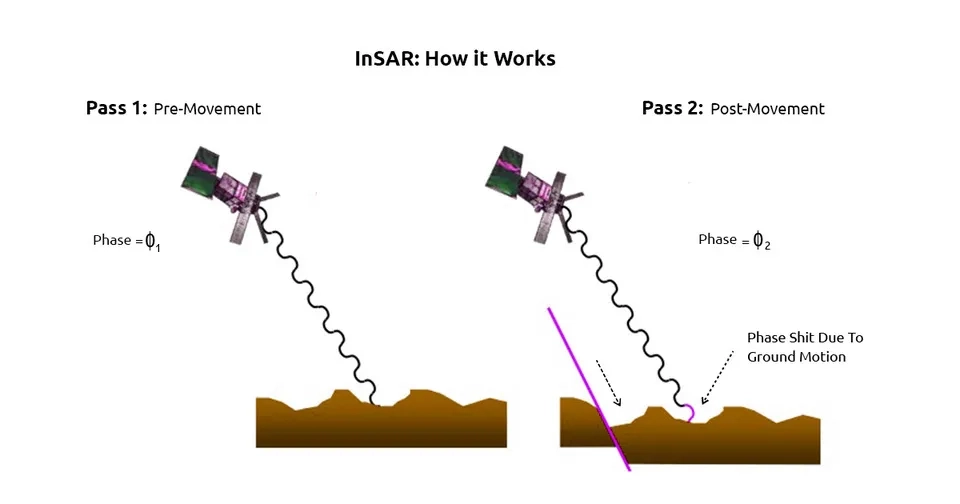
Based on this, unconventional changes in the shape of the earth through processes such as clay content on the surface, climate, and land use change cause errors in the measurement of groundwater. Nevertheless, compaction measurements and land subsidence detection from InSAR techniques have the potential to provide high-resolution information about aquifer dynamics. Also, InSAR extracts groundwater information from small aquifers at a local scale, while GRACE estimates groundwater changes only for very large aquifers, therefore, GRACE and InSAR are complementary (Castellazzi et al., 2016).
2.2.5. GNSS
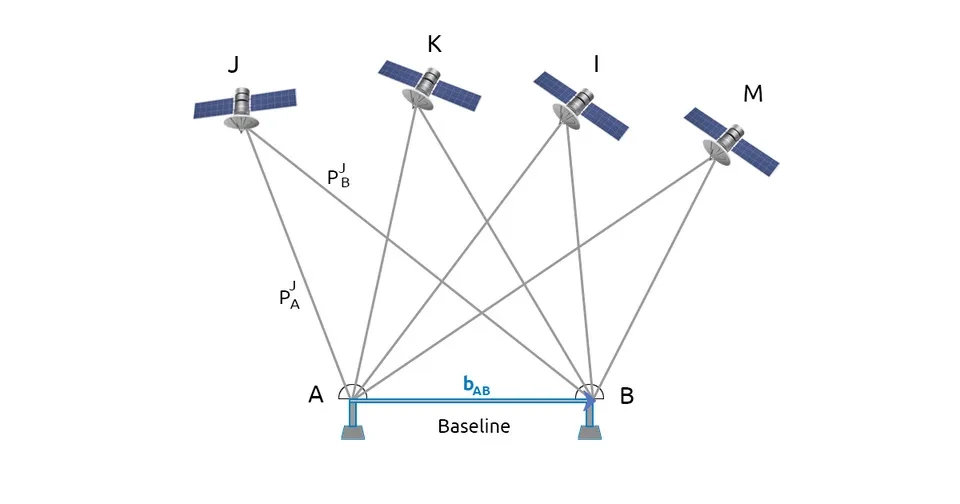
GNSS (Global Navigation Satellite System) is a space-based measurement technology that uses navigation satellites for highly accurate positioning. GNSS consists of a wide range of satellite-based positioning systems, one of which is the US GPS. The stations of the global satellite system can measure the vertical movements of the earth's surface in a point-wise, continuous, and precise manner and predict the depletion or filling of underground water. In the past decades, GNSS stations have spread all over the world, each of which can be used to monitor groundwater. Most of these stations are concentrated in the United States, Japan, Europe, and other strategic areas. Dense networks of GNSS stations enable the measurement of vertical deformations at high spatial resolution to monitor regional changes in groundwater. GNSS time series can be combined with other groundwater monitoring methods such as GRACE and InSAR to complement point-based measurements of surface deformation (White et al., 2022).
2.2.6. Remote Sensing for Proxy Measurements
In addition to the direct methods of measuring the volume or level of groundwater, remote sensing methods can indirectly provide information on the quantitative status of groundwater through the evaluation of proxies such as soil moisture, evaporation, and vegetation. This is because groundwater close to the surface of the earth directly or indirectly affects the vegetation and soil moisture, especially in dry and high infiltration areas (Hartmann et al., 2020). For example, in an arid region with low surface water and precipitation, the presence of agriculture, the greenness of vegetation, and high soil moisture provide evidence for the use of groundwater resources. Since optical remote sensing methods usually have a relatively high spatial resolution, assessment methods based on them can help identify groundwater use at a local scale. Furthermore, several techniques have been developed using visible, near-infrared, and thermal bands of Landsat and Sentinel-2 in order to infer evapotranspiration and soil moisture from space. Landsat-based methods for measuring evapotranspiration can be used to estimate groundwater consumption in an area where there are no known surface water sources. However, the presence of surface water in an area can make the analysis of this approach challenging (Chen and Hu, 2004).
2.3. Groundwater Hydrology Models
Groundwater monitoring and estimation can also be obtained from hydrological models. Hydrological models have the ability to numerically simulate the physical processes involved in groundwater storage at different spatial and temporal scales and are made up of mathematical equations as realistic as possible, which helps to better understand the groundwater cycle. Hydrological models can be classified into two categories: 1) land surface models, and 2) hydrological and water resources models. Hydrological and water resources models, unlike land surface models, have the ability to simulate and monitor groundwater and human harvesting. These models need calibration, which can generally be calibrated through in situ observations and ensure their performance (Springer et al., 2023).
4. Conclusion
The excessive consumption of groundwater and its negative consequences have caused groundwater quantity monitoring to be considered in advance. Several approaches have been presented for the quantitative monitoring of groundwater, and in this article, we discussed three practical groundwater monitoring approaches (1, 2, and 3) on a wide temporal and spatial scale. It is also possible to use the integration of the 3 mentioned approaches to achieve more accurate and reliable results. More accurate groundwater monitoring will bring more sustainable and successful solutions and strategies to protect valuable underground resources. This goal cannot be reached unless the all-out efforts of individuals, communities, governments, and international organizations.
