cloud microphysics and precipitation influenced by aerosols
Share
Have you ever thought about how clouds decide to start raining? Imagine they are a balloon that keeps water until it explodes and precipitation will happen. Is not it fantastic? So let's explore the relationship between precipitation and clouds, which influence our weather.
Although microphysics plays a significant role in weather and climate models, it is not well represented in the models that are currently used. However, cloud-affected data assimilation is discussed; an important distinction is whether it is intended to improve the analysis of temperature and moisture in the presence of clouds, e.g., the free atmosphere above the cloudtop, or to improve the analysis of clouds and precipitation and consequently, temperature and moisture within clouds.
One of the crucial components of the hydrologic cycle is the cloud, which saves and transfers the water between the ground and atmosphere (Wacker et al., 2009), and a key component in precipitation distribution is the cloud (Otkin, 2010; Peng et al., 2014). According to Lee et al. (2018), the precipitation rate is higher in the summer than in the winter due to the impact of the monsoon system on the city. In this paper, the aerosol's affection and seven effective cloud properties on precipitation have been considered due to their mission in precipitation events.
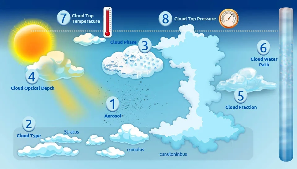
Fig. 1. The eight key cloud microphysics and precipitation effective factors, including Aerosols, their influence, and measurement units.
Table 1. Cloud microphysical properties related to precipitation.
Precipitation Effective Factors
Affection type
Aerosol
Direct affection
Cloud Type
The highest level has the most effect
Cloud Phase
The warm liquid water phase has the most direct effect
1. Aerosols Impact on Could Microphysics and Precipitation
There is strong scientific evidence and broad agreement that aerosol radiative effects can microphysically increase cloud droplet number and decrease their size, which thereby makes the precipitation droplets. However, still the entire aerosol impact on precipitation over scales is unclear. Furthermore, common changes to large-scale precipitation patterns, like the intertropical convergence zone, is caused by aerosol radiative (Stier et al., 2024).
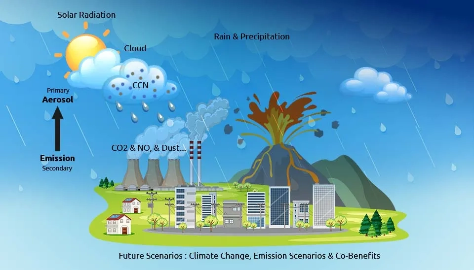
Fig. 2. Illustration of Aerosol emission sources, their role as CCN in cloud microphysics, and effect on rain and precipitation.
Aerosols play an important role in precipitation properties, and influence human life and local climate. Aerosols are an essential element of cloud formation and a vital regulator of the radiation budget, which impacts the precipitation intensity, frequency, area, timing and geographical dispersion (Zhao et al., 2024).
According to the next figure, an increment of hygroscopic aerosols increases the amount of precipitation when there is a sufficient influx of water vapor. However, cloud droplets struggle to expand when there is an insufficient influx of water vapor, which is a sign of light precipitation. Therefore, the precipitation amount will decrease (Choobari, 2018).
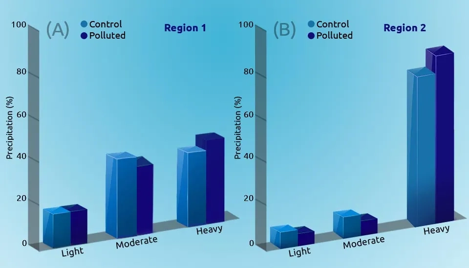
Precipitation amounts over the mountain area and flat region are examined to indicate that the aerosol impact on precipitation is related to the precipitation rate, considering three types of precipitation rate (light, moderate, and heavy) for the polluted and cleaned air (Fig. 2).
The following graphics confirm that during the heavy precipitation, an increase in aerosol amount leads to a dramatic growth but in moderate and light precipitation case, this relation becomes inverse:
Fig. 3. Aerosols increase heavy precipitation but reduce light/moderate rain percentages across mountain and flat regions.
Stier et al. suggested that the aerosol has an impact on both precipitation value and geographic distribution from the cloud size to the global scale. Previous studies have claimed that precipitation, cloudiness, and surface energy budgets are connected to large-scale regional and global changes in aerosol amounts (Kiehl and Briegleb, 1993; Kim et al., 2014; Ramanathan et al., 2005).
2. Cloud Type and Level
Cumulonimbus clouds are usually associated with precipitation and snow showers, and also hail and thunder, which frequently occur. On the other hand, cumulus and cumulonimbus clouds, which are not associated with orographic or frontal lifting events, indicate major atmospheric instability and surface heating from the ground up to the cloud tops .
Nimbostratus clouds are thick, dense, or stratocumulus clouds that produce regular rainfall or snow (NASA).
Mishra (2019) studied the linkage between cloud cover changes and precipitation extremes for 18 years using brightness temperature (Tb), and he found that light rainfall (<20 mm/day) occurs due to low-level clouds (Tb > 245 K). During this study, a correlation was found between increases in very deep convective, deep convective, and convective clouds and the top 20%, 10%, 5%, and 1% of heavy rainfall.
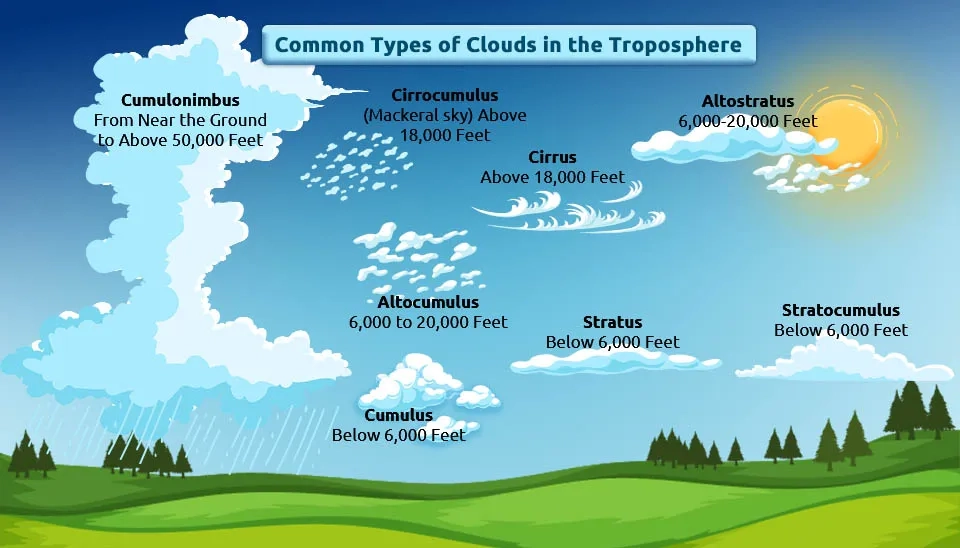
Fig. 4. Diagram showing tropospheric clouds categorized into low (Stratus), mid (Altostratus), and high (Cirrus) levels, with associated heights.
Tropospheric clouds influence the earth's climate in various ways. There are some reasons for the precipitation, which have a major impact on its distribution and quantity, as clouds are linked to the vertical air motion, which is convective, frontal, or cyclonic.
Many investigations about cloud types and precipitation have been employed, such as:
Liu et al. (2014) discovered that heavy precipitation could happen in the front of cumulonimbus clouds and near to the convective center over Huaihe River Basin.
Anderson (2015) also proved that precipitation is associated with three types of clouds in tropical regions: cumulus, shallow precipitation clouds, and deep convective clouds. He discovered that ISCCP methods tend to underestimate the stormy cloud types in these areas.
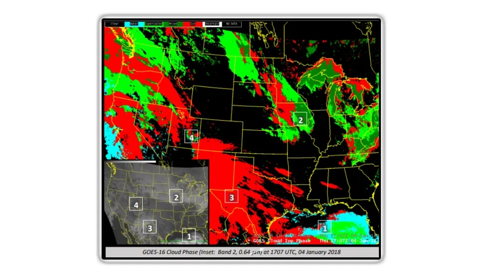
ZZ(Ice, Liquid, Mixed): Affecting Precipitation Distribution
The cloud-top composition has been defined with the baseline Cloud Phase product. There are four cloud phase types: (1) mixed-phase (liquid water and ice), (2) glaciated (ice), clouds with the (3) temperature above 273 K liquid water, or (4) under 273 K liquid water (supercooled) (NASA).
Fig. 5. Cloud phase overview, a key feature in cloud microphysics and precipitation studies.
3. Cloud Phase(Ice, Liquid, Mixed): Affecting Precipitation Distribution
Cyan cloud tops are composed of water droplets. The bright green represents the supercooled water droplets, while the darkest one indicates mixed-phase clouds. The red clouds represent glaciated clouds, and sometimes snow cover appears as unmoved clouds (NASA).
In most parts of the earth, the ice phase is an essential requirement for the production of precipitation (Mülmenstädt et al., 2015).
The cloud phase, which is considered a crucial cloud feature, has been investigated in previous studies on cloud properties. Due to the cloud phase variation, different results were discovered for the cloud radiative effect and precipitation properties (Fu and Liou, 1993; Mülmenstädt et al., 2015; Deetz et al., 2018).
The studies based on observation have found that warm water clouds are the main cause of precipitation distribution in tropical areas .
4. Cloud Optical Depth
This parameter is defined by the vertical optical thickness between the cloud’s top and bottom. In the visible spectrum, cloud optical depths are mostly wavelength independent. However, with the help of water absorption, they grow quickly in the infrared wavelength range (AMS).
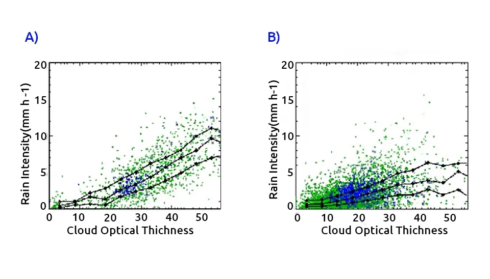
Kazuaki Kawamoto (2006) investigated the relationship between cloud properties such as cloud optical depth and precipitation over the Amazon basin. We found that since the cloud optical thickness increases, the amount of precipitation also increases.
Fig. 6. Cloud Optical Depth vs. Rain Intensity for (A) ice clouds and (B) overlapping clouds, showing a positive correlation.
The above figure shows the relationship between cloud optical thickness and precipitation in two different situations. The blue dots indicate a cloudy grid cell over the sea, while the green dots are over the land. According to this scatter plot, the correlation between precipitation intensity and cloud optical thickness is positive .
It is proven that during heavy precipitation, the cloud optical thickness increases significantly with rain rate; however, during weak precipitation, a significant increase in rain rate was observed due to significant changes in liquid water path and the effective radius of cloud droplets (Kobayashi and Masuda, 2009).
5. Cloud Fraction
The percentage of each pixel covered by clouds is recognized as the cloud fraction with the color range from blue (no clouds) to white (entirely cloudy) (NASA).
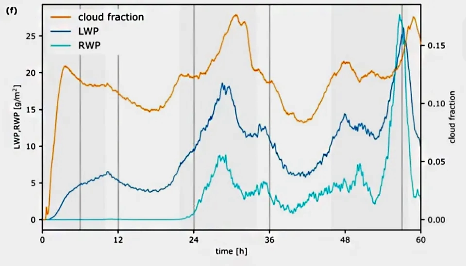
Fig. 7. Time series of Cloud Fraction, LWP, and RWP, illustrating their diurnal cycle and positive relationship with precipitation
The diurnal circle is represented by the darkened background, while the darker area is the nighttime (18-06 hours local time). The gray vertical lines show the time of image capture. At midnight UTC, all simulation leaves cloud-free conditions. The first ten hours are defined by The formation of tiny, disorganized cumuli and the beginning of the convection. Then, these non-precipitating clouds slowly bring the group together to form the bigger structure. The shortwave radiation’s diurnal cycle influences this pattern by heating, which stabilizes the zone for convection after the sunrise, makes the horizontal average LWP, and reduces the cloud fraction. The cloud structure grows quickly and starts to rain about 24 hours after the simulation began and over the sundown, precipitating convective cells, arranged along the cold pool and finished by the thin layer clouds, then dominating the second diurnal cycle.
In this way, the figure proves the positive correlation between the cloud fraction and precipitation.
Although there are many numerous factors, which affect cloud fraction transition, the studies illustrate that cloud fraction has an impact on precipitation ( Rapp, 2016).
In 2020, the anvil cloud fraction was considered by Jeevanjee and Zhou as an important Earth climate factor, and this sensitivity has a strong relationship between the evaporation and precipitation efficiency resolution-dependence.
Su et al. (2017) studied the precipitation rate in warm climates with the cloud cover, which results in the tightening of tropical ascent. They found that as temperature rises, a high cloud fraction increases over the deep tropics.
6. Cloud Water Path
During the precipitation event, there is a high correlation between rain liquid water with rain rate and cloud liquid water.
During the weak precipitation situation, rain, liquid water, and the height of organized clouds change slightly; they display various distributions (Zhang et al., 2020).
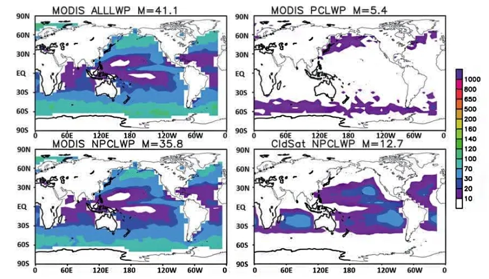
Fig. 8. Satellite-derived Cloud Liquid Water Path for different cloud phase and precipitation states.
This figure indicates that the precipitating cloud contribution is predicted to be around 10% of the cloud liquid water path in all situations, and retrieval is used over the ocean (Li et al., 2018).
The precipitation increases with ground elevation under 3000 m and decreases above 3000 m due to the ground height determination and water vapor, which have an impact on cloud distribution and precipitation. As low-level water vapor supply decreases from the southeast to the northwest, the cloud water path (CWP), precipitation, and precipitation efficiency (PE) in the mountain area are higher in comparison with others in the surrounding areas. Due to the great deal of water vapor, which transfers from the southeast in the summer, the precipitation, CWP, and PE have the highest amounts in the summer (Qi et al., 2022).
7. Cloud Top Temperature
Satellite infrared radiometers usually use cloud top temperature to determine the precipitation value. However, for shallow or warm clouds, these temperatures have a low coefficient with surface rainfall (So and Shin, 2018).
The precipitation is related to the various cloud top temperature stratiform or convective and its temperature. On the other hand, precipitation in clouds at a particular depth might be different depending on the composition of clouds, including cloud phase and distribution of cloud particles' sizes, which can be either water or ice. These variations can determine the differences between rainless and precipitation clouds (Rosenfeld, 2000).
According to Atlas and Bell (1992), cloud tops < 235 K and large-scale surface precipitation in the tropics are caused by cold cloud tops, which are actually a pair of the Cumulonimbus (Cb) clouds.
Cloud top temperature shows a negative correlation with aerosol index (AI), causing increasing over oceans and aerosol optical depth (AOT) over lands. For the mixed-phase clouds, precipitation rates have a positive correlation with AI, while liquid clouds show a negative correlation (Niu and Li, 2012).
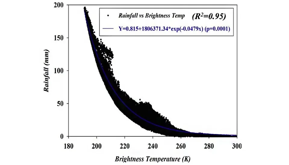
Fig. 9. Cloud Top Temperature vs. Precipitation scatter plot, crucial for Detailed Microphysics of Clouds and Precipitation studies.
According to this scatter plot, cloud tops (Tb < 20 K) cause the heavy rainfall (>60 mm/day). Moderate rainfall (<60 mm/day and >20 mm/day) is more likely to occur in medium clouds (>220 and <245 K), and light rainfall (<20 mm/day) occurs in low-level clouds (Tb > 245 K). Generally, there is a negative correlation between cloud temperature and precipitation, indicating that as the temperature increases, the amount of precipitation tends to decrease (Mishra, 2019).
8. Cloud Top Pressure
The lower pressure in the middle of the low-pressure system, rather than its surrounding area, causes wind movement toward the lower pressure area. Therefore, due to air rises, water vapor in the air expands, creating clouds and frequent precipitation (UCAR).
During the warm climate atmospheric pressure and density at the high cloud altitude decrease with cloud elevation.
Air is ascending constantly from the cloud based on the cloud top in cloudy updraft at the rate of M (kg m⁻² s⁻¹). Additionally, from Tb at the cloud based on Tt at the cloud top, the updraft's temperature falls (Atmospheric science):
In this formula, P is the cloud-base precipitation, Tb is the cloud-base temperature, and Pb is the cloud-base pressure. M stands for constant vertical mass. w (T, p) is the ratio of mixing saturation, which is
directly readable from a skew T log P diagram (atmospheric science).
The relationship between ice crystal accumulation, sublimation, deposition, and formation determines high clouds. Additionally, in warmer climates, the pressure dependencies of these processes can reduce high clouds. Therefore, the global warming-related change in the high cloud pressure level is important for high cloud area feedback (Onho et al., 2021).
Conclusion
Two-thirds of clouds cover our planet, and their macro- and microvariations could affect atmospheric radiative transport (Chen et al., 2019). Therefore, it is crucial to consider the cloud properties and their role in precipitation events and climate change.
According to this paper, some cloud microphysics and aerosols have an important direct and indirect impact on precipitation and for predicting precipitation, etc. In order to manage the water resources better, we need to consider them as an important role.
However, many studies investigated the relationship between clouds and precipitation, but to obtain clarified results and to create the specific equation for these relations, more analysis is suggested with each parameter's data considering the time and spatial resolution. Furthermore, given the significant influence of the aerosol effect on precipitation, we recommend further research on this crucial parameter.


Comments
No comments yet
Be the first to comment
Share your thoughts and start the conversation.