Abstract blue and white illustration of a winding river flowing under a bright full moon in a stylized landscape.
Share
The majority of the earth is submerged under water. But how much water does our planet have? Groundwater, surface water, soil water, and other elements such as ice, vegetation water, and snow make up the global terrestrial water storage. It is estimated to make up approximately groundwater (37.56 ± 16.57%), surface water (36.08 ± 9.89%), and soil water (26.36 ± 7.46%). (Wang et al., 2020).
Surface water resources are only a part of the water resources, but they are the most accessible to the human population, ecosystems, agriculture, industry, and societies across local, national, and global scales.
Over the past three decades, more than 162,000 Km2 water bodies previously thought of as permanent have proved not to be so; almost 90,000 Km2 have vanished altogether, and over 72,000 Km2 have transitioned from a permanent state to a seasonal state. During the same period, almost 213,000 Km2 new permanent water bodies came into existence; 29,000 Km2 of these used to be seasonally flooded but are now underwater all year round, while 184,000 Km2of permanent water formed in areas previously devoid of surface water (Pekel et al., 2016).
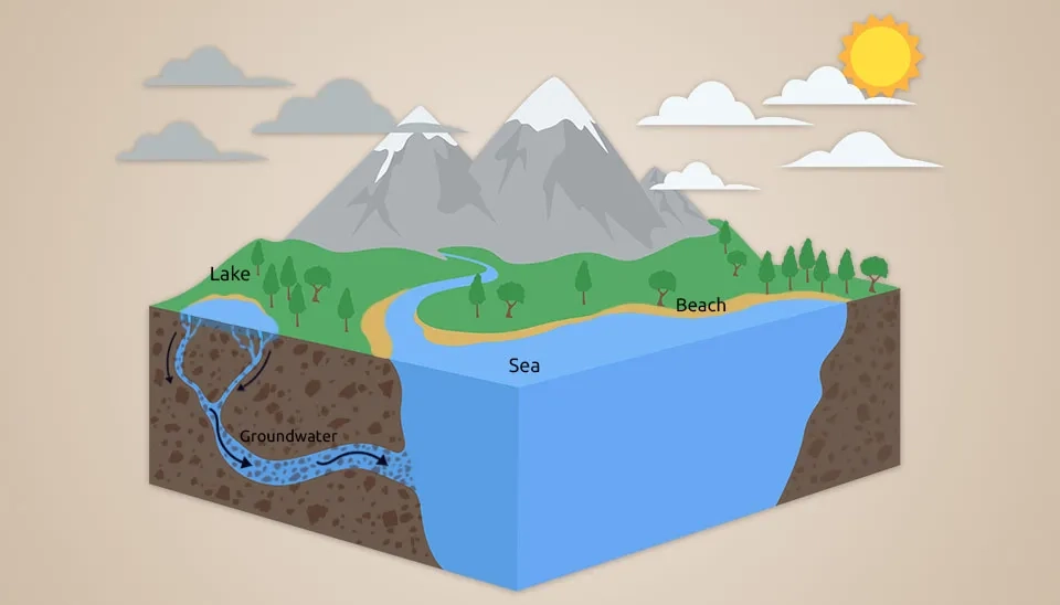
Surface water processes are a key component of the hydrological cycle. Surface water definition is any body of water found on the Earth’s surface, including both the saltwater in the ocean and the freshwater in lakes, dams, streams, reservoirs, and rivers, which is water that is open to the atmosphere. Components within surface water hydrology include precipitation and water runoff that feed bodies of surface water, while evaporation and infiltration of water into the ground cause water bodies to lose water (Beza et al., 2023). A branch of science that deals with surface water is called surface water hydrology. According to the definition of surface water hydrology, it is the study of moving water in rivers, open channels, and runoff flowing on the surface of the earth (
Vamshi et al., 2023
).
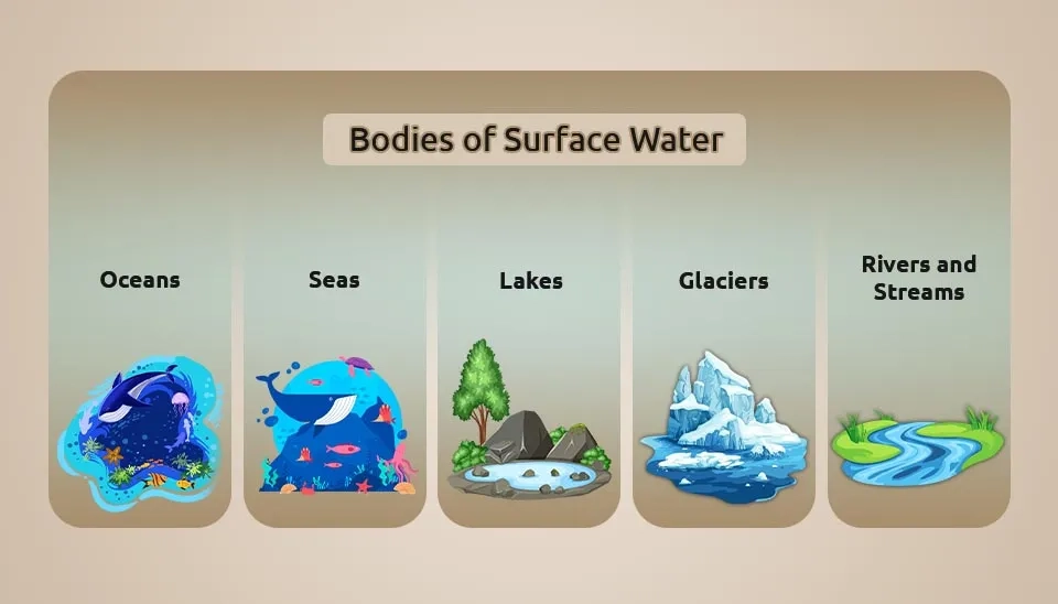
Fig. 1. Key types of surface water: oceans, seas, lakes, glaciers, and rivers and streams.
1. Surface Water Distribution
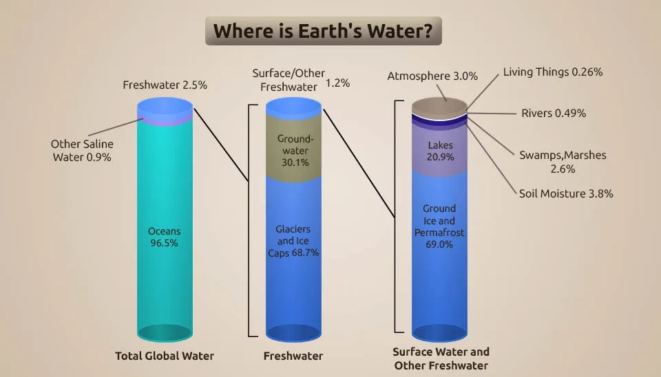
Only less than 3% of the surface water is fresh; the remaining is saline water, 96.5% of which is located in oceans. Of freshwater, about 68.7% resides in glaciers, 30.1% underground, and 1.2% is located in surface fresh water (USGS, 2018).
We know that most of the surface freshwater in the right bar is frozen, and 20.9% is in lakes. Rivers as surface water flows make up 0.49% of surface freshwater. Although rivers account for only a small amount of freshwater, this is where humans get a large portion of their water.
Fig. 2. Visual breakdown of where water is located on Earth, including oceans, glaciers, and lakes.
2. Bodies of Surface Water
Bodies of surface water are described as discrete and significant elements of surface water, such as oceans, seas, lakes, reservoirs, streams, rivers, or canals; parts of streams; or transitional water. By this definition, surface water bodies can take different forms, sizes, and shapes due to local physiographic factors. The most important factors are defined below:
2.1. Oceans
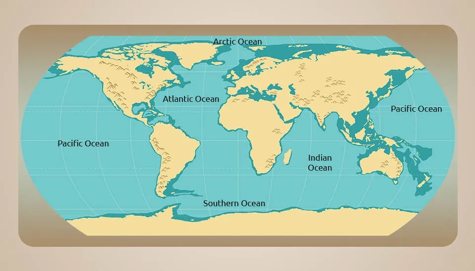
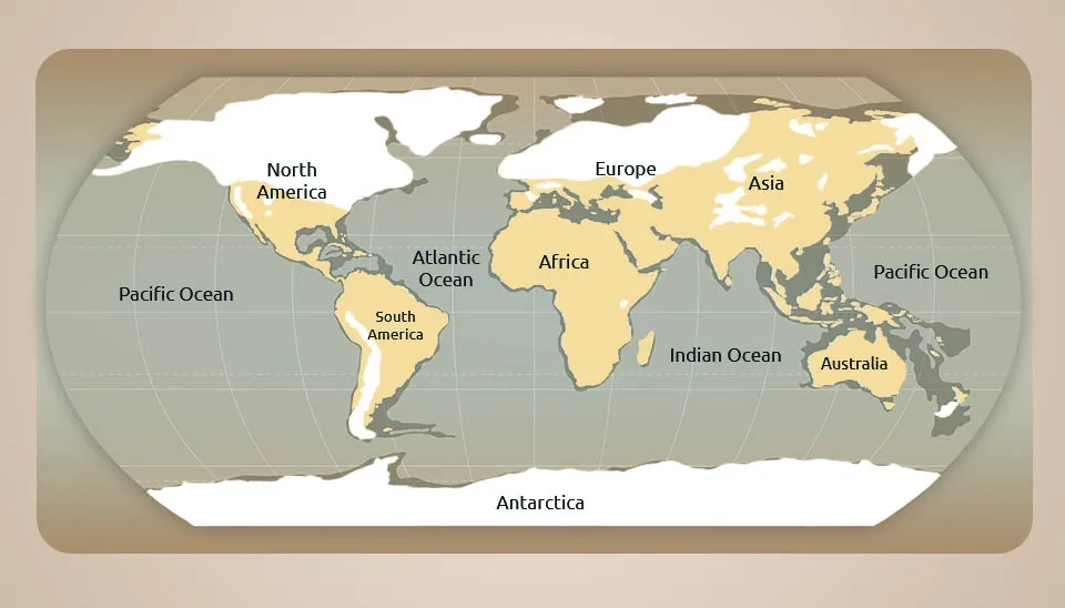
Oceans are the biggest bodies of saltwater on earth, which cover at least 71% of the surface of the earth. The entire marine saltwater that you see on Earth ultimately ends up in the world ocean. However, the way our continents are arranged makes it easier to differentiate between specific ocean basins. Although the ocean is one continuous body of water, oceanographers have divided it into five principal areas: the Pacific, Atlantic, Indian, Arctic, and Southern Oceans. The ocean makes all life on Earth possible and makes the planet appear blue when viewed from space. Oceans have a significant impact on the water cycle (USGS, 2022).
Fig. 3. Principal oceanic divisions: Pacific, Atlantic, Indian, Arctic, and Southern Oceans.
2.2. Seas
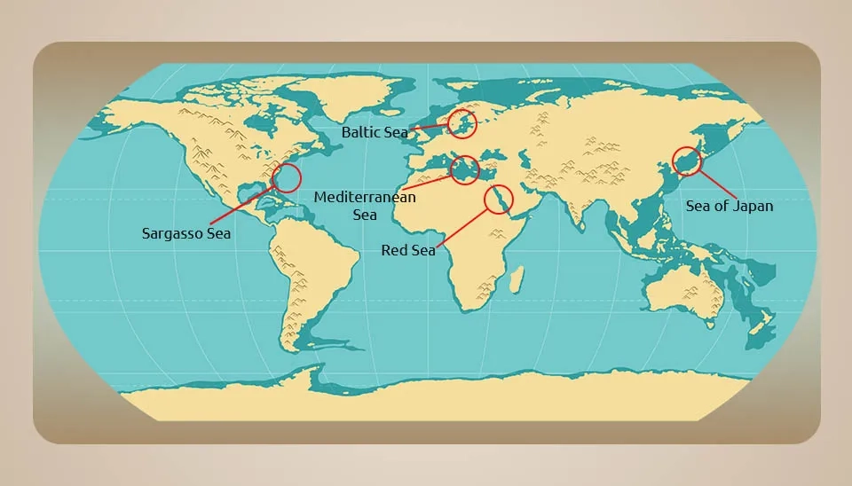
In general, a sea is defined as a portion of the ocean that is partly surrounded by land. The most common example of a sea is the Mediterranean Sea. We also have other popular ones like the South China Sea, the Caribbean Sea, and the Bering Sea. Most of these water bodies directly connect to the ocean. However, there are particular saline water bodies, and the Caspian Sea is an example of that. It also splits into smaller groups of gulfs, straits, and bays (Douglas, 1992).
Fig. 4. Exploring various seas around the globe, connecting to oceans or landlocked.
2.3. Lakes
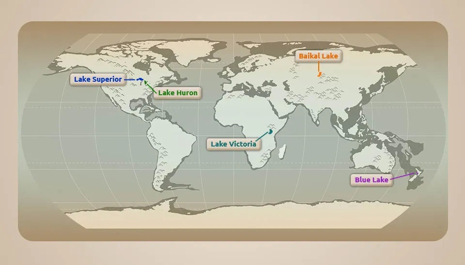
A lake is where surface-water runoff and groundwater seepage have accumulated in a low spot, relative to the surrounding countryside. These are inland bodies of water and are found either in freshwater or saltwater. Lakes are also enclosed by land and some even categorize the Caspian Sea as a lake. There is no precise difference between a lake and a pond. However, lakes can also be quite huge, like the Great Lakes of North America and Lake Baikal of Russia. Lakes are created from a lot of procedures, some of which are glacial erosion as well as volcanic eruption in addition to damming of rivers. A reservoir is the same thing as a lake in many peoples' minds. But, in fact, a reservoir is a manmade lake that is created when a dam is built on a river. River water backs up behind the dam creating a reservoir (USGS, 2018).
Fig. 5. Discovering major lakes around the globe and their geographical locations.
2.4. Rivers and Streams
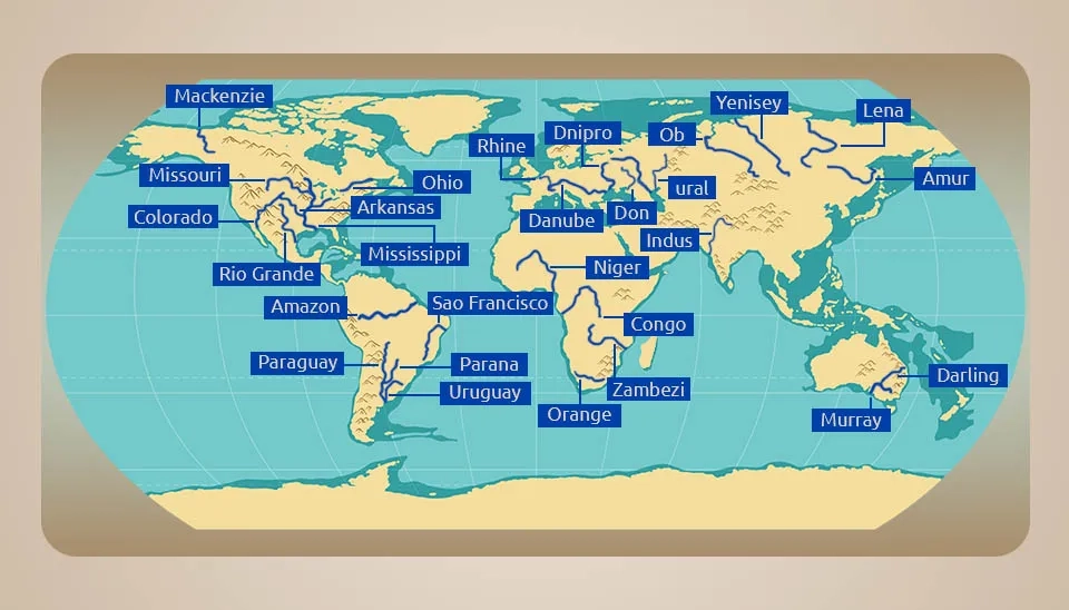
These are basically bodies of surface water flows. In other words, the water which flows on the earth’s surface creates rivers, streams, and creeks. Creeks as the smallest of the three, with streams being in the middle, and rivers being the largest. They consist of freshwater which ends up in the ocean through the constant flow of rivers and streams. Rivers flow through valleys in the landscape with ridges of higher land separating the valleys. The area of land between ridges that collects precipitation is a watershed or drainage basin. Most, but not all, precipitation that falls in a watershed runs off directly into rivers - part of it soaks into the ground to recharge groundwater aquifers. Rivers are quite an important source of water as well as energy. In addition to that, they are also used greatly for transportation purposes and as fishing grounds. River Nile in Africa is one of the longest rivers in the world in addition to the River Amazon in South America (USGS, 2018).
Fig. 6. Exploring the global network of rivers and streams across continents
2.5. Glaciers
Glaciers are frozen bodies of water. They are also a kind of water body only which moves slowly similar to frozen rivers. All the glaciers, ice caps, glacial ice, and all are millions of years old. They cover almost 10% of the earth’s land area and are sources of freshwater. The vast majority, almost 90 percent, of Earth's ice mass is in Antarctica, while the Greenland ice cap contains 10 percent of the total global ice mass. In many places, glaciers on Greenland reach the sea, and one estimate is that as much as 125 mi3 (517 km3) of ice "calves" into the ocean each year—one of Greenland's contributions to the global water cycle (USGS, 2019).
Fig. 7. Understanding the vast ice masses covering approximately 10% of Earth’s land
3. What Is Surface Water Used For ?
Surface water is a vital resource that supports a wide range of human activities and ecosystems. Surface water is used for different purposes, such as drinking, agriculture, industrial uses, electricity generation, etc. It is also the major source of freshwater for humans and animals. Surface water, such as rivers, when flowing through a high gradient slope, can generate electricity, which is done by constructing dams across the valleys. Surface waters and their associated ecosystems provide habitat to many plant and animal species. Because surface waters are on the land surface, they are easily developed for use (Uddin et al., 2021).
4. What Affects Surface Water Availability?
Surface water availability refers to the amount of surface water that is present in a particular area at a specific time and can be used for various purposes. Surface water availability can be affected by different factors such as
4.1. Rate of Precipitation
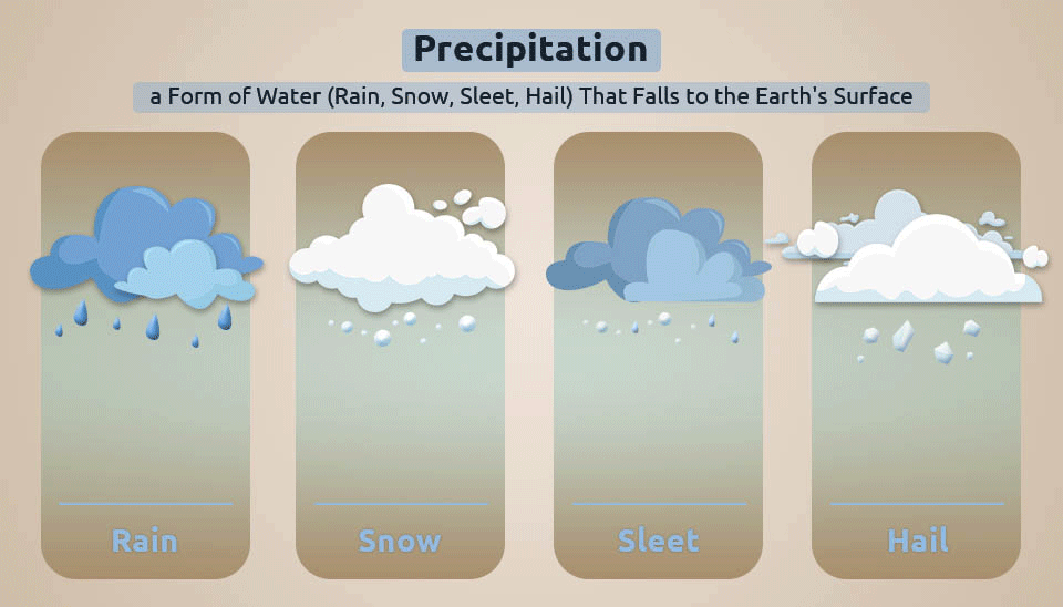
Precipitation is water released from clouds in the form of rain, freezing rain, sleet, snow, or hail. Precipitation is the main way atmospheric water returns to the surface of the Earth. Most precipitation falls as rain. The amount and distribution of precipitation in an area directly impact surface water availability. Areas with high precipitation tend to have more surface water resources, while low precipitation rates can lead to experiencing water scarcity (Rohli and Li, 2021).
Fig. 8. Understanding precipitation: water falling to Earth's surface in different forms.
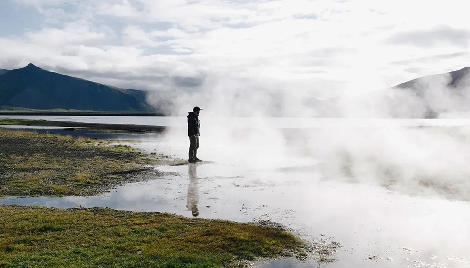
4.2. Rate of Evaporation
Evaporation is the process that changes liquid water to water vapor. A high evaporation rate leads to the loss of water into the atmosphere, thereby affecting the amount of surface water. Higher temperatures and insolation could increase current water loss rates from these systems because evaporation rates may outstrip input from increased precipitation (Ficke et al., 2007).
Fig. 9. Visualizing the natural process of evaporation in a serene outdoor setting.
4.3. Rate of Infiltration
Infiltration is defined as the flow of water from aboveground into the subsurface. A high infiltration rate will allow more surface water to percolate into the ground and mix with the groundwater, thereby reducing the amount of accumulated surface water. Generally, a quantitative understanding of this process is vital to our ability to relate surface and subsurface processes in describing the hydrologic cycle (Brunner et al., 2010).
Fig. 10. The vital process of infiltration, linking surface water and subsurface hydrology.
5. Forms of Surface Water
Rivers and streams change depending on the amount of water that flows throughout the year. Accordingly, they are divided into three forms (Wohl, 2018).
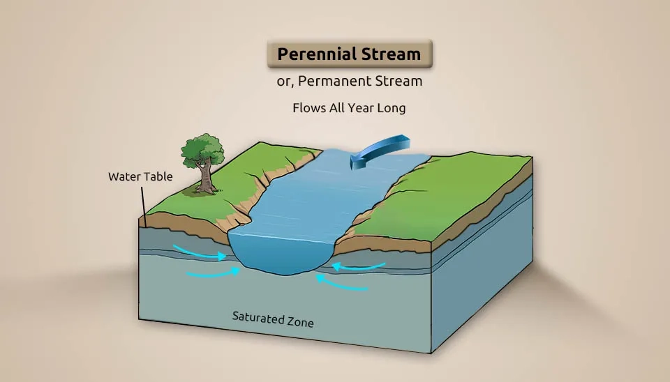
5.1. Perennial Surface Water
A perennial or permanent surface water process persists throughout the year. A perennial water body is one that is mostly dependent on rainfall or at least has seasonal exposure to another source of water (overtopping of streams and rivers, etc.). They are water bodies that do not dry up. A permanent water body is one that only shows slight seasonal variation in water level and one that retains most of its volume throughout the year. An example would be the rivers of the world, including the Ganges River (India), the Amazon River (South America), and the Nile River (Africa) (Quichimbo et al., 2020).
Fig. 11. Visualizing how a permanent stream maintains flow, linked to the water table.
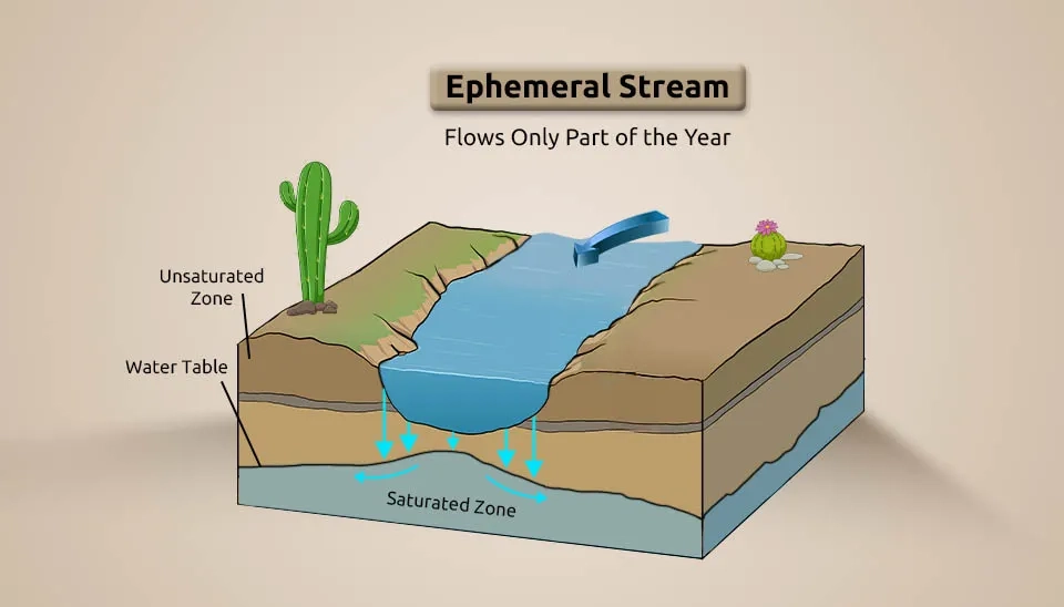
5.2. Ephemeral Surface Water
Phemeral, or semi-permanent, surface water is subject to occasional, periodic, or protracted Fluss-Cessation und/oder drying. Ephemeral surface water includes small creeks, lagoons, and water holes (Rau et al., 2017). Intermittent rivers and ephemeral streams cover a considerable area of the global river network, and their extent is increasing due to the combined effects of climate and land-use changes (Gómez-Gener et al., 2021).
Fig. 12. Ephemeral Surface Water.
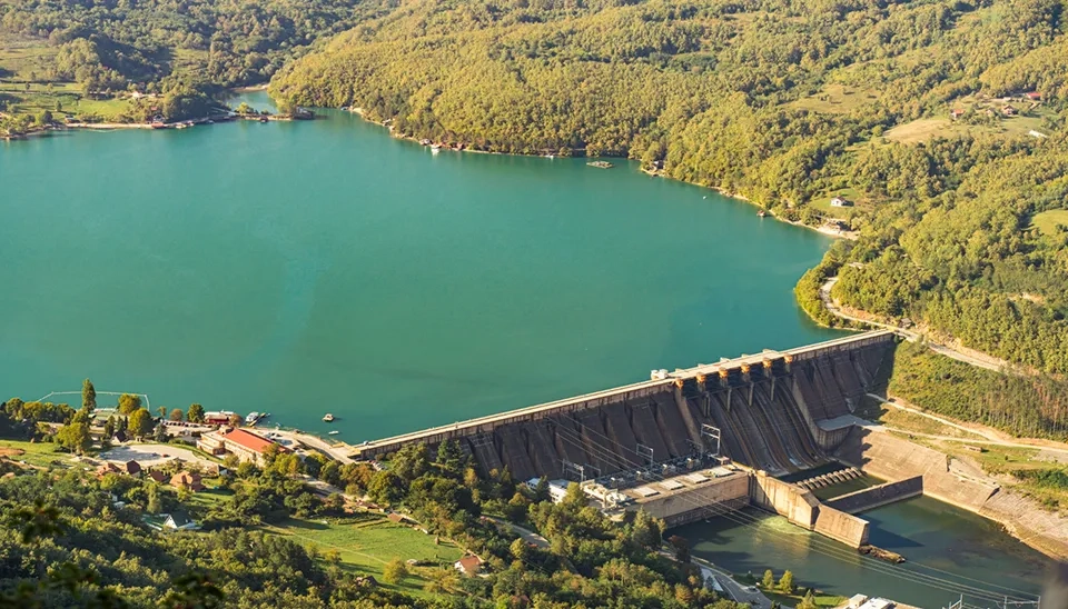
5.3. Man-made Surface Water
Man-made surface water is found in artificial structures or infrastructure designed by humans, such as dams, reservoirs, and artificial swamps. Man-made surface water can be intended for aesthetic purposes but is also an appealing energy source. The stored water can be used for irrigation, purified drinking water, or producing energy. Seasonal changes in runoff and precipitation feed the reservoir. There are vast differences in the size of man-made reservoirs, such as big artificial lakes or small pond-like water bodies (Zhou et al., 2022).
Fig. 13. A large dam holding back a turquoise-colored reservoir, surrounded by lush green forests.
6. Surface Water Flood
Floods occur when precipitation and runoff exceed the capacity of a river channel to carry the increased discharge. Nature has provided river channels or floodplains to carry runoff water from the land surface to the oceans. Flood events are one of the most damaging natural hazards that account for the majority of all economic losses from natural hazards worldwide (Bernet et al., 2019).
Fig. 14. Urban flooding event, showing a street inundated by excess surface water.
7. Conclusion
In conclusion, surface water is a vital resource that supports various human activities and ecosystems. It includes all water bodies that accumulate on the Earth's surface. Surface water is used for drinking water, irrigation, wastewater treatment, livestock, industrial uses, hydropower, and recreation. Sustainable management of surface water resources is crucial to ensure their long-term availability for various uses and to maintain healthy ecosystems. Surface water is mostly produced by precipitation and runoff from nearby areas, and its levels and presence fluctuate based on precipitation, evaporation, or water moving and transitioning into groundwater.


Comments
No comments yet
Be the first to comment
Share your thoughts and start the conversation.