The Global Precipitation Measurement (GPM) Products
A global eye on every drop: Unveiling the Earth's pulse through the precision of GPM technology.
FFarideh
· 20 min read· 10 views

A global eye on every drop: Unveiling the Earth's pulse through the precision of GPM technology.
Global Precipitation Measurement
Quick answers to common questions.
Did you ever wonder how the GPM Core Observatory is able to collect and process massive amounts of data in such a short amount of time?
The Global Precipitation Measurement (GPM) products play a significant role in our understanding and monitoring of The Earth's precipitation patterns. With the ability to precisely measure and analyze rainfall and snowfall data on a worldwide level, these products provide valuable insights into the water cycle, weather patterns, and climate change. Whether it's estimating severe weather events, managing water resources, or learning long-term climate trends, the GPM products play a key role for scientists, meteorologists, and decision-makers worldwide.
The GPM Core Observatory will send observational data to the GPM Mission Operations Centre at the NASA/Goddard Space SpaceFlight Centre (GSFC) via the NASA Tracking and Data Relay Satellite System (TDRSS). The Precipitation Processing System (PPS) at GSFC (Greenbelt, Maryland) is where NASA handles data processing, whereas the Tsukuba Space Centre (Tsukuba, Ibaraki, Japan) in the Mission Operations System (MOS) is responsible for JAXA's data processing. NASA's Precipitation Processing System (PPS) and JAXA's data distribution system will quickly process this level 0 data into higher-level products in near-real time (within 3 hours of observation), followed by more comprehensive and higher-quality research products within 48 hours (Skofronick-Jackson et al., 2017). The GES DISC arranges and stores GPM data products according to three levels: Level-1, Level-2, and Level-3, as specified by the NASA Earth Observing System Data and Information System (EOSDIS) (Liu et al., 2017). One of the main components of the GPM Mission is the Precipitation Processing System (PPS). The functions of PPS will be divided between NASA, JAXA, and European Space
Agency (ESA), with the primary node at NASA GSFC. The primary roles of the PPS include acquiring level 0 and 1 sensor data, maintaining consistent level 1 calibrated radiometer brightness temperatures (TBs) and radar reflectivities (Zs), processing level 1 data into standardised level 2 and 3 precipitation products, distributing these products via both "push" and "pull" data transfer methods, and ensuring the preservation of all acquired or produced data products by the PPS (Smith et al., 2004).
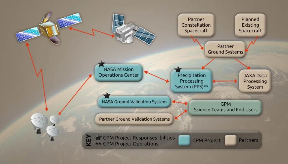
Table 1. GPM Standard Products | GPM Products
Level | Instrument | Spatial Resolution & Coverage |
2 | DPR-Ku | • 5.2km x 125m • Single orbit • 16 orbits/day (70°S-70°N) |
Download Full Table of GPM Standard Products
The PPS processes raw instrument data (level 0 data) received during routine operations in near-real time using science algorithms to generate calibrated, swath-level instrument level 1 data. JAXA’s MOC processes DPR products. JAXA computes geophysical parameters (level 2 data products), such as precipitation rate at the swath-level resolution, using supplementary algorithms. At the final stage of processing, level 3 algorithms generate gridded and accumulated geophysical parameters. In the future, level 4 data products resulting from model-assimilated precipitation forecasts and analyses are anticipated to be accessible (Skofronick-Jackson et al., 2017). Figure 1 shows the GPM data processing overview. Level-1 products in the GPM satellite are divided into three categories: Level-1A, Level-1B, and Level-1C (e.g., 1AGMI, 1BGMI, or 1CGMI). Level-1A denotes sensor data at full resolution, time-referenced, and enriched with calibration and georeferencing details. Sensor units are derived from the processing of Level 1A data, resulting in Level 1B. Level-1C has been added for inter-calibrated microwave brightness temperature products from GPM constellation satellites (Liu et al., 2017) so that multi-sensor and multi-satellite precipitation retrieval algorithms like GPM IMERG stay consistent. An A in level 2 products means that the product contains data from one instrument (2AKu and 2ADPR products), while for level 2-B, the involvement of multiple instruments is indicated in the product's creation (2BCMB that includes both DPR and GMI instruments).
The GPM Core Observatory and constellation satellites deliver precipitation data that is vital, ranging from micro to local to global scales, utilizing retrieved precipitation particle size distributions, regional precipitation estimates with 5–15 km resolution, and merged global precipitation (Skofronick-Jackson et al., 2017), and provide precipitation retrievals using different algorithms, including DPR-only, DPR+GMI, and radar-enhanced radiometer algorithms with a hydrometeor database based on Core sensor measurements (Hou et al., 2014).
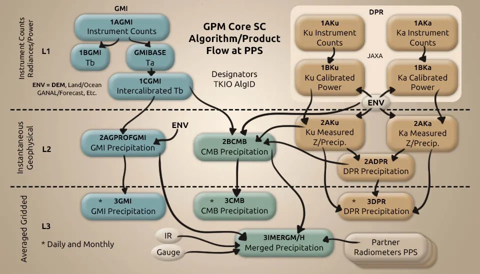
Table 2. The definition of the GPM products level (GPM Data Handbook, 2023; NASA and GSFC, 2017; Liu et al., 2017)
Level | Definition |
1 | In the original observation geometry of the instrument, Level 1 products may contain instrument-independent physical variables such as radar reflectivity or microwave brightness temperature. Engineering variables found in other Level 1 products, like radar returned power, rely on specific instruments. |
2 | Geophysical variables like precipitation rate are included in Level 2 products through additional processing. The observation geometry of Level 2 products is usually the same as that of the corresponding Level 1 product. |
3 | Time-averaged and space-averaged data, like monthly average precipitation rates, are found in Level 3 products. |
All GPM data is saved in the HDF5 format (Stocker et al. 2018). The general format for naming files in GPM is as follows (NASA and GSFC, 2017):
dataType.satellite.instrument.algorithm Name.start Date-StartTime-EndTime.
sequenceIndicator.VdataVersion.extension
The data type comprises a data level indicator and a sublevel indicator, both of which are alphanumeric values.The data type uses a number to represent the processing level and a letter to represent a specific sublevel.. Table 1 presents the data level values for GPM at launch. The data type of the GPM file name is described in Table 3 (NASA and GSFC, 2017).
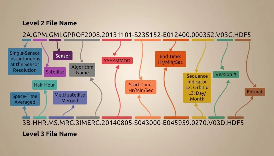
Table 3. Detailed Classification of GPM Data Levels and Sublevels
Level | sublevel | Definition |
1 | A | Instrument count, geolocated. |
B | Geolocated, calibrated Tb, or radar power. | |
C | Inter Calibrated brightness temperatures (Tc). |
Download Full Table of Classification of GPM
GPM core satellite data is divided into two categories: Standard products and near-real-time products. You can trust the accuracy of the standard products from NASA and JAXA. The target audience for near-real-time products includes meteorological organisations, among others. There are some differences between these products, including the file coverage or input auxiliary data to shorten latency for near-real-time products (GPM Data Handbook, 2023). We divide the types of GPM products from a single instrument or multiple instruments into three categories and describe them as follows:
Level 1-3 Dual-Frequency Precipitation Radar (DPR) Products.
Level 1-3 Global Microwave Infrared (GMI) Products.
DPR/GMI combined product
The GPM Data Handbook, 2023, provides the following description of Dual-Frequency Precipitation Radar (DPR) standard product processing:
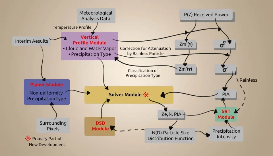
The Level 1A product serves as input data for level 1B in DPR processing, which outputs a product containing a received power profile and geometric information. Radiometric correction is performed during processing, while missing data is processed using missing data information. Additionally, scan time is corrected, and geometric calculations are done for time, latitude, longitude, and height of each scan.
In addition to the observed power value profiles from KuPR and KaPR, the level 2 processing algorithm of the dual-frequency precipitation radar estimates a profile of precipitation intensity. Additionally, it provides estimates for top height, bright band height, and precipitation type.
In Ku/Ka/DPR L2 products, we use the following scan names: 1) NS = normal scan (49-angle bin-blue); 2) MS = matched beam scan (25-angle bin-yellow); 3) HS = high-sensitivity beam scan (24-angle bin-red) (Overview of GPM Products, 2017).
Fig. 5. This figure illustrates the scan pattern of the Dual-frequency Precipitation Radar (DPR) onboard the GPM Core Observatory. It shows the arrangement of beams for Ku-band (blue), Ka-band matched beam (yellow), and Ka-band high-sensitivity beam (pink) across the swath. The scan proceeds from left to right in the flight direction, covering 49 KuPR beams and 25 KaPR beams.
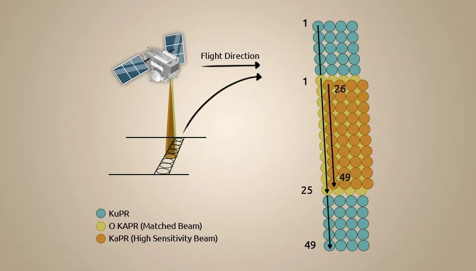
Figure 6. This figure shows the swath configuration of the KuPR and KaPR radars onboard GPM under standard observation mode. The KuPR covers a wider swath (245 km, 49 beams), while KaPR operates within a narrower central portion (125 km, 25 beams) using both matched and interlaced scan modes. The interlaced Ka-band (high sensitivity) beams offer enhanced vertical resolution with reduced horizontal coverage.
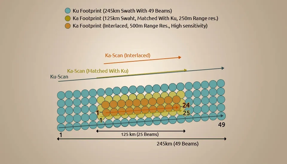
Fig. 7 displays the updated scan pattern of KuPR and KaPR radars after the KaPR scan mode change. The KuPR still spans 245 km (49 beams), while KaPR is now divided into two parts: the inner swath (yellow) matches with Ku, and the outer swath (pink) operating in high-sensitivity mode. This adjustment allows for extended coverage and enhanced vertical resolution using the Ka-band high-sensitivity beams.
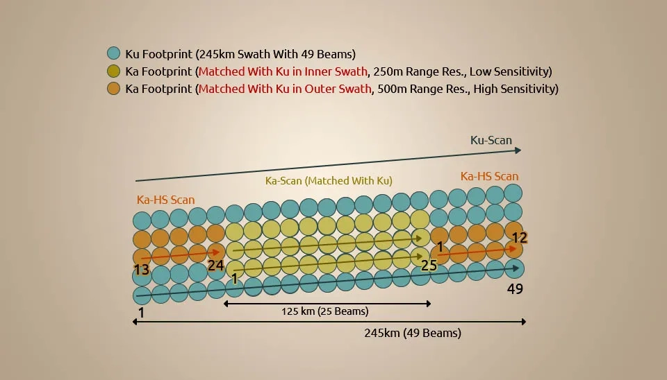
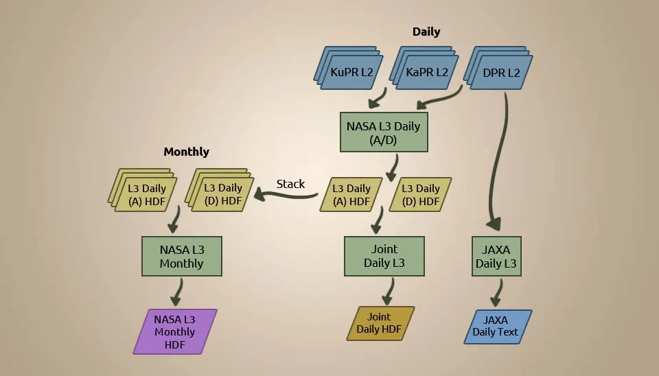
Fig. 4 illustrates the flow of the Level 3 standard processing algorithm, where A/D denotes ascending/descending. Each month, 28–30 daily products contribute to the creation of monthly products on the data stack. The algorithm employed by NASA is utilized for processing HDF products daily and monthly. JAXA processes text products.
Within just one hour of data collection, GMI products are accessible. GMI products include: 1AGMI holds unprocessed packet information from GMI science data on the GPM satellite. GMI L1B Brightness Temperature, By utilizing the Level 1B algorithm and software, Level 0 counts are transformed into geolocated and calibrated antenna (Ta) and brightness temperatures (Tb). The radiometric calibration of the sensor tells us what Ta is, and Tb is found by taking Ta and adjusting for antenna pattern and vicarious calibrations. GMI L1C Inter-Calibrated
Brightness Temperature; GMI L2 Precipitation, including main parameters (cloud mask classification, precipitation rate, total water vapour column, total cloud liquid/ice water, sea surface temperature); GMI L3 Precipitation with 0.1-degree resolution (Overview of GPM Product, 2017) .
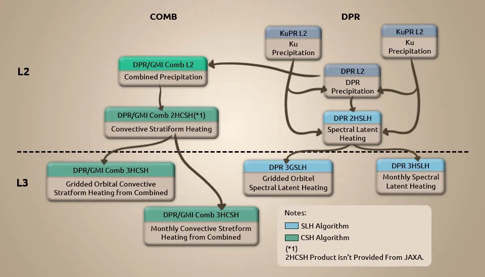
DPR/GMI combined products consist of the standard product (STD) and the near-real-time product (NRT). DPR/GMI combined products include: 1) COMB L2 Precipitation Rate (STD; resolution: 5 km (horizontal), 250 m (vertical), NRT; resolution: 5 km (horizontal), 125/250 m (vertical); 2) COMB L3 Precipitation (resolution: 0.25, 0.5 degrees); 3) COMB L3 Gridded Orbital Spectral Latent Heating; and 4) COMB L3 Monthly Spectral Latent Heating.
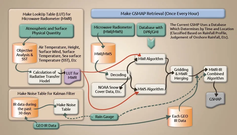
It is possible to get high-resolution global estimates of precipitation over short periods of time (one hour) and large areas (0.1 degree) by combining data from passive microwave radiometers and infrared (IR) radiometers (Ushio et al., 2009). DPR data and information have improved the accuracy of the global satellite mapping of precipitation algorithms. This approach generates a global satellite precipitation map by averaging spatio-temporal data from multiple microwave radiometers, such as the GPM Microwave Imager (GMI), and incorporating cloud travel information from geostationary IR data. The processing of global satellite precipitation mapping can be done through standard methods or near-real-time methods. Standard processing involves averaging hourly observation data on a monthly basis, whereas near-real-time processing provides more frequent data updates (every hour) (Overview of GPM Product, 2017).
NASA's team has developed the Integrated Multi-satellitE Retrievals for GPM (IMERG), an essential NRT national and gridded product, as a global successor to TMPA that fills gaps in precipitation data using GPM and partner satellite precipitation estimates. The (IMERG) algorithm was adopted by Lagrangian time interpolation, or “morphing”, and monthly gauge information (Huffman et al., 2017). The latest version, 06B IMERG, provides global coverage with fine spatial (0.1°× 0.1°) and temporal (half-hourly) resolution as a multi-satellite precipitation product. IMERG is generated through the combination of satellite observations and gauge analysis by NASA's precipitation processing system (PPS) using passive microwave (PMW) and infrared (IR) observations (Wang et al., 2021). The IMERG product line consists of three variations: IMERG Early Run, Late Run, and Final Run, each with different latency and product requirements. The data from both the early and late runs are considered near real-time products, with a latency of 4 h and 12 h, respectively. The purpose of near-real-time products is to aid scientists in forecasting the effects of significant storms, while the Final Run product, available after a 2.5-month delay, is designed for research purposes. By utilizing the GPM IMERG near-real-time precipitation products, scientifically based applications such as flood forecasting and hydrometeorological modeling can function as an early warning system, safeguarding lives and property from impending disasters (Tang et al., 2016).
The Global Precipitation Measurement Mission (GPM) offers unparalleled global precipitation datasets, utilizing advanced technologies such as DPR's dual-frequency channels and GMI's high-frequency channels in retrieval algorithms. Merging GPM multi-satellite estimates with IR satellite data enables temporal resolutions as low as 30 minutes and spatial resolutions of 0.1° × 0.1°. This process results in more extensive coverage, higher spatial and temporal resolution, and enhanced accuracy in rainfall and snowfall estimates, particularly in high latitude and elevation regions. The NRT data, including the crucial IMERG gridded product, is complemented with model and ancillary data, undergoing meticulous processing for accuracy and stability. Delays in NRT products ensure precision, incorporating high-quality ancillary and geolocation data. Calibration through CORRA and inter-calibration techniques enhances the reliability of partner satellite estimates. The IMERG product, with a spatial resolution of 0.1° × 0.1°, is available every 30 minutes, contributing significantly to real-time applications. Additionally, JAXA utilizes inter-calibrated brightness temperature products from the GPM constellation to produce the Global Satellite Mapping of Precipitation (GSMaP) national product. Together, these advancements propel GPM into a crucial role for long-term, accurate precipitation investigations on a global scale.
Keep reading


Comments
No comments yet
Be the first to comment
Share your thoughts and start the conversation.