The world is free of fresh water! or a world with an unfair distribution of fresh water! These topics will be the headlines of newspapers and news in the future. According to the United Nations report, it is predicted that the world population will increase to 9.7 billion and 11 billion people by 2050 and 2100, respectively (United Nations, 2019). The increase in population followed by the growth of the economy, agriculture and industry will lead to a rise in water demand and water shortage. Examining the trend of water consumption and the continuous reduction of available fresh water resources in the past is proof of this. So during the last 100 years, per capita water consumption has increased from 500 square kilometers per year to 3800 cubic kilometers per year (7.6 times in a century). Therefore, the water crisis will be severe in the future and will threaten all aspects of human life (IPCC, 2019; Chawla et al., 2020).
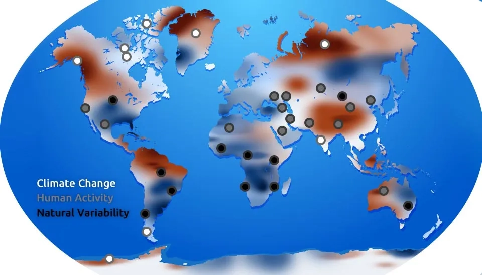
Fig. 1. Uneven global freshwater distribution due to climate change, human activities, and natural variability.
Water is constantly circulating in the hydrological cycle, and the assessment and management of water resources require following the flow of water. Water reservoirs consisting of natural reservoirs such as lakes and wetlands and artificial reservoirs such as dams help to meet human needs and the availability of necessary water for human society, however, the climate system and human withdrawals cause the uneven and unfair distribution of renewable fresh water in the world (from a temporal and spatial point of view) so that more than two billion people around the world are facing severe water challenges. In the meantime, climate change should not be neglected, because climate change on the one hand accelerates the water cycle and increases renewable fresh water, and on the other hand, by changing seasonal patterns and intensifying the magnitude and frequency of extreme events, it makes water stress more prominent. Reducing vulnerability and maintaining water security is an important step in maintaining the health of humans and other organisms and the ecosystem and biodiversity in general (
), which requires continuous water quantity assessment.
1. Water Quantity Assessment and Monitoring
Lack of water has brought many challenges to economic, social, and livelihood development, and therefore, since the late 1980s, researchers have paid special attention to water scarcity. During the last decades, indicators have been presented to identify the quantity of water and to detect water shortage. In addition, models are presented that are able to quantify water availability and use. However, challenges remain in the field of green water, environmental flow, and quantitative dimensions of water, which require the efforts of hydrologists, economists, social scientists, and environmental scientists to develop integrated approaches to understanding water quantity (Liu et al., 2017).
The development of multi-source earth observation techniques has created a new approach to water monitoring. In the past decades, these techniques have covered a wide range of water resources, from natural glaciers to rivers. In addition, the importance of long-term global scale, sustainable, and accurate monitoring of water requires cloud computing, big data, and efficient tools such as remote sensing (Huang et al., 2023). In the following, we discuss the applications of remote sensing techniques for water quantity assessment in each of the water resources.
2. Applications of Remote Sensing Techniques for Water Quantity Assessment
Remote sensing is a tool to obtain data related to phenomena, areas, and objects without direct physical contact and through sensors, lasers, and cameras located in airplanes, satellites, and shuttles. Remote sensing sensors, which are active or passive depending on their type, are able to detect and analyze the energy reflected from the earth (Di and Yu, 2023).
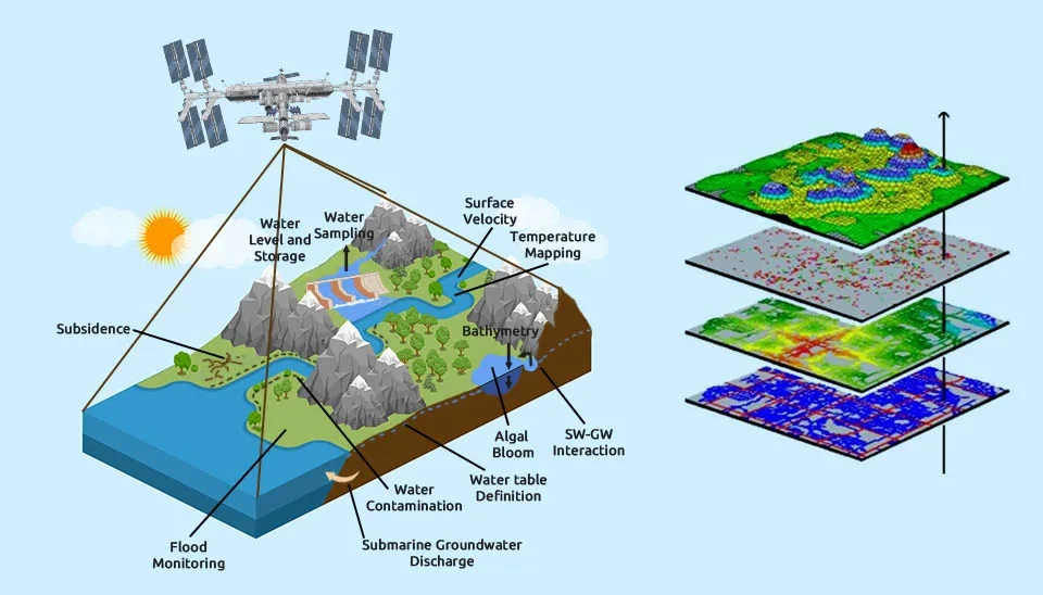
Fig. 2. Remote sensing applications in water quantity assessment, including water level, storage, surface velocity, groundwater interaction, and flood monitoring.
One of the applications of remote sensing that has attracted the attention of researchers in recent years is the evaluation of water quantity and quality. Remote sensing covers a wide range of surface and underground waters, which can be mentioned in coastal, ocean, natural resource management, and hazard assessment applications. Coastline change monitoring, groundwater level, water storage, ocean circulation monitoring, current tracking, and flood and storm assessment are some of the applications of remote sensing that are related to water quantity. Applications of remote sensing in water quantity monitoring help to a better and more accurate understanding of water resources to help protect natural resources by obtaining management strategies and preventing foreseeable risks (Rana and Neeru, 2017).
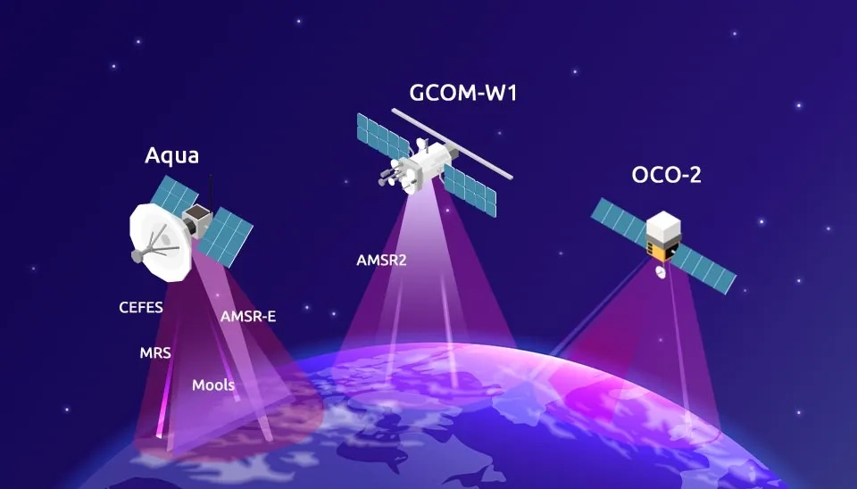
Fig. 3. Examples of satellites like Aqua, GCOM-W1, and OCO-2 employed in remote sensing for global water quantity assessment.
2.1. Groundwater Applications
Groundwaters are natural resources of fresh water that have suffered from groundwater depletion due to increased demand and excessive consumption. Despite the great importance of groundwater in the livelihood of humans and other ecosystems, the presence of groundwater under the earth’s surface has made the quantitative assessment of groundwater challenging. However, remote sensing is considered a powerful tool in groundwater quantity monitoring. Remote sensing is able to evaluate groundwater both directly and indirectly (through monitoring proxies such as soil moisture and evapotranspiration) at local, regional, and global scales. The results of remote sensing are combined with in-situ observational data such as hydraulic heads of wells and numerical models to increase the accuracy of quantitative groundwater assessment. The following methods are common techniques based on remote sensing in groundwater quantitative assessment (Adams, 2022):
Groundwater quantity monitoring through identification of mass changes with gravitational measurements
Evaluation of ground surface height changes using Interferometric Synthetic Aperture Radar (InSAR)
Light Detection and Ranging (LiDAR)
Airborne Electromagnetic Systems (AEMs)
Satellite altimetry
In addition, remote sensing provides spatial and temporal distribution of data related to input parameters for groundwater models and helps to extract and identify hydrogeologic data, subsurface flow, and recharge distribution to make more accurate groundwater quantity monitoring (Brunner et al., 2007; Jha et al., 2007).
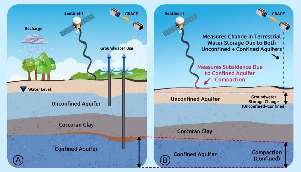
Fig. 4. Remote sensing of groundwater quantity using Sentinel-1 and GRACE satellites, illustrating measurements of recharge, subsidence, and storage changes.
2.2. Streamflow Applications
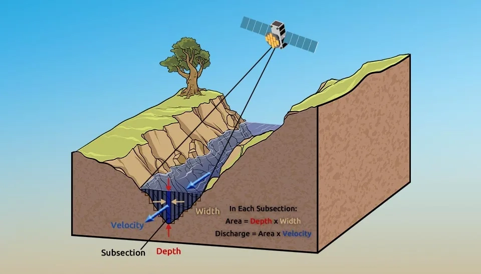
Streamflow is one of the important processes of the hydrologic cycle, which is quantified by the river discharge. River discharge is the amount of water that flows through the river section per unit of time and is expressed in cubic meters per second. The importance of river flow is in calculating water balance and evaluating water resources and flood risk management. However, the in-situ measurement of river discharge using stream gauges and stage-discharge relationship faces limitations. Expenditure, lack of sufficient spatial distribution, and difficulty of installing stream gauges in remote and inaccessible areas are some of these limitations. The solution to overcome the limitations of in situ measurement is remote sensing. Remote sensing is capable of estimating water discharge and storage worldwide to improve understanding of the global streamflow network. Although remote sensing cannot directly measure the river discharge, satellite sensors are able to measure the hydraulic variables involved in the river discharge (including river width, water level height, slope, and flow velocity) to determine the river discharge using hydraulic discharge relationships (Fig. 4). Researchers have widely used radar altimeters in water quantity to estimate water level changes and river discharge (Alsdorf and Lettenmaier, 2003; Kim et al., 2019).
Fig. 5. Indirect estimation of streamflow using remote sensing. Satellite sensors measure hydraulic variables (width, depth, velocity) to calculate river discharge.
2.3. Terrestrial Water Storage Applications
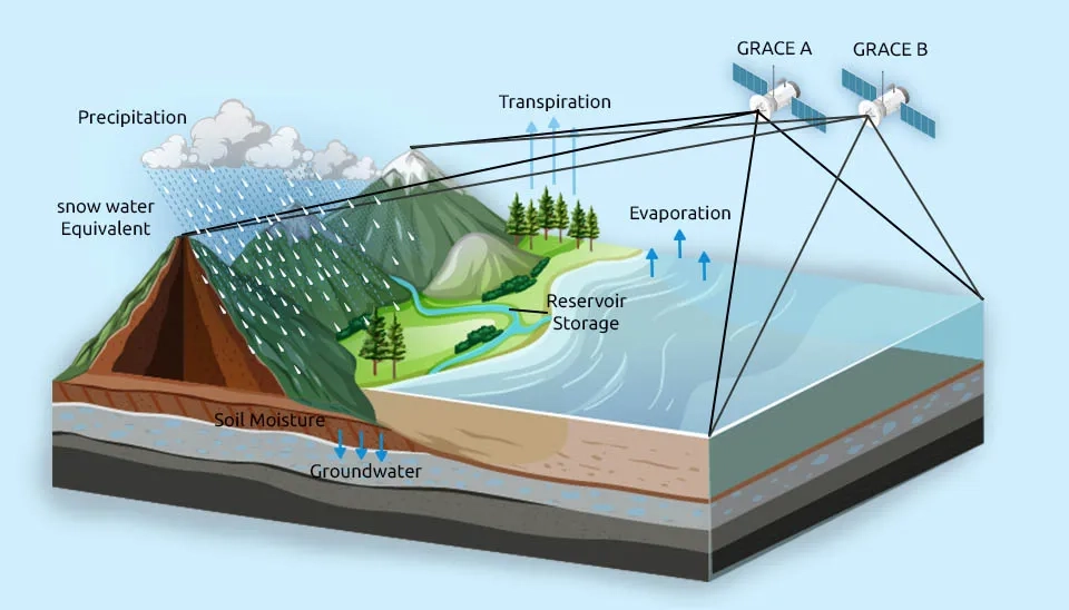
Terrestrial Water Storage is the sum of water above the ground and below the ground, which is very important in the hydrological cycle. Although it is difficult to measure terrestrial water storage, the Gravity Recovery and Climate Experiment (GRACE), launched in 2002, was able to estimate the temporal variations of the earth's gravity at a spatial resolution of 400 to 40,000 km and 30-day time intervals to assess terrestrial water storage. The results obtained from GRACE are useful in estimating surface water storage, terrestrial freshwater discharge, and soil moisture and generally in understanding hydrologic fluxes. After the end of the GRACE mission in 2017, GRACE-FO (GRACE-Follow), which was equipped with a laser interferometry system and was launched in 2018, has higher accuracy and has revealed new horizons of the components of the hydrological cycle (Tapley et al., 2004; Zaitchik et al., 2008; Frappart and Ramillien, 2018; Xiong et al., 2021).
Fig. 6. GRACE satellite mission for terrestrial water storage assessment, showing components of the hydrological cycle measured.
2.4. Reservoir Applications
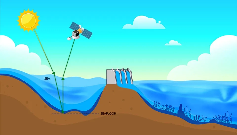
Water resources management requires monitoring the quantity and quality of reservoirs because reservoirs adjust and control seasonal and annual fluctuations in streamflow and play a positive and significant role in supplying water to an area during periods of drought. On the other hand, reservoirs have contributed to the continuation and protection of human life by producing hydroelectricity, continuous water supply, and flood control. However, estimating the water volume of reservoirs is difficult due to lack of access and its data is mainly limited to developed countries, which leads to disruption in modeling the impact of reservoirs on the hydrological cycle of the world.. Remote sensing is able to measure the water level and bathymetry of reservoirs and remotely monitor the quantity of reservoirs. The development of multiple radar altimeters in water quantity assessment and remote sensing tools such as MODIS, GLAS, Topex/Poseidon, ERS, Envisat, Jason, and GFO have helped to analyze time series and better understand large reservoirs and river basin modeling (Gao et al., 2011).
Fig. 7. Water level estimation in reservoirs using radar altimetry. The satellite sensor measures the distance to the water surface to determine water height.
2.5. Coastal, Lake, Sea, and Ocean Applications
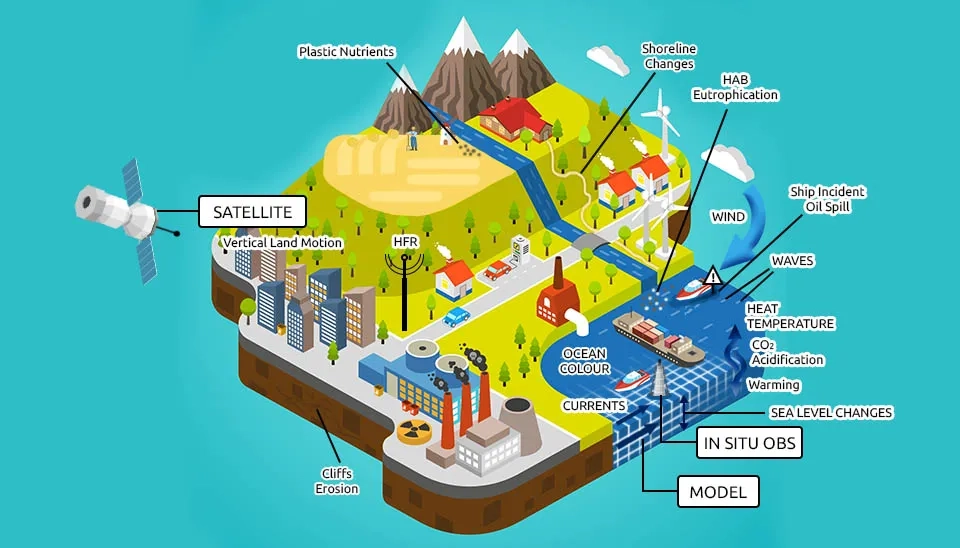
In addition to the importance of qualitative monitoring of coastal ecosystems and their nearby water sources, it is necessary to evaluate and monitor coastal areas, seas, lakes, and oceans from a quantitative perspective, which facilitates their monitoring using remote sensing methods. For example, altimetry datasets provide information about the water level of the world's great lakes and rivers in the last three decades. Radar imagers, scatterometers, and altimeters have many applications in ocean waves, ocean winds, sea surface height, and coastal currents. In addition, airborne light detecting and ranging systems are able to extract bathymetry even in turbid water resources, which is needed in water volume assessment. Quantitative data obtained from remote sensing are used by researchers for predicting ungauged basins, assessing the effect of climate change on water resources, monitoring the availability of water resources, and hydrological modeling. However, achieving a high temporal, spatial, and spectral resolution requires the use of both satellite and aircraft and their calibration and validation with in-situ field observations to achieve a more accurate understanding of the complex quantity of coastal areas, seas, lakes, and oceans (Klemas, 2011).
Fig. 8. Integrated water resource monitoring in coastal and ocean environments, combining remote sensing, in-situ observations, and models.
3. Conclusion
The growth of technology and the development of methods based on remote sensing have made them superior to conventional in-site methods. Unlike in-situ and field methods, remote sensing-based methods are low-cost and efficient and cover a wide spatial and temporal scale. Therefore, in recent decades, its applications have been welcomed by researchers, which can be mentioned in the applications of remote sensing in water quantity monitoring. In this article, the applications of remote sensing techniques for water quantity assessment in all types of water bodies consisting of subsurface resources (groundwater) and surface resources (reservoir, coastal, lake, sea, and ocean) were reviewed. Estimation of metocean variables, estimation of hydraulic variables, assessment of water volume, and bathymetry mapping are applications of remote sensing in water quantity. Most of these applications are available through altimeters, which shows the ability of radar altimeters in water quantity monitoring. However, remote sensing data is expected to be calibrated, verified, and integrated with in-situ observational data and hydrological models in order to estimate a more accurate prediction of the quantitative status of water and the hydrological cycle. Achieving this goal leads to the development of sustainable strategies and dealing with hazard risks.


Comments
No comments yet
Be the first to comment
Share your thoughts and start the conversation.