How can you measure the status of irrigation, crop growth, and pests in a multi-hectare farm? Now imagine the same situation on a global scale. The production of 9.5 billion tons of agricultural products in one year (FAO, 2021) requires continuous agriculture monitoring. The most efficient, safest, and most cost-effective method is remote sensing! How? We will discuss it in detail in this article.
The continuous growth of the population has increased the demand for food since food production must increase by 50% compared to 2013 to meet the needs of about 9.1 billion people in 2050(FAO, 2017). Agricultural management and its sustainable development will be the key answer to human needs in the future. This goal will not be realized except by collecting reliable and timely information about the type and performance of the crop, preparing agricultural maps, monitoring agricultural activities, preparing crop statistics, and studying the impact of environmental factors on them. Therefore, crop mapping, crop performance prediction, and precision agriculture are essential in ensuring food security, supply chain management in agribusiness, and adapting crop management practices (Joshi et al., 2023). The growth of agriculture and precision agriculture requires remote sensing technology to make the best management choices by providing new solutions to improve and facilitate agricultural practices (Pande and Moharir, 2023).
Table 1. Main applications of remote sensing in agriculture
5 main Applications of Remote Sensing in Agriculture
Sub-applications
Tools and Methods
Remote Sensing in Irrigation
- Monitoring of water demand
- Improving water consumption
- Irrigation scheduling
- Assessing water resources
- EvapoTranspiration (ET) estimation
- Infrared thermography
- Crop index
Remote Sensing in Pests and Diseases Detection
- Diagnosis of diseases and pests
- Monitoring of diseases and pests
- Weed detection and control
- Biotic stress detection
- Crop health monitoring
- Visible and near-infrared spectral sensors (VIS-NIR)
- Fluorescence and thermal sensors
- Synthetic Aperture Radar (SAR)
- Light detection and ranging (Lidar)
- Statistical and regression analysis
- Machine learning and deep learning
Remote Sensing in Precision Agriculture
- Timing and schedule
- Management
- Control
- Prediction
- Precise farming
- Regression and experimental models
- Machine learning
- Plant indices
Remote Sensing in Crop Growth Assessment
- Crop yield
- Crop growth
- Canopy and biomass volume
- Crop phenology
- aPAR and fPAR
- Regression-based methods
- Physics-based methods
Remote Sensing Data in Crop Models
- Crop models
- Soil moisture and characteristics
- Crop growth status
- Abiotic stresses data
- Extreme events
- Weather and meteorological data
- Remote sensing data
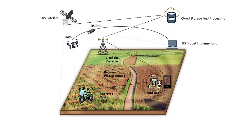
Components of remote Sensing for Sustainable Agriculture
1. The Importance of Remote Sensing for Sustainable Agriculture
Agriculture is one of the vital sectors for the survival of humans and animals. The development and improvement of agriculture will bring many economic and social consequences, including economic growth and poverty alleviation. With the advent of technology and advances in pesticides, fertilizers, and irrigation, modern farming practices have significantly improved crop yields compared to traditional farming practices (Hazell and Wood, 2007). Meanwhile, remote sensing provides an efficient tool for monitoring agriculture at large spatial scales.
Remote sensing can provide more low-cost, automated, and continuous measurements than in-situ measurements through data transmission systems and allow the user (here the farmer and related persons) to access the collected data remotely, via smartphone or similar devices. Most of these methods and related systems are very sensitive and can be effective in field conditions for a long time (Fernández, 2014). Therefore, remote sensing technology has been favored by farmers and researchers in recent years, and in the following, we will discuss applications of remote sensing for sustainable agriculture.
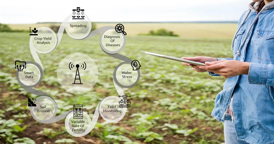
2. Applications of Remote Sensing in Agriculture
Multispectral information, local and global coverage, and increasing the spatial, spectral, and temporal resolution of remote sensing data make them a tool for monitoring crops at local, regional, and global scales. Therefore, researchers have used remote sensing in agricultural monitoring, to categorize and predict agricultural products. Among the applications of remote sensing for sustainable agriculture, the following can be mentioned (Moran et al., 1997; Alvino and Marino, 2017):
Precise farming
Surveillance and monitoring of farms
Crop yield assessment
Sampling procedure from soil and crop
Improving water consumption (irrigation) according to the plant
Canopy volume and biomass detection, crop cover fraction
Light penetration of the canopy
Application in canopy measurements
Soil nutrients analysis
Mapping soil characteristics and types
Wind, water erosion, flooding, and extreme events
Monitoring vegetation types
Assessing water resources
In the following, we have classified the above applications into 5 categories and will discuss in detail the 5 important applications of remote sensing for sustainable agriculture (Karthikeyan et al., 2020).
Various applications of remote sensing for sustainable agriculture
2.1. Remote Sensing in Irrigation
One of the important applications of remote sensing in agricultural monitoring is the accurate identification of irrigated areas through monitoring the phenological characteristics of the product and multi-temporal image. The amount of water required by the plant is considered a vital biophysical feature, which is essential for irrigation management and optimal use of water resources. The amount of water required by the plant is determined by the water content in the soil or the salt content of the soil in saline soils (salinity is the limiting factor for water absorption). On the other hand, plant diseases can also affect crop water demand by decreasing water absorption, which should also be considered for irrigation monitoring (Peña-Arancibia et al., 2016). The amount of water required by the product can also be measured at the canopy and leaf levels, by monitoring the water potential of the leaf or stem, or leaf water. However, the interaction of plant factors (root signaling, aerodynamic characteristics of vegetation, genetic control of crop performance) and environmental factors (solar radiation, wind speed, and direction, air humidity, and air temperature) makes it a challenge to determine the water needed for irrigation. Past studies show that there are several methods for estimating available water consumption with remote sensing-based techniques. This technique can be divided into three categories: 1) methods related to evapotranspiration (ET) estimation; 2) infrared thermography; and 3) crop characteristics (Alvino and Marino, 2017; Casa et al., 2009).
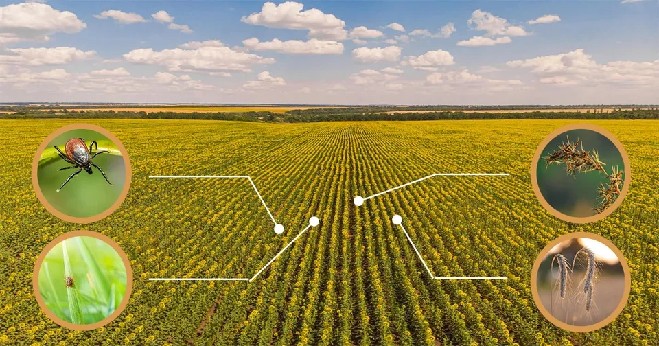
2.2. Remote Sensing in Pests and Diseases Detection
Plant diseases and pests threaten agriculture significantly around the world. The implementation of non-contact, efficient, and cost-effective methods for the diagnosis and monitoring of plant diseases and pests on a diverse spatial scale can greatly facilitate the protection of plants. Therefore, several methods of remote sensing in agricultural monitoring have been introduced to identify and monitor plant diseases and pests in different ways, including sensing technologies, feature extraction, and monitoring algorithms. Remote sensing systems are divided into four categories based on their characteristics in diagnosing and monitoring plant diseases and pests, which are: 1)Visible and near-infrared spectral sensors (VIS-NIR), 2)fluorescence and thermal sensors, 3)Synthetic Aperture Radar (SAR), and 4)Light detection and ranging (Lidar) systems. Meanwhile, statistical discriminant analysis, regression-based models, and machine learning and deep learning algorithms can help improve the performance of remote sensing methods. Algorithms and methods based on remote sensing enable farmers to distinguish diseases and pests and retrieve the infection severity (Zhang et al., 2019).
Applications of remote sensing in agricultural monitoring for pests and disease detection
2.3. Remote Sensing in Precision Agriculture
The development of technology and the introduction of tools such as the Internet of Things, spatial technologies, and artificial intelligence have caused the agricultural production sector to jump. The purpose of precision agriculture is to optimize agricultural inputs by increasing production and reducing losses, which requires the use of a set of technologies, including remote sensing. The accessibility and high resolution of time, space, and spectrum have caused the use of remote sensing to increase dramatically in various aspects of precision agriculture in the last decade. Therefore, advanced techniques (regression, experimental, and machine learning) and plant indices have been developed to improve the performance of remote sensing in the management, control, prediction, and timing of agriculture in the form of precision agriculture. However, the accuracy and efficiency of the methods based on remote sensing in precision agriculture depend on the resolution of images, weather and climate conditions, the type of land and product, and analysis techniques to provide accurate and applicable systems for commercial and non-commercial use (Sishodia et al., 2020).
Remote sensing in agricultural monitoring Separation of agricultural land into finer details in precision agriculture
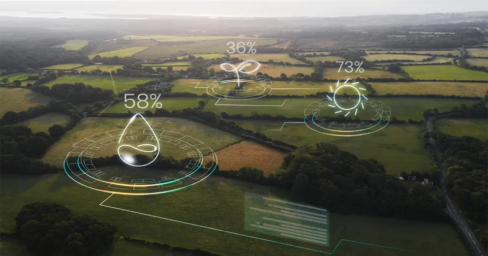
2.4. Remote Sensing in Crop Growth Assessment
Optimum crop yield depends on the sufficient supply of plant materials and their protection against pests and diseases, which requires continuous monitoring of crop growth. One of the indirect parameters for monitoring crop growth is absorbed Photosynthetically Active Radiation (aPAR) and fraction of absorbed Photosynthetically Active Radiation (fPAR). aPAR depends on incoming solar radiation and photosynthetically active radiation interception capability, and fPAR is normalized aPAR with incident solar radiation. aPAR and fPAR show how much of the incoming radiation is absorbed by the plant during photosynthesis (Gross Primary Productivity or GPP) and what rate of absorbed energy is stored as plant biomass (Net Primary Productivity or NPP) (Rembold et al., 2013; Fischer, 2015). The methods of estimating these indicators using remote sensing can be generally divided into two categories: 1) regression-based methods, and 2) physics-based methods. The methods based on remote sensing regression depend on the spectral characteristics of the product, which itself depends on the growth stage of the product, the type of product, and its health. Regression-based methods are location-dependent and cannot be spatially generalized. Therefore, it is used on a local scale. Simulation of plant growth performance on a large and global scale requires the integration of physics-based methods (Dorigo et al., 2007).
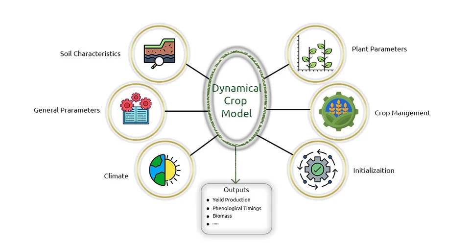
2.5. Remote Sensing Data in Crop Models
Crop models are developed by researchers to evaluate the relationship between crop growth and growth environment, which are used to ensure optimal crop performance. Crop models can identify temporal and spatial changes in the plant, however, many factors cause their errors. Among these factors, we can mention the model error in simulating and identifying plant diseases and insect pests, meteorological events such as hail, strong winds, high temperatures, etc. Another factor of error in the performance of crop models is the error caused by spatial data, including crop parameter data, soil parameter data, weather data, and data related to methods (such as soil moisture calculation method). The spatial variability of crop and soil parameters has caused the use of low-accuracy environmental data to reduce the accuracy of crop model prediction. Different methods and algorithms are presented to reduce the errors of crop models. One of the methods is to use remote sensing data to provide spatial and temporal information on soil characteristics, crop growth status, and weather data. Therefore, remote sensing data is used to improve the accuracy of forecasting and simulation of crop models. However, remote sensing data, which are mainly obtained using different optical sensors, may contain some errors in a region. However, the use of remote sensing data in crop models is expected to become more popular in the future (Jin et al., 2018).
Various components of crop models and remote sensing data as an auxiliary tool
3. Conclusion
In recent decades, the growth of the earth's population has caused the food needs of humans to increase. Limited land and water resources have made the importance of optimal agriculture more apparent than ever. In the meantime, the development of technology and the introduction of remote sensing methods have affected all aspects of human life, including agriculture and food supply. Remote sensing has been able to provide a sustainable and efficient approach to agriculture through irrigation monitoring, crop growth assessment, precision agriculture, and pest and disease detection. Therefore, it is expected that farmers will turn to remote sensing for sustainable agriculture in the future. It is worth mentioning that in this article only the applications of remote sensing in the field of agriculture were discussed, but it is necessary to use crop models, data assimilation, machine learning, deep learning, and physical and statistical models in addition to remote sensing to reach more reliable agriculture.


Comments
No comments yet
Be the first to comment
Share your thoughts and start the conversation.