
The GPM Core Observatory satellite launched in February 2014 to measure falling snow and precipitation using both Dual-Frequency Precipitation Radar (DPR) and GPM Microwave Imager (GMI) sensors.
Global challenges were the focus of the Earth Observation Summit in Washington in July 2003, which saw the participation of over 30 nations. The EOS prompted the formation of an ad hoc Group on Earth Observations (GEO), which was tasked with creating a 10-year implementation plan for a coordinated and comprehensive Earth observation system. Along with US interagency and international partners, the National Aeronautics and Space Administration (NASA) plays a significant role in GEO activities. The GPM Mission's international component makes it a possible prototype for the GEO effort. Valuable knowledge and published findings from the Tropical Rainfall Measurement Mission (TRMM), produced by U.S. and European Union research teams and dedicated scientists, have contributed to the design and development of the GPM Mission (Smith et al., 2004). The GPM Core Observatory satellite launched in February 2014 to measure falling snow and precipitation using both Dual-Frequency Precipitation Radar (DPR) and GPM Microwave Imager (GMI) sensors. In addition to a Ku-band (13.6 GHz) radar similar to the TRMM radar, the GPM observatory also includes a Ka-band radar (35.5 GHz). The Dual-Frequency Precipitation Radar (DPR) is the name given to them when considered together. The GPM Core Observatory's radiometer component is the GPM Microwave Imager, a 13-channel passive microwave radiometer with frequencies from 10 to 183 GHz (Hou et al., 2014).
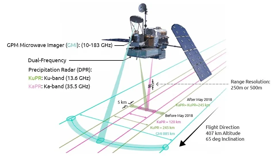
Table 1. Instruments onboard the GPM | GPM Instruments | Global Precipitation Measurement Instruments | Global Precipitation Measurement Sensors | GPM Device
Instrument Name | DPR | ||
GMI
KuPR | KaPR |
Band frequencies | 13.6 GHz | 35.5 GHz | 13 channels (From 10.65 to 183.31 GHz) |
Orbital altitude (km) | 407 | 407 | 407 |
Sensitivity (dBZ) | ~12-13 dBZ | ~12-13 dBZ (HS), ~17-18 dBZ (MS) | Noise equivalent delta temperatures range from 0.3-0.8 K |
Spatial resolution (km) | Horizontal 5.0 km, vertical 250 m (blind to the lowest ~ 150 m) | Changing with frequency, consistent with an antenna diameter of 1.2 m | |
Scanning mode | Cross track | Cross track | Conical |
Swath width (km) | 245 | ≥ 125 km (≥ 245 km after May 21, 2018) | 885 |
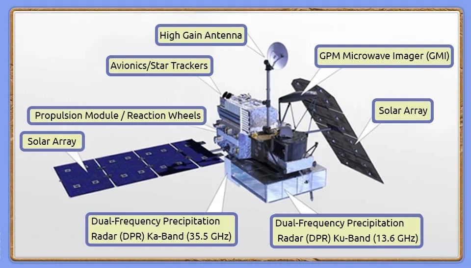
NASA and the Japan Aerospace Exploration Agency are jointly developing the Core satellite, which is the heart of the GPM constellation. The core is equipped with two rain measuring instruments. The first is a dual-frequency (Ka/Ku-band) precipitation radar onboard a GPM satellite developed at the Japan Aerospace Exploration Agency (JAXA) and the National Institute of Information and Communications Technology (NICT), referred to as the DPR. The second device, called the GPM Microwave Imager (GMI), is an advanced, large-aperture, multichannel passive microwave (PMW) rain radiometer (Smith et al., 2004). NASA developed the satellite bus and GPM microwave radiometer, and JAXA developed the DPR. Compared to the Precipitation Radar (PR) and TRMM Microwave Imager (TMI) on TRMM, the DPR and GMI are advanced instruments (Kojima et al., 2021). Rain rates between 0.22 and 110.00 mm/h can be quantified using the DPR, while the GMI measures rain rates between 0.2 and 60.0 mm/h. Both instruments can detect snowfall at different resolutions. The DPR detects snowfall at an effective resolution of 5 km, and the GMI detects snowfall at an effective resolution of 15 km (Skofronick-Jackson et al., 2017).
The GPM Core Observatory is equipped with a vital instrument known as the Dual-frequency Precipitation Radar (DPR), which includes a Ku-band radar (KuPR) as well as a Ka-band radar (KaPR). Operating at 13.6 GHz, the KuPR is an enhanced version of the very successful device that was part of the Tropical Rainfall Measuring Mission (TRMM). The KuPR and KaPR on the GPM spacecraft bus are aligned, resulting in the same 5-km footprint location on Earth. The scientific community benefits from the 3-dimensional rain observations and accurate rainfall rate estimations provided by the KuPR and KaPR units (NASA). In tropical areas, the Ku-band radar in the DPR is specifically designed for heavy rainfall, while the Ka-band radar is more effective for light rainfall in higher-latitude regions. The use of DPR is vital in enhancing rainfall estimation accuracy for constellation satellites (Kojima et al., 2021).
One key advantage of spaceborne radar is its ability to observe precipitation in areas where ground radar data is often not obtainable, like mountainous terrain and open oceans (Hirose et al., 2017). Spaceborne precipitation radars use the received power of the backscattered microwave signal from raindrops to estimate the precipitation rate (Nakamura, 2021). During the winter months, stable environments in mid- to high-latitude mountainous regions often lead to the presence of shallow precipitation clouds, which can result in inaccuracies in spaceborne precipitation radar observations. The detection of shallow orographic precipitation is now possible, as GPM DPR observations cover higher latitudes compared to TRMM PR (Shimizu et al., 2023).
DPR outperforms PR in capturing light rain and snow thanks to the inclusion of Ka-band radar, which leads to a more accurate measurement of the rain drop size distribution (DSD). KuPR and TRMM PR have nearly identical scan patterns. The vertical range resolution for Ku-band and Ka-band radars is 250 m, with samples captured every 125 m. (Liao and Meneghini, 2022). KaPR is equipped with 49 footprints that are divided into two types of scans: 1) the normal mode, called “KaPR for matched scan” (KaMS), and 2) the high-sensitivity mode, called “KaPR with high sensitivity”. In normal mode, KaMS measures 25 pixels per scan. Following the 25-pixel measurements, KaPR measures 24 pixels in high-sensitivity mode. The vertical resolution of the KaHS measurements is lower compared to the KaMS measurements (250m for KaMS and 500m for KaHS), but KaHS has a higher minimum detection level. In the early stages of the mission, the KaHS beams were directed with two normal scans performed in an interleaved manner. There was a modification to the scan pattern of KaHS in May 2018 (Seto et al., 2022).
The primary DPR’s goals are:
To enhance our understanding of precipitation and precipitation intensity at surface (liquid or solid),
Through sensitive observations, the KaPR instrument can detect weak rainfall and snowfall that go beyond the capabilities of the KuPR
Simultaneous observations by the KaPR and KuPR will enable accurate measurements of precipitation, from heavy rainfall in the tropics to weak snowfall in high-latitudes.
To measure Cloud liquid water (CLW), Cloud Liquid Water (CLW) total column
Enabled to measure freezing level height in clouds, melting layer depth in clouds and cloud drop effective radius
To detect Cloud ice, Cloud ice Total Column, Cloud ice effective radius
Along with the advantages mentioned above, DPR also comes with drawbacks like ground surface echoes contaminating the area above, making it less accurate in estimating precipitation over mountainous regions where a high-altitude blind zone (Arulraj and Barros, 2021).(GPM Data Handbook, 2023; WMO OSCAR)
Sensor characteristics, including (GPM Data Handbook, 2023; Liao and Meneghini, 2022; Kubota et al., 2016; WMO OSCAR; NASA):
Table 2. Characteristics of ِDPR Instrument | GPM Instruments | GPM Device
Item | KuPR | KaPR |
Frequencies | 13.597 and 13.603 GHz | 35.547 and 35.553 GHz |
Minimum Measurable Rain Rate | 0.5 mm/h | 0.2 mm/h |
Swath Width | 245 km | 125 km |
Scanning Technique | Electronic scanning, planar array of 148 elements | |
Spatial Resolution | Horizontal 5.0 km (Nadir), vertical 250 m (blind to the lowest ~ 150 m) | |
Range Resolution | 250 m | 250/500 m |
Beam Width | 0.71 deg (Center Beam) | 0.71 deg (Center Beam) |
Minimum detectable radar reflectivities | ||
The Global Precipitation Measurement Mission’s Dual-Frequency Precipitation Radar (DPR) observes precipitation by changing the angle at which it emits microwave signals. Estimation of precipitation rates is done by analysing the radar backscattered power from hydrometeors within the antenna main lobe. Backscattered power from the Earth's surface can play a role in the received signal along the antenna sidelobe (Kubota et al., 2016). In addition to measuring precipitation, DPR measures surface echoes, utilising the latter to estimate the path -integrated attenuation (PIA) in the surface reference technique (SRT). For both KuPR and KaPR, the DPR standard algorithm has been enhanced with a correction method for PIA that considers the impact of soil moisture. After making this correction, the surface precipitation rate estimates for KuPR increased by roughly 18% and for the normal scan of KaPR by 15% over land (Seto et al., 2022). The first step in the operational algorithm for active sensors like the DPR on board NASA’s Global Precipitation Measurement (GPM) mission’s Core Observatory is to determine if its profile has precipitation hydrometeor or not, and then, it determines the existence of a bright band, which is essentially identifying stratiform precipitation. The precipitation rate is retrieved by applying various coefficients, since it is an essential input for the hydrometeor melting model. (Spandan Das et al., 2022)
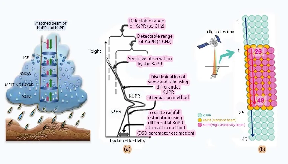
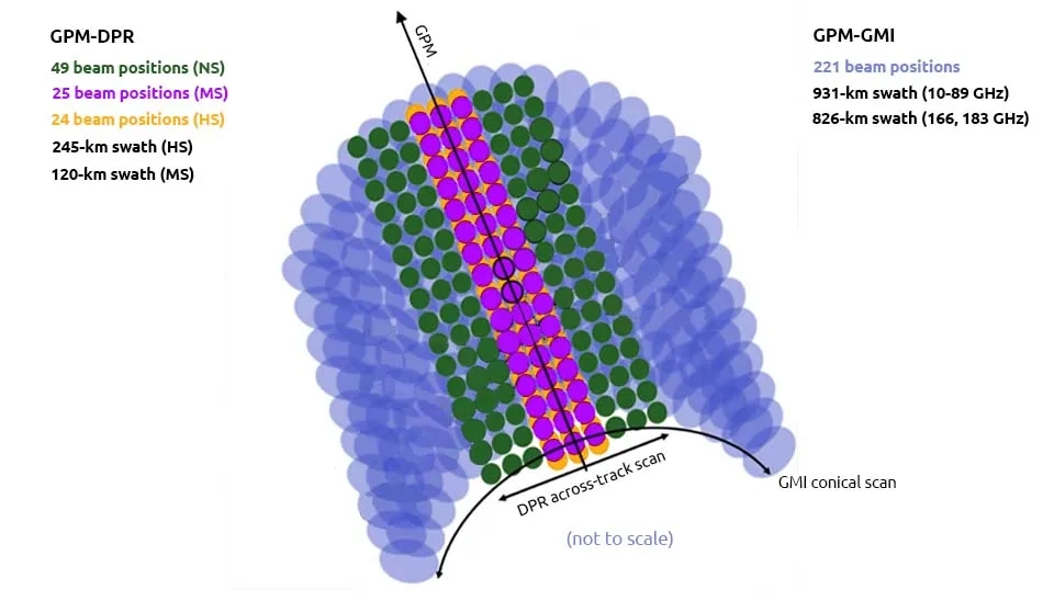
Since the GMI and DPR sensors are both on board the same satellite, it is always possible to determine a collocated GMI's footprint for every DPR pixel, simplifying the process of creating a large quantity of training and validation data records. Nevertheless, it's crucial to recognize the variations in swath width, viewing geometry, and footprint size among them. Figure 6 shows the cross-track scan of DPR, which consists of three modes: high-sensitivity scan (HS; red), normal scan (NS; green), and matched scan (MS; blue). NS and HS correspond to Ku and Ka, respectively, in DPR, with MS serving as the mode for dual-scan. The footprint size is kept at 5 km due to the Nyquist scan design. Correspondingly, there are three sets of precipitation type flag products (Seto et al., 2018).
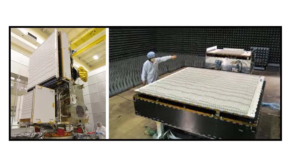
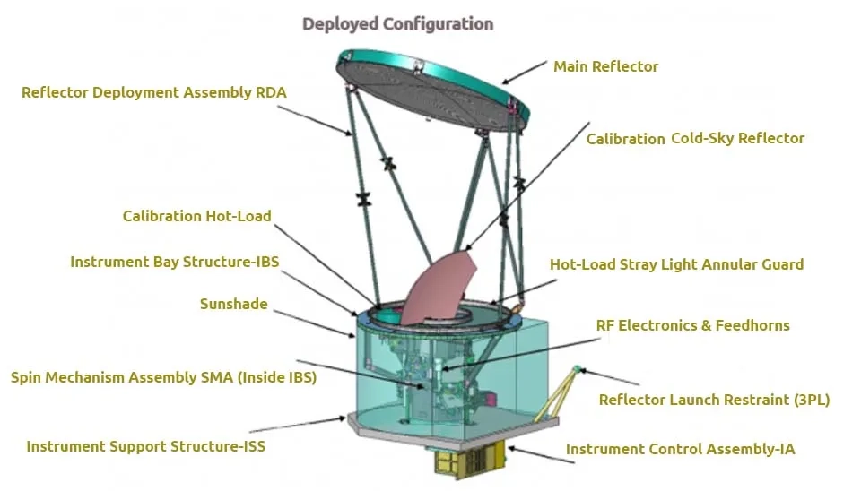
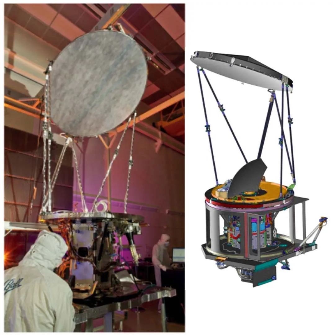
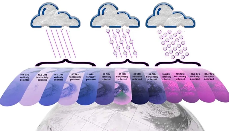
Ball Aerospace and Technology Corporation was chosen by NASA in March 2005 to provide the GMI instrument. The Global Precipitation Measurement (GPM) Microwave Imager (GMI) is a crucial component of GPM and is characterised by a microwave radiometer, multichannel conical- scanning, providing near-global coverage, and frequent revisit time (Bidwell et al., 2005). Thirteen microwave channels in the GMI cover a frequency range of 10 GHz to 183 GHz. Four high frequency channels near 166 GHz and 183 GHz are carried by the GMI, alongside channels similar to those on the Tropical Rainfall Measuring Mission (TRMM) Microwave Imager (TMI). The spatial resolution of the GMI is greatly improved with a 1.2 m diameter antenna compared to the TMI (NASA). Components of GMI are shown in Figure 8.
The GMI was designed with the same earth-incidence angle as the TMI to maintain similar geometry. Collecting microwave radiometric brightness measurements, the GMI will rotate at 32 rotations per minute over a 140 degrees sector centred on the spacecraft's ground track vector. Calibration is carried out within the remaining angular sector, i.e., observation of cold space as well as observation of a hot calibration target. On the Earth's surface, the 140 degrees GMI swath spans 904 km. The GMI swath and DPR swaths only overlap in their central sections, with a 67-second gap between measurements caused by spacecraft motion and geometry. These overlapped measurements play a vital role in enhancing precipitation retrievals, specifically those relying on radiometer-based data (GPM Data Handbook, 2023).
Serving as a transfer standard for the constellation radiometers, the GPM Microwave Imager (GMI) is a key role in the GPM Core satellite. During the development phase and early in the GPM mission, the TRMM Microwave Imager (TMI) played a key role as a transfer standard. Now, the GPM Microwave Imager (GMI) fulfils this role. The stability of GMI seems highly reliable, and a physically based calibration has been developed that appears accurate at or better than 1K (Wilheit et al., 2015). The GMI sensor measures precipitation intensity at surface (liquid or solid), sea-ice cover, and wind speed (near the surface) (WMO OSCAR).
Sensor characteristics, including (GPM Data Handbook, 2023; WMO OSCAR):
Table 2. Characteristics of GMI Instrument | GPM Instruments | Global Precipitation Measurement Instruments | GPM Device
Item | GMI |
Full Name | GPM Microwave Imager |
Background | Evolution of TMI on TRMM |
Frequencies | 10.65 GHz (V/H), 18.7 GHz (V/H), 23.8 GHz (V), 36.5 GHz (V/H), 89.0 GHz(V/H), 165.5 GHz (V/H), 183.31 ± 3 GHz (V), 183.31 ± 8 GHz (V) |
Horizontal Resolution | 6 to 26 km |
Swath Width | 904 km |
Scanning Technique | Conical: 53° zenith angle; useful swath: 850 km - Scan rate: 32 scan/min = 13.4 km/scan |
Spatial Resolution | Changing with frequency, consistent with an antenna diameter of 1.2 m (only partially illuminated at higher frequencies) |
Scan Interval | 1.875 sec |
Design life |
Wide-swath brightness temperatures (Tb) data from the GMI can be employed to estimate surface precipitation at resolutions ranging from 5 to 25 km, depending on frequency, covering a span of 885 km. The motivation behind GMI development was to build databases supporting Bayesian microwave precipitation retrieval algorithms (Kummerow et al., 2015), Additionally, it will serve as a reference radiance calibration standard for the GPM constellation (Hou et al., 2014).
Alternatively: The GPM-GMI Radiometer Precipitation Profiling (GPROF) product does not currently include precipitation type, but research suggests that grouping according to weather systems or atmospheric stabilities (e.g, Convective available potential energy (CAPE)) could enhance the retrieval of precipitation rate (Petković et al., 2018; Henderson et al., 2017).
Successfully launched in February 2014, the core satellite of NASA and the Japan Aerospace Exploration Agency Global Precipitation Measurement marks a significant achievement. The GPM core satellite has a dual-frequency precipitation (DPR) radar that operates at both Ku (13.6 GHz) and Ka (35.5 GHz) bands, along with a multifrequency microwave radiometer (GMI). The DPR's dual-frequency capability is expected to enhance our understanding of precipitation processes, providing more detailed microphysics information and improved accuracy in rainfall retrievals compared to the single-frequency (Ku band) radar used in Tropical Rainfall Measuring Mission (TRMM). The GMI is more advanced compared to the TMI and features new high-frequency channels (166 GHz and 183 GHz) necessary for detecting snowfall. The GPM satellite's DPR and GMI can offer global, high-resolution precipitation data for various applications in meteorology, hydrology, and water-resources management. The combination of DPR and GMI creates a new calibration standard for microwave sensors in low-Earth orbit, enhancing GPM's ability to measure light and solid precipitation.
15.46 dBZ
19.18, and 13.71 dBZ for the KaMS, and KaHS, respectively |
Transmitter | 128 Solid-State Amplifiers | 128 Solid-State Amplifiers |
Peak Transmit Power | 1013 Watts | 146 Watts |
Pulse Repetition Frequency | 4000 to 4500 Hz | 4000 to 4500 Hz |
Pulse Width | Two 1.6 micro sec pulses | Two pulses of 1.667 microseconds each in aligned beams, and two pulses of 3.234 microseconds each in alternating scans |
Beam Number | 49 | 49 (25 in matched beams and 24 in interlaced scans) |
Beam Matching Error | Under 1000 m | |
Observable Range | 19 km to surface (to –5 km near nadir) | |
Receiver Power Accuracy | ±1dB | |
Scan Angle (in observation mode) | ±17° Cross Track | ±8.5° Cross Track |
Beam Width | 14 MHz | |
Antenna Size | 2.5 × 2.4 × 0.6 m | 1.4 × 1.2 × 0.8 m |
Max. Mass | 472 kg | 336 kg |
Power (max) | 446 W (orbit average) | 344 W (orbit average) |
Science Data Rate (max) | 109 kbps | 81 kbps |
Housekeeping Data Rate (nominal) | 1 kbps | 1kbps |
Utilization Period | 2014 to 2026 | |
Coverage / Cycle | 65° covered ,Nearly-global in 5 days | |
3 years and 2 months
Data Rate | 25 kbps |
Weight | 150 kg |
Power Consumption | < 141 W |
Dimensions (diameter of antenna) | 1.2 m |
Coverage / Cycle | Near-global coverage in 2 days/ high latitudes (> 70°) not covered. |
Utilization Period | 2014 to 2026 |
Quick answers to common questions.
Keep reading


Comments
No comments yet
Be the first to comment
Share your thoughts and start the conversation.