The Tropical Rainfall Measuring Mission (TRMM) Satellite
How can we measure rainfall in hard-to-reach areas, and what innovative methods address accessibility challenges?
FFarideh
· 20 min read· 13 views

How can we measure rainfall in hard-to-reach areas, and what innovative methods address accessibility challenges?
Quick answers to common questions.
How can we measure rainfall in hard-to-reach areas, and what innovative methods address accessibility challenges? To what extent do satellites play a crucial role in transforming rainfall measurement, especially in traditionally inaccessible regions? How does advanced satellite technology contribute to expanding our knowledge of rainfall patterns in meteorology?
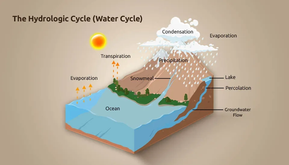
Precipitation plays a vital role in the global water cycle and energy cycle that governs the climate, weather, and ecosystems and significantly impacts our daily lives. To understand global water flux cycling and the energy balance of the Earth's system, it is crucial to have detailed knowledge of precipitation intensity and accumulation (Hou et al. 2014). Ground-based rain gauges are traditionally used to measure rain, but the lack of extensive networks is evident in vast ocean areas, tropical rain forests, and high mountain regions. Where measurements are made, they might not provide an accurate representation of the rainfall across the entire area (Kidd et al. 2017). The Tropics, being mostly covered by the ocean (approximately 75%), require space-based measurements for accurate precipitation data. (Kummerow et al., 1998). Today, remote sensing has helped a lot in this direction. One of the most important satellites is the Tropical Rainfall Measuring Mission (TRMM).
The TRMM is a joint space mission between NASAD of Japan and NASA of the USA and is designed for an operational term of at least three years (Simpson et al. 1988). The objective of the TRMM is to observe rainfall and energy exchange in tropical and subtropical regions of the world (Kummerow et al., 1998) The observations began in 1997, and the mission continued for more than 17 years.
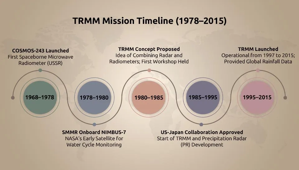
Motivation and History of TRMM
Year | Event |
1968-1978 | Launch of COSMOS-243 as the first spaceborne A microwave radiometer was developed by the Soviet Union for Earth observation. |
Launch of the Scanning Multichannel Microwave Radiometer (SMMR) onboard the NIMBUS-7 satellite | |
1978-1980 | NASA has been working on a high-altitude aircraft program since 1979, with the goal of studying cloud and precipitation properties for space-based studies of earth system science. |
1980-1985 | The idea of using a combined instrument complement of passive and active microwave (radar) instruments for measuring rainfall from space |
holding a workshop entitled ‘’ Precipitation Measurements from Space’’ in the US | |
"Tropical Rain Measuring Mission" proposal was submitted to NASA Headquarters by a team of Goddard investigators | |
Japan-US joint satellite project was proposed by NASA | |
1985-1995 | SSLG approved a Japan-US joint mission. |
A feasibility study was performed. | |
The development of the TRMM PR model began in 1988 and continued until 1993. | |
NASA initiated TMI, VIRS, CERES, and LIS development. | |
1995-2015 | TRMM was launched |
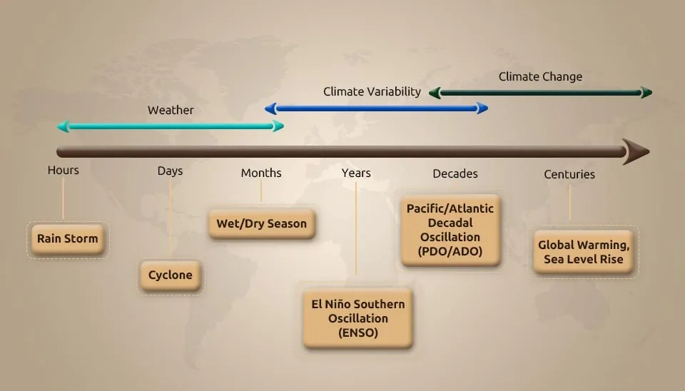
The dependency of ecosystems, the Earth system, and human society on precipitation is crucial (Kidd et al. 2017). The socioeconomic impacts of extreme precipitation events caused by blizzards, hurricanes, droughts, floods, and landslides are significant (NRC, 2010). Climate variability, on a global and regional scale, is heavily impacted by precipitation, clouds, and water vapour mass exchanges (Ramanathan et al., 2001). The temporal dimensions of weather and climate phenomena are very wide and include various phenomena that are shown in Figure 2.
Based on dynamic and cloud microphysical mechanisms, precipitation is commonly categorized as stratiform or convective (Houze, 1997). However, previous research mainly focused on frequency, total amount, and intensity due to observed data constraints (Liao et al., 2023). Stakeholders' decision-making at the local scale necessitates precise and dependable precipitation products with higher temporal and spatial resolution due to the wide variety of precipitation in place and time (Paschalis et al. 2014).
When estimating precipitation over extended areas, rain gauges on land encounter representativeness issues, particularly at fine temporal resolutions or in complex terrain. In mountainous regions, radars face challenges such as propagation errors, beam blockage, and imprecise rain rate measurements. Comprehensive global precipitation data can only be obtained from space due to limited land surface instrumentation and impractical oceanic measurements (Kidd and Levizzani 2011). Compared to rain stations that observe the surface, measuring precipitation values is more effectively done by satellites due to several of their advantages (Tan, 2019). These include a) climate impacts; b) continuous recording; c) high temporal and spatial resolution; d) wide coverage area; e) less field variability; f) near real-time data; g) fast access; and h) free downloads (Santos et al., 2019; Nurhamidah et al., 2023). There are currently several satellite-based precipitation products, such as: Global Satellite Mapping of Precipitation (GSMaP) (Ushio et al. 2009), Climate Prediction Center (CPC) morphing algorithm (CMORPH) (Yang et al. 2021), Global Precipitation Climatology Project (GPCP), Precipitation Estimation from Remotely Sensed Information using Artificial Neural Networks (PERSIANN) (Zhao et al. 2017), Tropical Rainfall Measuring Mission (TRMM), Multi-satellite Precipitation Analysis (TMPA) (Huffman et al. 2007).
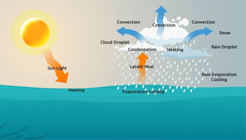
The atmosphere derives three-fourths of its thermal energy from the release of latent heat by precipitation, and according to estimates, two-thirds of this precipitation occurs in the Tropics between 30° North and 30° South. Long-standing knowledge exists regarding the contribution of latent heat from tropical precipitation to low-latitude circulations and the energy needed to counteract radiative heat losses. It has been proposed and validated that "hot towers" play a significant role in the equatorial belt. The occasional eastward migration of tropical hot towers in the Pacific basin hinders global progress in understanding ENSO. Lack of knowledge about tropical precipitation hinders progress in understanding ENSO and predicting associated climatic changes. (Simpson et al., 1988). TRMM is renowned for measuring precipitation in the oceans and tropics (Huffman et al. 2010).
Japan was involved in the development of the TRMM concept from the beginning, and the country joined the programme right away (Kummerow et al. 2000). The proposed instruments included a microwave radiometer, a VIS/IR radiometer, and a rain radar. In the eventual agreement, it was defined that the US would supply the satellite bus,the microwave radiometer (TMI), and the Visible Infrared radiometer (VIRS), and Japan (CRL, Communications Research Laboratory (currently named NICT, National Institute of Information and Communications Technology), and JAXA) would provide the precipitation radar (PR) and the launch service. The US later added two Earth Observing System (EOS) instruments: the Clouds and Earth's Radiant Energy System (CERES) and the Lightning Imaging Sensor (LIS). Through its observation of tropical and subtropical regions, TRMM furnished essential data on rainfall and heat release, which play a pivotal role in driving global atmospheric circulation and shaping weather patterns and climate (Tomomi Nio et al. 2015).
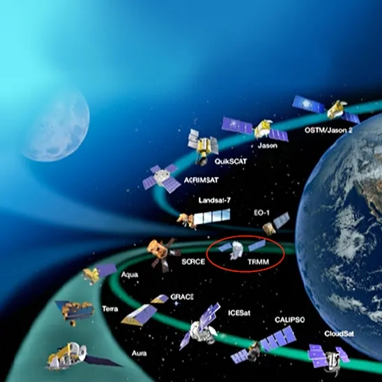
By collaborating with other satellites, TRMM provided valuable precipitation data, improving our knowledge of how water vapor, clouds, and precipitation are interconnected, which is crucial for maintaining Earth's climate (NASA).
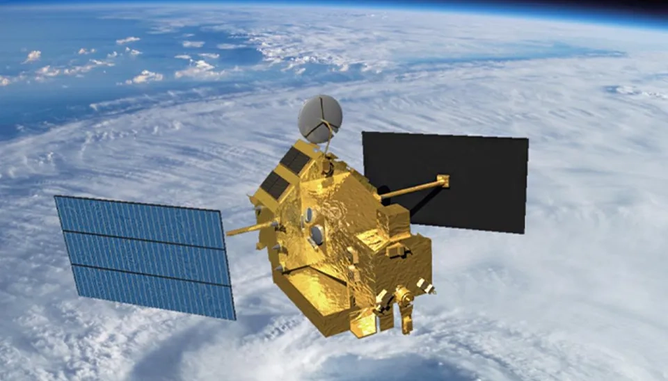
Table 2. TRMM summary
Launch Date | November 27, 1997 |
End-of-life Date | April 8, 2015 |
Mission Duration | 17 years |
Status | Mission Complete |
Successor after TRMM | The Global Precipitation Measurement (GPM) |
Agency | the National Aeronautics and Space Administration (NASA) of the United States and the National Space Development Agency (NASDA) of Japan |
Measurement Category | Atmosphere, Land, and Ocean |
Instrument | TMI, PR, VISR, CERES, LIS |
Weight | Total: 3620 kg [3524 kg] Fuel: 890 kg Dry weight: 2730 kg [2634 kg] |
Electric power (W) | Approx. 1100 W [Ave. 850 W] |
Attitude control | Zero-momentum, three-axis stabilized |
Data transmission | via TDRS 32Kbps (Real Time), 2Mbps (Playback) |
The responsibilities of the US and Japan related to the development and S/C (spacecraft) operations are as follows (Tomomi Nio et al. 2015):
Japan (CRL and NASDA) provided the Precipitation Radar (PR) and the launch of the TRMM satellite by an H-II rocket, as well as the data system.
US (NASA) provided the spacecraft bus, TRMM Microwave Instruments (TMI), Visible and Infrared Radiometer System (VIRS) instrument, Clouds and Earth’s Radiant Energy System (CERES) instrument, and Lightning Imaging System (LIS) instrument. Utilizing Tracking and Data Relay Satellites (TDRS), NASA/Goddard Space Flight Centre (GSFC) manages the on-orbit spacecraft operation.
The main scientific objectives of the Tropical Rainfall Measuring Mission (TRMM) include the following studies (Chiu et al. 2006; Simpson et al., 1999; Keating and Ryan, 2012):
The goal is to obtain and study multiyear science data sets of tropical and subtropical rainfall measurements to help model and predict how the interaction between the sea, air, and land masses produces changes in global rainfall and climate.
Enhancing modeling of tropical rainfall processes and their impact on global circulation for accurate rainfall prediction at different time scales
We aim to enhance our comprehension of the balances and mechanisms of our physical climate system, specifically regarding the distribution of precipitation and infrared latent heat release.
To understand spatial and temporal variations of tropical rainfall and their influence on global circulation to predict rainfall and improve modeling of these processes
The aim is to test, evaluate, and improve the rainfall measurement techniques of space-based systems.
Highly accurate temporal-spatial and long-term precipitation data are essential for researching climate change, hydrologic simulation, natural hazards, and water resource management, as these phenomena are influenced by their temporal and spatial variability (Zhao et al. 2017). Some of the TRMM applications are included as follows (Adler Robert, 2005; Zhao et al., 2017 ; Nurhamidah et al., 2023; NASA):
Water Management
Agriculture
Climate change forecasting
hydrological process modeling
Ecology
Air Quality
Energy Management
Aviation
Disaster Management
Public Health
Determining Tropical Cyclone
Also, the TRMM satellite is of tremendous help in extreme weather studies and operational applications, which are briefly discussed below.
The Goddard Earth Sciences Data and Information Services Centre (GES DISC) provides such support through the following services :
GES DISC provides a way to monitor global droughts and floods (Amini et al. 2019; Yuan et al. 2019).
Zhong Liu et al. (2012) are studying the impact of rainfall on crop moisture and toxins to understand the environmental causes of diabetes.
TRMM data help to perceive, recognize, and predict the El Niño and Southern Oscillation (ENSO) (Liang and Wang, 2020).
Development of a rainfall-based crop insurance product for developing countries (Zhong Liu et al. 2012).
In 2004, TRMM data were used 669 times for determining tropical cyclone location fixes (Adler Robert, 2005).
Meteorologists have studied rainfall patterns over the land for decades using ground-based radar, specialized aircraft instruments, and weather ground stations. Satellites provide exceptional measurements over the Earth, whereas standard ground-based instruments lack visibility. We describe the history of the first spaceborne TRMM as follows:
In 1968, the Soviet Union launched COSMOS-243, the first spaceborne microwave radiometer for Earth observation (Nakamura, 2021).
In 1972, the US led the way in measuring precipitation from space using microwave radiometers, such as the Electrically Scanning Microwave Radiometer (ESMR) onboard the NIMBUS-5 (Wilheit et al., 1976; Wilheit et al., 1977).
the Scanning Multichannel Microwave Radiometer (SMMR) onboard the NIMBUS-7 satellite was launched in late October 1978 (Wilheit and Chang 1980).
Since 1979, NASA has worked on a high-altitude aircraft programme with the goal of studying cloud and precipitation properties for space-based studies of earth system science (Simpson et al., 1988).
The Communications Research Laboratory (CRL) created an airborne dual-frequency radar system for measuring rain in 1980. This project was the initial phase of designing a rain radar for space (Okamoto et al., 1982). The experiments showed the usefulness of simultaneous radar and microwave radiometer observations of rain. This design concept could be used in the TRMM mission definition (Okamoto et al., 2003).
In 1981, the National Aeronautics and Space Administration (NASA) and the National Oceanic and Atmospheric Administration (NOAA) held a workshop in the US titled "Precipitation Measurements from Space" to persuade NASA's headquarters to launch a new precipitation measurement programme. The workshop report was described by Atlas and Thiele in 1981.
By September 1984, a team of investigators from the Goddard Space Flight Centre submitted the “Tropical Rain Measuring Mission” proposal to the NASA team. Japan's Communication Laboratory then joined in the activities soon thereafter. Joint aircraft flights with an experimental radar (Meneghini et al., 1992) suggested that instrument accuracy was promising (Kummerow et al., 2000).
After a series of airborne experiments conducted in Japan, a joint experiment to study "the feasibility of measuring rain from space" was initiated in 1985 between CRL and National Aeronautics and Space Administration/Goddard Space Flight
Center (NASA/GSFC). This cooperative experiment was critical in bringing about what later was to be called the joint U.S.-Japan TRMM (Okamoto, 2003).
The development of the proposed TRMM future began with a major workshop near Goddard in November 1985. Many different types of radars were suggested, along with a conically scanning passive microwave instrument like SSM/I, a single-frequency cross-track scanning radiometer to work with the radars, and a visible/infrared radiometer like the advanced very high-resolution radiometer. The visible/infrared instrument aimed to connect TRMM with operational geostationary platforms, essentially functioning as a "flying rain gauge" (Kummerow et al., 2000).
The science steering group of TRMM, formed after the November 1985 meeting, released a report outlining the mission's science priorities in 1986. These goals are presented as follows:
To help understand, diagnose, and predict the onset and development of the El Niño Southern Oscillation and the propagation of the 30- to 60-day oscillations in the Tropics.
The aim is to advance the objective of the earth science system to understand the global energy and water cycles by providing a distribution of rainfall and latent heating over the global tropics.
The goal is to allow cross-calibration between TRMM and other sensors with life expectancies beyond those of TRMM itself.
To understand the mechanisms through which changes in tropical rainfall influence global circulation and to improve the ability to model these processes to predict global circulations and rainfall variability at monthly and longer timescales
The aim is to evaluate the diurnal variability of tropical rainfall globally.
The goal is to provide rain and latent heating distributions to improve the initialization of models ranging from 24-hour forecasts to short-range climate variations.
To help understand the effect that rainfall has on the ocean's thermohaline circulations and the structure of the upper ocean
The objective is to evaluate a space-based system for rainfall measurements.
The Japanese Space Commission accepted the invitation to jointly investigate the viability of TRMM in 1986.
In January of 1987, a feasibility study was performed. After that, development of the TRMM precipitation radar (PR) began (Okamoto, 2003).
In 1991, the project got underway formally with VIRS, TMI, CERES, and LIS development by NASA and PR development starting by NASDA.
In 1994, the United States and Japan chose new science teams, and a Joint TRMM Science Team was created to coordinate their efforts until TRMM was launched (Kuerrow et al. 2000).
It was scheduled to be launched in the summer of 1997, with a mission life of at least 3 years. The Tropical Rainfall Measuring Mission (TRMM) satellite was launched on November 27, 1997, and data from all the instruments first became available approximately 30 days after the launch (Kumerow et al. 2000). The TRMM mission life was planned for three years and two months after launch in January 2001. Over the planned mission life, the satellite condition was good, and the mission operation period was extended. The satellite altitude was raised to 400 km from 350 km in August 2001.
In 2011, because of the retirement of the space shuttle, the International Space Station (ISS) altitude increased from 350 km to 400 km. So, the ISS and TRMM flew in roughly the same orbit until the end of their missions. TRMM and ISS agreed not to allow any near misses between the two vehicles. TRMM and ISS flew satisfactorily until the RMM mission was completed (Tomomi Nio et al. 2015).
Finally, TRMM officially ended on April 15, 2015, after the spacecraft depleted its fuel reserves. TRMM was turned off and re-entered Earth on June 16, 2015, over the South Indian Ocean. Originally designed for 3 years, TRMM continued to provide groundbreaking 3-D images of rain and storms for 17 years (JAXA).
TRMM has four mission phases, each with specific standards and objectives. The operational life cycle of TRMM starts with the pre-launch initial planning stage, and then after the orbital mission operation, ends with the ocean disposal of the TRMM observatory. These phases are described as follows (TRMM Data Users Handbook, 2001; Tomomi Nio et al., 2015):
Ground part installation, testing, and flight operations planning are the main activities during the pre-launch planning and testing phase. Final inspection, checkout, and launch site operations are part of this phase.
With the launch, this phase begins and includes launch and in-orbit checkout. The key activities include TRMM launch, orbit injection/stabilization, turning the instruments on, satellite checkout, descent to mission altitude, and calibration, which takes around 60 days (Tomomi Nio et al., 2015).
The main mission operations phase, known as the normal mission operations phase, lasts for a minimum of three years and involves collecting science data. It consists of two steps: the normal operation phase, which lasts for 3 years and 2 months, and the post-operation phase that follows.
The final phase of the mission is the ocean disposal phase. TRMM's normal operation is primarily concerned with maintaining its orbit. TRMM carried around 890 kg of hydrazine during the launch. The mission ends when the fuel level drops to about 58 kg. At that point, controlled reentry is conducted using the attitude control and propulsion subsystems. TRMM is now in this stage.
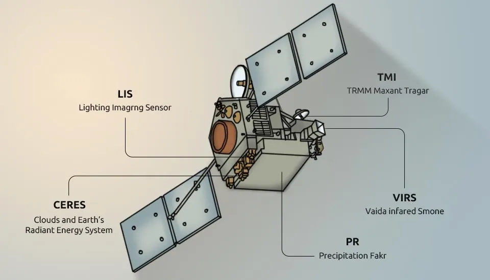
The primary rainfall instruments on TRMM are the TRMM Microwave Imager (TMI), the Precipitation Radar (PR), and the Visible and Infrared Radiometer System (VIRS). Additionally, the TRMM satellite will carry two related Earth Observing System (EOS) instruments: the Clouds and Earth’s Radiant Energy System (CERES) and the Lightning Imaging System (LIS). The observation principle and the swath width of each sensor are different from each other. PR looked through the precipitation column and gave fresh information about tropical storm structure and intensification. TMI measured the microwave energy emitted by the Earth and its atmosphere to quantify the water vapour, the cloud water, and the rainfall intensity in the atmosphere (NASA).
The TRMM, using its instrument, measures various things over Earth. The mission measurement category is briefly presented as follows (CEOS EO Handbook):
Atmosphere:
Cloud type, amount, and cloud top temperature (VIRS)
Cloud particle properties and profile (PR, TMI)
Atmospheric Humidity Fields (TMI)
Atmospheric Winds (PR)
Liquid water and precipitation rate (PR, TMI)
Lightning Detection (LIS)
Radiation budget (CERES, VIRS)
Land:
Soil moisture (TMI)
Ocean:
Multi-purpose imagery (ocean) (VIRS)
Ocean Ocean surface winds (TMI)
Surface temperature (ocean) (TMI)
There are five instruments onboard the TRMM satellite, and three of them are used for precipitation (Chiu et al. 2006).
Infrared (IR) images are used in various techniques to estimate precipitation. In estimating precipitation, higher cloud tops are a reliable indicator for convective clouds, which are the primary contributors to tropical and global precipitation (NASA).
To calculate rainfall rates from TMI, complex calculations based on Planck’s radiation law are required. Water surfaces appear cold to a passive microwave radiometer, while raindrops appear warm, offering a noticeable contrast. As raindrops increase, the scene becomes warmer, and advancements in research now allow for fairly precise rainfall rate calculations based on microwave scene temperature (NASA).
While instruments like the TRMM Microwave Imager (TMI) and the Visible and Infrared Scanner (VIS) VIRS have been used in space before, the Precipitation Radar on TRMM is the first radar specifically designed for measuring rainfall in space.
The ability to provide vertical profiles of rain and snow up to 12 miles (20 kilometres) is one of the most important features of its PR (NASA).
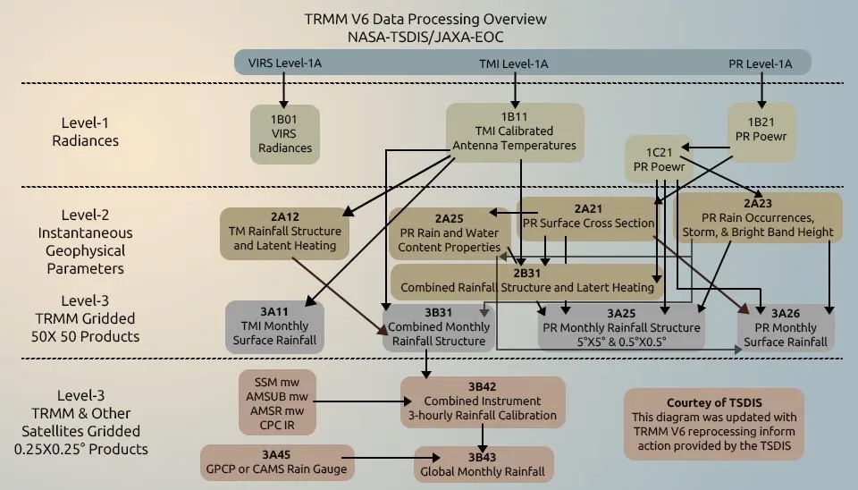
NASA and NASDA process TRMM-observed data at different levels and distribute it to users. The following shows the definition of TRMM at different levels (NASA, 2011):
Level 0: Consists of data units that were received during multiple acquisition sessions. This level includes unprocessed data from instruments that is arranged in chronological order, validated for quality, and free of redundancy. The consumer can receive it within 24 hours after receiving the final source data unit for the routine production data set.
level 1: Level 0 data is accompanied by ancillary and georeferencing data, which are then converted to sensor-specific physical units (e.g., radar reflectivity, brightness temperature). This level includes levels 1A, 1B, and 1C.
Level 2: Consists of geophysical parameters that are derived at the same resolution and location as the Level 1 data. Different algorithms will utilize Level 1 data to calculate meteorological parameters, resulting in a 2- or 3-dimensional rain map along the TRMM swath. The rain map consists of the 2B combined product, 2A radar data, and 2A radiometer data.
level 3: Results of mapping the meteorological parameters (Level 2) on a uniform space and time grid The results consist of the 3B combined system, the 3A radar, and the 3A radiometer.
The designations of the TRMM satellite algorithms and the contents of the corresponding products are described in Simpson et al., 2000 and Kummerow et al.2000.
The processing of PR, TMI, and VIRS data at GSFC includes both raw data and higher-level analysis. Langley Research Center, EOSDIS DAAC and the Marshall Space Flight Center of NASA received Level 0 processed CERES and LIS data. Japan also received PR Level 0 data from PPS, which will be processed further at the JAXA Earth Observation Center (EOC). produced higher level products (Level 1-3 products) by EOC or GSFC/PPS will be distributed to users, which include many scientists in the fields of hydrology, climatology, meteorology, etc. (Tomomi Nio et al. 2015).
Figure 7 shows the TRMM satellite product processing diagram (Chiu et al. 2006).
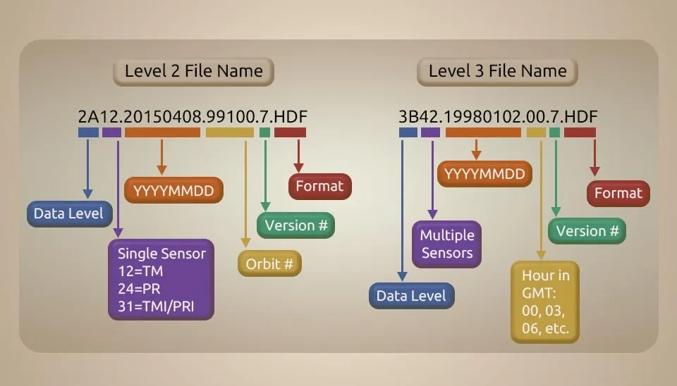
In this section, explain how to name the TRMM file. For example, Level 2 TRMM data is named 2A12.20150408.99100.7.HDF. Respectively, 2A shows data level, 12 means used sensor (12=TM, 24=PR, 31=TMI/PR), 20150408 shows measured date (2015=year, 04=month, 08=day), 099100 means orbit number, 7 refers to version number, and HDF refers to file format.
The naming of level 3 data is slightly different from level 2 data. For example, 3B42.19980102.00.7 HDF, respectively, is defined this way: The components of the identifier are as follows: 3B represents the data level, 42 indicates multiple sensors, 19980102 denotes the date, 00 specifies the hour in GMT (00, 03, 06, etc.), 7 signifies the version number, and HDF refers to the file format (NASA).
Since TRMM was launched, several data services have been developed and applied at the GES DISC. In particular:
Discussions commenced immediately after the authorization of the TRMM project, focusing on its successor. The primary aim of the successor was to broaden coverage to mid- and high latitudes, proposing a dual-frequency precipitation radar and a microwave radiometer with extra high-frequency channels as necessary instruments. The discussion regarding a successor to the TRMM evolved into a constellation system featuring a core satellite that serves as a standard reference for precipitation measurement, along with several other satellites that provide high sampling frequency (Hou et al. 2014). In 2014, the Global Precipitation Measurement (GPM) became a reality. As initially suggested, the GPM core observatory carries a Dual-frequency Precipitation Radar (DPR) and a GPM Microwave Imager (GMI) (Nakamura et al. 2021).
The TRMM operation was successfully concluded and exceeded its design goal by collecting 17 years of rainfall data and facilitating the study of precipitation measurement technology from space and global precipitation system climatology. The field of precipitation science primarily relied on ground observations to study precipitation before the introduction of TRMM. These observations were confined to local scales and didn’t cover vast oceanic areas, tropical rain forests, or high mountain regions. TRMM provided accurate rain distributions over tropical and subtropical districts for science. Despite limited coverage in tropical regions, TRMM partially addressed these limitations. All instruments were operated as expected. TRMM's rain radar in space demonstrated the value of radars in this field. By combining it with other rain observation instruments, scientists were able to calibrate and develop multi-satellite rain maps with TRMM as the reference standard. The TRMM satellite stopped collecting data on April 15, 2015. The TRMM satellite produced over 17 years of valuable scientific data. The TRMM dataset set the standard for measuring precipitation from space and sparked research that enhanced our comprehension of tropical cyclone structure and development, the properties of convective systems, the relationships between lightning and storms, climate and weather modelling, and the impact of human activities on rainfall. The data also provided support for practical uses such as monitoring floods and droughts, as well as forecasting weather.
Satellite altitude was raised to 400 km from 350 km in August 2001. |
TRMM was turned off and re-entered Earth on April 8, 2015, over the South Indian Ocean. |
Orbit | Circular, non-sun-synchronous, with an inclination of 35 degrees to the equator and a precession period of about 46 days for the orbit nodes with respect to the sun (affecting the time of day of sampling at different latitudes). |
Orbit Altitude | 350 km +/- 6 km (11/27/1997–8/6/2001, before orbit boost) |
403 km +/- 6 km (8/24/2001 - 7/15/2014, boost in TRMM's altitude) |
Orbit inclination | 35 deg |
Spatial resolution | 25 km |
Temporal resolution | 3 hourly |
Satellite stationed | 35°N and 35°S of the equator |
Mission duration | 17 years |
Launcher | H-II Rocket |
Launch location | Tanegashima Space Center, Japan |
Project Scientist(s) | Scott Braun |
orbits Period | 90 minutes |
Keep reading


Comments
No comments yet
Be the first to comment
Share your thoughts and start the conversation.