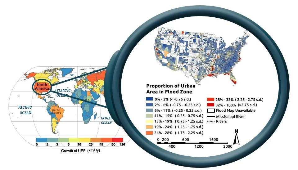
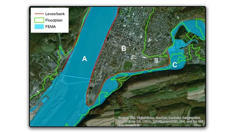
Do you believe that 92,233 square kilometers of global urban areas are at risk of urban flooding? Look at Figure 1. About 25 million people of the US population (about 8.3% of the total population) live in areas that are prone to flooding. As shown in Figure 1, urban areas located in coastal areas (especially in the southeastern United States) have a greater risk of urban flooding. The challenge of urban flooding is not limited to the United States; it covers many urban areas around the world (Qiang et al., 2017). The long-term study of flood-prone urban areas shows that, in recent decades, urban areas are more and more at risk of flooding. The flood-prone urban areas reached 92.2 million square kilometers in 2018, up from 16.4 million square kilometers in 1985. In other words, 2.3 million square kilometers are added to flood-prone urban areas every year. The increase in flood-prone urban areas on the continents of Asia, Europe, and North America had the largest share of 74.1%, 11.6%, and 8.7%, respectively. Among the countries, China and America account for 61.5% of urban areas that are prone to flooding (Cao et al., 2022). Considering that the major increase in flood-prone urban areas in recent decades has been accompanied by climate change and the growth of urban areas in high-risk regions, it is expected that urban areas will be at risk of flooding in the coming decades. Therefore, it is necessary to adopt sustainable approaches to deal with the risk of urban flooding, which requires urban flood modeling.
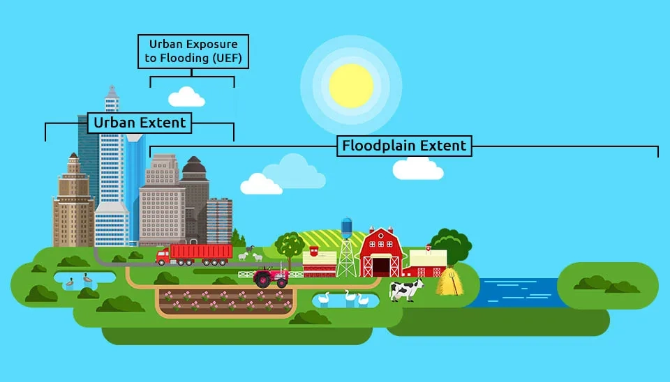
Fig. 1. Urban Exposure to Flooding (UEF) is the overlap between urban extent and floodplain extent.
Table 1. Strengths and Weaknesses of Methods for Urban Flood Modeling
Methods for Urban Flood Modeling
Strengths
Weaknesses
Drainage Network Modeling of Urban Floods
Urban Stormwater Runoff
Temporal and Spatial Analysis
Flow Hydrograph in Drainage Network System
Simplified One-Dimensional Flow
Computational Costs and Demands
Limited Representation of Hydraulic Urban Features
Hydrogeomorphic Floodplain Models for Urban Areas
Computational Efficiency
Large-Scale Analysis
Low Sensitivity for Time Series Data
Lack of Detailed Flow Dynamics
Low Accuracy in an Altered Geomorphic Condition
Shallow-Water Models for Urban Area
Detailed Information
High-Resolution Urban Inundation Simulation
Dynamic Urban Inundation Simulation
Simplified Vertical Dimension
Computational Costs and Demands
Data-Driven Approaches for Urban Flood Modeling
Computational Efficiency
Spatial and Temporal Analysis
Incorporation of Multiple Factors
High-quality and Abundant Data Requirements
Black Box Nature
Ignoring Physical processes
Cellular Automata Urban Modeling
Simplicity
Computational Efficiency
Large-Scale Analysis
Lack of Detailed Flow Dynamics
Limited Performance Evaluation for 1D and 2D Flow
Fig. 2. USA urban areas at risk of urban flooding (Qiang et al., 2017; Cao et al., 2022)
1. Importance of Urban Flood Modeling
Urban flooding (or urban inundation) is a phenomenon that causes significant damage to various aspects of people's lives and affects economic and environmental conditions. The result of urban flooding can be tangible and direct, create an indirect and tangible disruption in economic and business plans, and be intangible to society (such as endangering people's physical and mental health). Climate change and excessive social and economic development, on the one hand, have a significant impact on urban flooding. Therefore, urban resilience against floods has been the focus of researchers, specialists, and decision-makers in the following years to prevent its aggravation with the structure of cities' resilience against floods(Hammond et al., 2013).
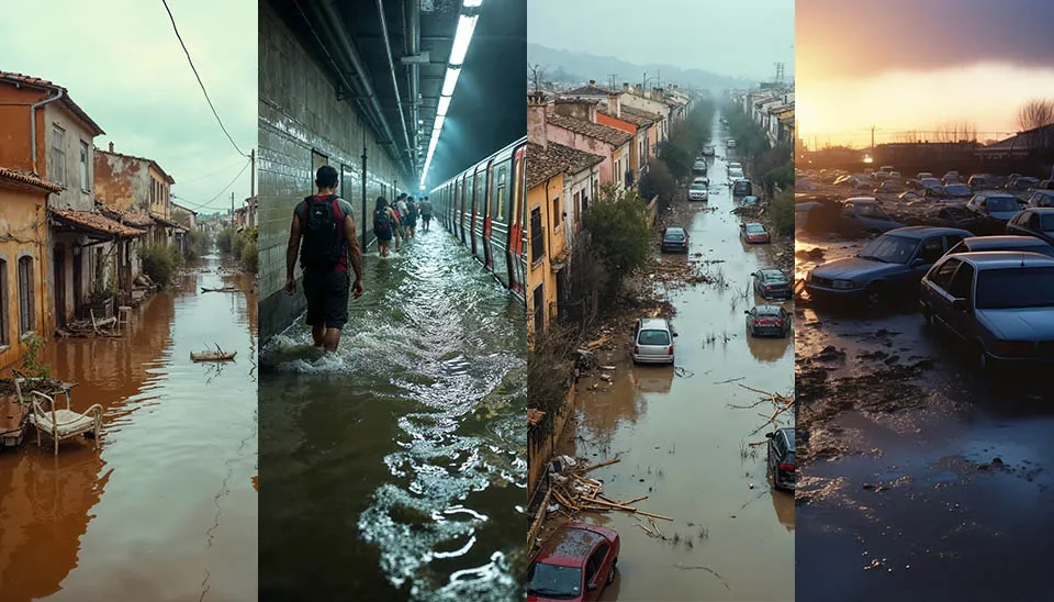
Fig. 3. Heartbreaking images of urban flooding, highlighting the destruction and displacement caused by these events
Achieving the goal of urban resilience and effective urban flood management requires knowledge of urban flood modeling methods in order to prevent the effects of urban flooding by simulating the dynamic processes of urban flooding. Therefore, the accurate evaluation and modeling of urban floods provide the possibility of understanding, evaluating, and predicting floods and reducing the damages caused by urban floods (Qi et al., 2021).
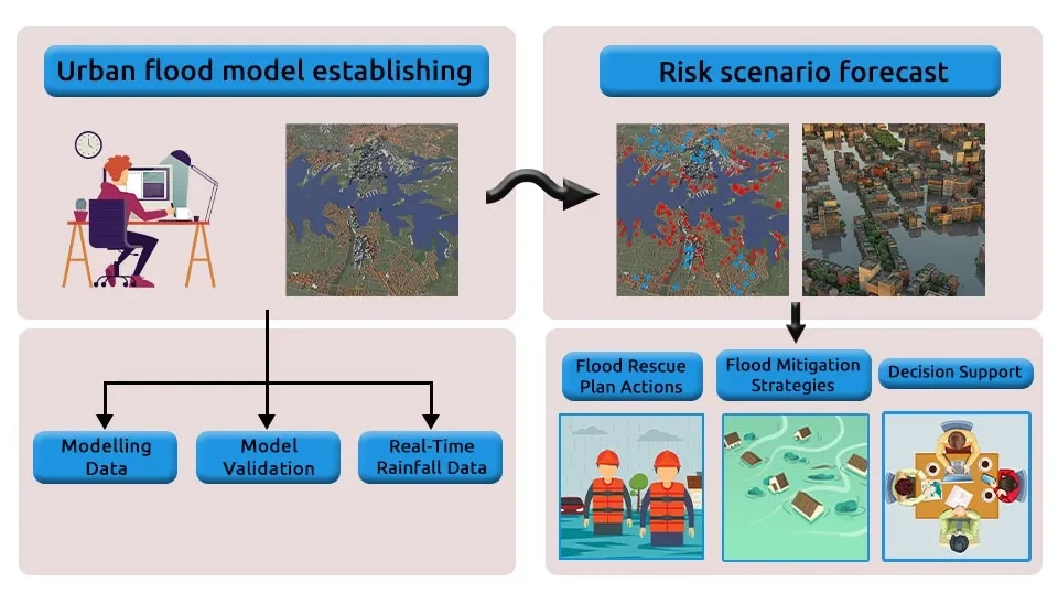
Fig. 4. Applications of urban flood models for urban flood management.
2. Five Widely Used Models for Urban Flood Simulation
Due to the importance of urban flood modeling, various models have been developed for the simulation of urban floods and the response of urban structures to hydrological processes. Despite the ability of these models in runoff generation and urban inundation simulation, they also face challenges and limitations, such as weakness in understanding and data related to the interaction between rainfall and runoff. On the other hand, unlike rural or river areas, urban flood modeling is complex and difficult due to urban heterogeneity, complex and irregular topography caused by buildings, urban infrastructure, and drainage networks. The evolution of urban flood models and improving their performance requires providing topographic and hydrological data with higher temporal and spatial resolution and predicting urban rainfall to finally ensure the compatibility and flexibility of urban flood systems (Song et al., 2014).
The three basic and effective components of urban flooding are rainfall, surface runoff, and urban drainage networks, which are included in urban flood models. In recent years, although the quality of input data and computing capacity have improved, the dynamics and nonlinear interactions between hydrological, hydromorphological, hydraulic, and hydrodynamic processes have increased the complexity of urban flood models. In addition, the improvement of flood models’ performance should be compatible with their accuracy and efficiency. This is because, with the increase in accuracy, the cost of calculation increases and the efficiency decreases, and vice versa. In the following, urban flood models are examined in detail (Guo et al., 2021).
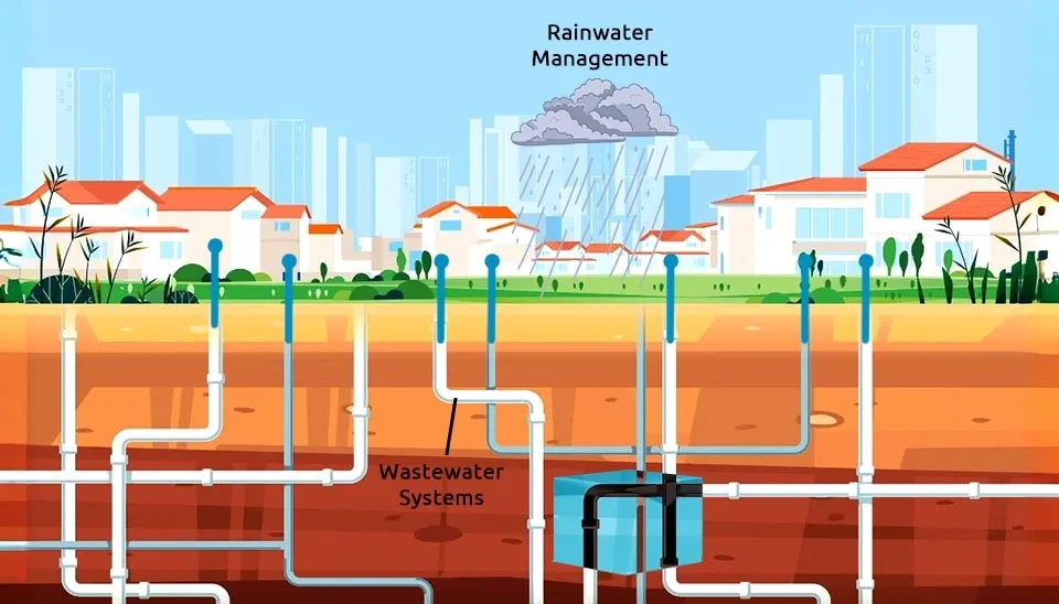
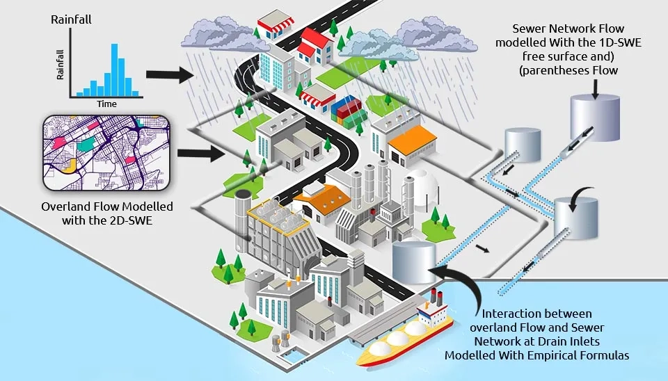
2.1. Drainage Network Modeling of Urban Floods
The urban drainage network drains surface runoff in built-up urban areas. Floods occur in urban areas when the drainage network is not able to carry and transfer urban surface runoff, and as a result, the overload of urban surface runoff (the difference between urban surface runoff and the capacity of the drainage network) spreads in the form of flooding in the urban areas. Drainage network models simulate urban flood, urban storm-water runoff, and drainage network flow and present the flow hydrograph at the outlet of the urban basin or catchment basins. Considering that these models simulate the urban drainage network, they need accurate information about the network of pipes and runoff transfer channels. The governing equations in urban drainage network modeling are Saint-Venant's equations, which are obtained from the laws of conservation of mass and momentum in an element of a channel or pipe. In the channel or the pipe, one-dimensional flow is considered. The flow in the pipe can be open-channel flow or pressurized flow, depending on the flow rate of the pipeline. The difference between open channel flow and pressurized flow is in the assumption of hydrostatic pressure, so if the flow is open, the pressure will be equal to the hydrostatic pressure due to the free surface. Open-channel flow and pressurized flow relationships are used to model the open-channel and pressurized drainage networks in urban drainage network models, respectively (Lee and An, 2019; Neelz and Pender, 2013).
Fig. 5. Illustration of an urban drainage network
2.2. Hydrogeomorphic Floodplain Models for Urban Areas
Hydrogeomorphic floodplain models are based on the concept of fractal river basins and are used in flood mapping, floodplain modeling, and flood risk assessment. In the hydrogeomorphic-based approach for flood simulation, increasing the accuracy of hydrological data and expanding high-precision digital terrain models have led to the production of valuable information about floodplain morphology, which is the result of hydrological processes and human factors. Due to the low need for time series data and high computational speed, hydrogeomorphic models can be used for hydrogeomorphic floodplain modeling on large spatial scales and even global watersheds. The results of previous studies show that hydrogeomorphic floodplain models are capable of creating flood maps despite changes in scaling parameters. The results also show that the hydrogeomorphic floodplain model can reasonably simulate floods in urban basins and make large-scale maps of floodplains in areas where infrastructure and people have an impact. Despite the advantages of hydrogeomorphic models for urban inundation simulation, these models cannot simulate flood dynamics consisting of water depth, velocity, etc. (Nardi et al., 2018).
Fig. 6. Application of hydrogeomorphic floodplain models for simulation of urban floods (Nardi et al., 2018)
2.3. Shallow-water Models for Urban Areas
Models based on shallow-water equations are used in the simulation of river floods, coastal floods, and urban floods. They can provide detailed information about the characteristics of urban floods, such as flood depth and velocity. On the other hand, improving the input of shallow-water models, including data with high spatial resolution, digital elevation, and surface models, can improve the accuracy of urban flood simulation with shallow-water models (Xia et al., 2017; Gómez et al., 2011). Since the urban flood cannot be considered one-dimensional and spreads in two-dimensional and three-dimensional paths in different directions, its modeling requires heavy and complex calculations. However, according to the flow conditions, simplifying assumptions can be made. The governing equation in shallow-water models is the Navier-Stokes equation, which describes the motion of an incompressible fluid. Since urban runoff and flood are considered shallow flows, the Navier-Stokes equation can be simplified in the vertical direction, and urban flood can be calculated and modeled by considering the shallow water flow under the influence of gravity and free surface (Guo et al., 2021). Generally, models based on shallow-water equations are divided into two categories: simplified shallow-water and full shallow-water models, which are discussed below.
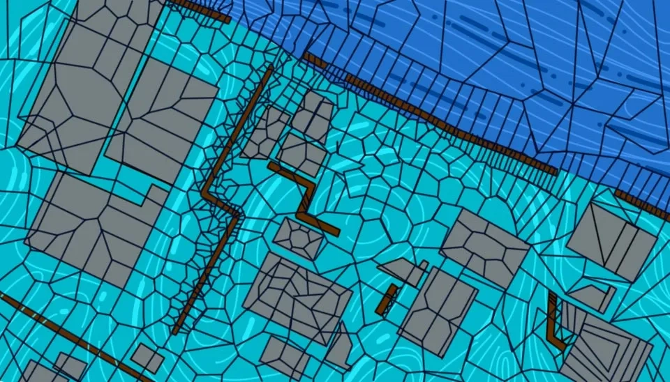
Fig. 7. Urban inundation simulation with two-dimensional shallow-water models
2.3.1. Simplified Shallow-water Models
Considering the cost and computational requirements of shallow-water models for urban flood simulation, simplified models based on the shallow-water equation have been presented, in which inertial-local acceleration and advection-convective acceleration are ignored and two-dimensional diffusion is considered. Uncertainty of various inputs, lack of sufficient data, and complex and irregular topography cause urban flood modeling, especially on a large scale with simplified shallow water models, to be challenging. However, with the help of numerical methods, these models can have high accuracy and efficiency in urban flood simulation (Willis et al., 2019; Leandro et al., 2016).
2.3.2 Full-Shallow-water Models
Assumptions and simplification of simplified shallow-water models, despite the reduction in computational cost, lead to the elimination of some hydraulic and hydrological processes. Full models based on the shallow-water equation, despite the high computational cost, have a high ability to simulate complex flow regimes and provide higher accuracy in large-scale urban flood simulation. The development of computational algorithms and techniques to increase the speed of solving has helped the spread of full shallow-water models to be widely used in the simulation of urban flood dynamics. However, there are challenges regarding improving numerical stability, accuracy, and reliability in flood simulation on slopes and in non-linear friction conditions (Xia et al., 2017).
2.4. Data-Driven Approaches for Urban Flood Modeling
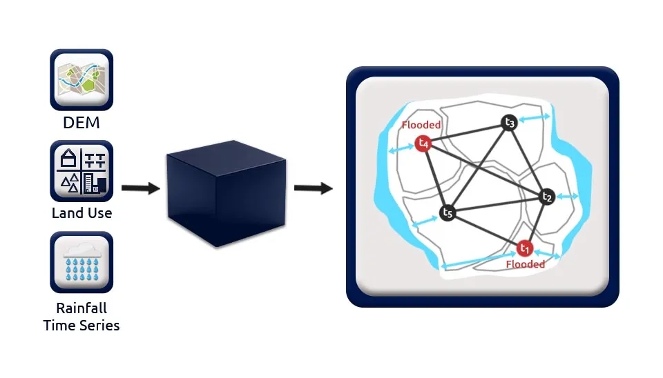
The high computational requirement of models based on physical processes in the simulation of urban flooding, especially in large urban areas with high spatial resolution, has challenged the efficient analysis of urban flooding. The solution to face this challenge and improve computing time is to use data-driven methods (Guo et al., 2020). With the improvement of the quality of hydrological data and their availability, data-driven models such as deep learning models such as artificial neural networks and machine learning models have been expanded in recent years. Acceptable performance of data-driven models requires abundant and high-quality field data to train data-driven models in black box format. It is worth mentioning that data-driven models can integrate physics-based and human-sensed features in order to use the physics governing the process in urban flood simulation. Data-driven models can also provide spatial and temporal analyses through convolution networks, which have a reasonable computational cost compared to physical models. Data-driven models include many human and physical factors in the model and identify factors that have a significant impact on urban flood simulation. The results of data-driven models include static and dynamic characteristics, hydrodynamic changes, and heterogeneous dynamic characteristics (Farahmand et al., 2023).
Fig. 8. Data-driven approach for urban flood simulation
2.5. Cellular Automata Urban Modeling
Cellular automata is a framework and model for modeling the dynamics of physical systems. In cellular automata, there is a regular network of cells that is regulated by local rules, and each cell includes limited features. Over time, the state of each cell is determined based on the previous state of the same cell and its neighboring cells, and the system evolves. Cellular automata have attracted the attention of researchers and are used in various sciences, such as fluid dynamics, computational theory, mathematics, physics, and microstructure modeling. One of the applications of cellular automata in water sciences is flood simulation and representation (Dottori and Todini, 2011; D’Ambrosio et al., 2003). The cellular automata approach in urban flood simulation, instead of solving shallow water relations, uses discrete simulation for each cell. Compared to one-dimensional hydraulic models, it can achieve reliable output with less cost and computational requirements. Also, the cellular automata approach uses simple rules instead of complex equations, which can be effective for simulating floods and analyzing them quickly on a large scale. Cellular automata models have a high ability to simulate water depth and speed in a short time and reasonable computing memory compared to other models. However, limited studies have investigated their performance in simulating urban floods, and more studies are needed to reproduce one-dimensional and two-dimensional flow dynamics(Guidolin et al., 2016).
Fig. 9. An example of cellar automata model results for urban flood simulation (Stamellou et al., 2021)
3. Physical Approaches for Urban Flood Modeling
Urban flood models are divided into two categories (hydrological and hydrodynamic) based on the physical solution method and algorithm, which will be briefly explained below. There are other approaches to urban flood simulation, such as data-driven or simplified, but due to the fact that these models do not consider the physics and dynamics of urban floods, they have been ignored in this section.
3.1. Hydrological Methods and Models
Hydrological models are based on basin hydrology, where cities are considered as sub-basins or small basins. In hydrological models, precipitation is the key input,l in which water is led to the exit of the city through the drainage system. Soil and Water Assessment Tool (SWAT), the Hydrologic Engineering Center's Hydrologic Modeling System (HEC-HMS), and MIKE System Hydrological European (MIKE SHE) models are among the most widely used urban flood models. Hydrological models consider only a part of the hydrological process, and the definition of precise boundary conditions such as river surface runoff is important in urban flood models based on hydrological processes. The development of Geographic Information System (GIS) technology has helped to analyze the spatial distribution of hydrological models (Qi et al., 2021).
Fig. 10. Urban hydrology as a part of the whole hydrology
3.2. Hydrodynamic Methods and Models
Hydrodynamic models have a high capability of simulating the hydraulics of urban floods, taking into account the hydraulics of the urban drainage system, the system of canals, streets, and other microtopographies. Therefore, the performance of hydrodynamic models requires the topographic features of the urban basin, and they are widely used in the simulation of urban floods. Most of the hydrodynamic models in urban flood simulation are based on shallow water equations, in which numerical methods (finite volume and finite element methods) are used to simulate surface flow (Su et al., 2019). The importance of numerical methods with high resolution in simulating urban floods is significant in areas with complex topography such as streets, buildings, and canals, which leads to an increase in computational cost. The limitation caused by the high computational cost of hydrodynamic models in simulating urban floods has led to the emergence of assumptions and simplifications in them, such as the approximation of the diffusion wave and ignoring the acceleration effect. Another approach to reducing the computational cost of hydrodynamic models is to limit them to one or two dimensions. One-dimensional models need less information, and by ignoring spatial changes, they have a low computational cost; however, 2-dimensional models provide more accurate results (Morales-Hernandez et al., 2013).
4. Conclusion
The continuous expansion of urbanization and climate change has led to the prevalence of urban flooding, which requires urban flood modeling and flood risk assessment to reduce the risks associated with urban flooding and help increase urban resilience. Flood-prone areas have increased in recent years, and today more than 90,000 square kilometers of the world's urban areas are at risk of flooding, which are mainly located in coastal urban areas in the United States and China. Urban flood modeling requires a detailed assessment of flood-governing processes and flood assessment and forecasting. In recent decades, several models have been developed for urban flood simulation, which face challenges such as urban heterogeneity, complex topography, and drainage networks due to the complexity of urban environments. Improving the performance of urban flood models requires high-resolution topographic and hydrological data as well as accurate prediction of urban rainfall. However, it is necessary to establish a balance and trade-off between the accuracy and efficiency of urban flood models in order to achieve accurate results with a reasonable computational cost. In this article, five of the most widely used and main urban flood models (drainage network models, hydrogeomorphic floodplain models, shallow-water models, data-driven approaches, and cellular automata urban models) were reviewed. Urban flood models are included in hydrological and hydrodynamic algorithms (methods) based on physical processes. Most of the models reviewed in this article (all models except data-driven models) are based on physical relationships and processes, which have advantages and disadvantages depending on their application. In general, the main challenge in most urban flood models is computational cost, quality input data, and capability for large-scale simulation. However, it is expected that in the future, the limitations and challenges associated with urban flood models will be resolved, so that by providing flood risk maps, urban resilience will be improved and urban flood risks will be minimized.

-6799eee693c66f7da78a9c3f)


Comments
No comments yet
Be the first to comment
Share your thoughts and start the conversation.