
It is estimated that the global hydrological modeling market is expected to grow from $12.13 Billion in 2015 to $22.17 Billion by 2026, at a CAGR of 5.7%.
Are you interested in learning how USGS hydrological modeling software is transforming so we can better manage water resources? It is estimated that the global hydrological modeling market is expected to grow from $12.13 Billion in 2015 to $22.17 Billion by 2026, at a CAGR of 5.7% (MarketsandMarkets, 2020). This growth rate indicates a significant increase in demand for hydrological modeling software, highlighting its importance in water resources management.
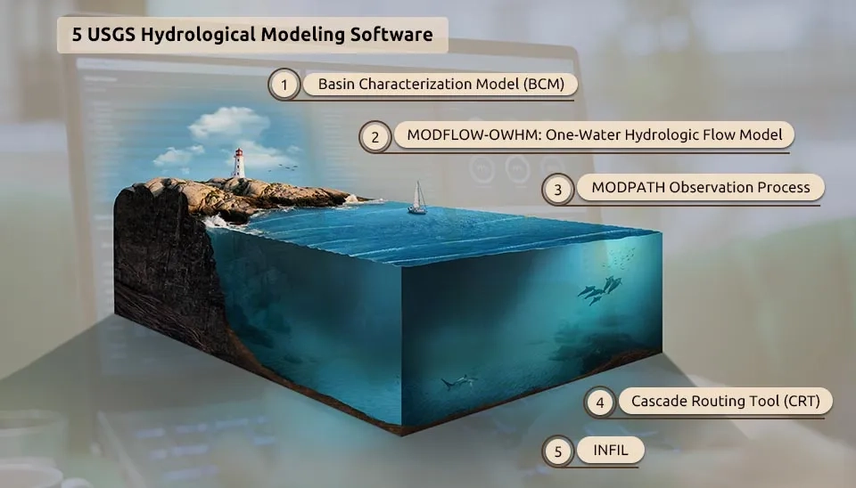
Table. 1. 5 USGS Hydrological Modeling Software
Model | Application |
Basin Characterization Model (BCM) | Water resources planning and management |
MODFLOW-OWHM | Assessment of impacts of management scenarios on groundwater resources |
MODPATH Observation Process | Understanding the potential impacts of contamination on water resources |
Cascade Routing Tool | Assessment of impacts of management scenarios (e.g., dam operations) on downstream water resources |
INFIL3.0
Understanding how much water is entering the groundwater system in a given area |
Download Full Table of5 USGS Hydrological Modeling Software
Hydrological modeling is critical for comprehending and managing water resources. It involves simulating the movement of water through various components of the hydrological cycle, such as precipitation, evaporation, runoff, and groundwater flow. Hydrological modeling software finds extensive application in the field of water resources management, flood forecasting, and environmental impact assessments. It enables hydrologists, engineers, and researchers to simulate and predict the behavior of water systems under different scenarios, facilitating the decision-making processes (Horton et al., 2021; Baydaroğlu et al., 2022).
The output format of hydrologic modeling software typically includes visual representations, such as maps, graphs, and tables, which provide insights into water quantities, flow patterns, and other hydrological parameters (Sahu and Prasad, 2018; Fatichi et al., 2017). This article provides a comprehensive overview of hydrological modeling software, primarily USGS products, along with their key features and some notable examples.
The U.S. Geological Survey (USGS) has been at the forefront of hydrological modeling software development since the 1960s. Their models are widely used to predict the responses of hydrological systems to changing stresses and assess the movement of solutes and contaminants in water (USGS, 2018). Many approaches to hydrologic modeling have been developed. In the following, five key software programs for hydrologic modeling are introduced.
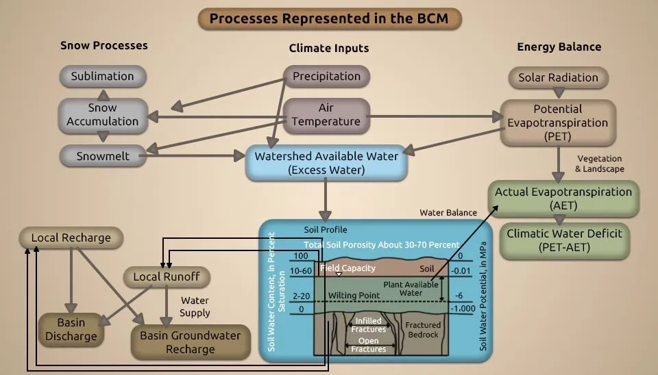
The Basin Characterization Model (BCM) is a regional water balance model that has been applied to numerous watersheds at a fine scale of 270 m grid cells to assess the impacts of climate change on both water availability and ecosystems. The BCM calculates water balance components, including runoff, recharge, evapotranspiration, soil moisture, and stream flow, based on climate, topography, soils and underlying geology, and the solar-driven energy balance. This map‐based, mechanistic model focuses on the interactions between climate (rainfall and temperature) and landscape attributes (topography, soils, and underlying geology) to calculate the water balance of a given watershed (USGS, 2018).
The BCM enables the generation of scenarios at different time steps, allowing for a detailed analysis of water resources. The results of this model testing permit a better interpretation of where hydrologic simulations perform better or worse due to the influences of landscape variables. The BCM can be used to identify locations and climatic conditions that generate excess water by quantifying the amount of water available either as runoff or as in-place recharge monthly (Flint et al. 2015; Thorne et al. 2012; Micheli et al., 2012).
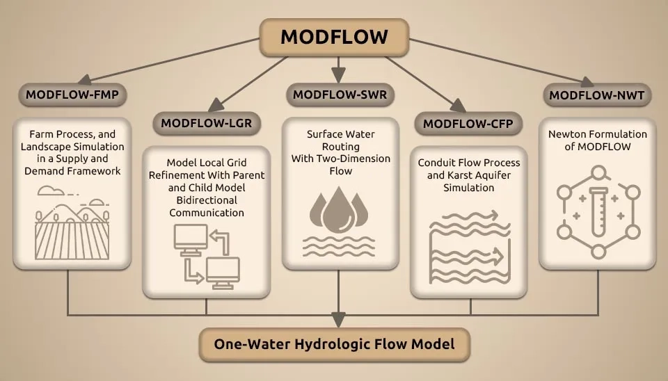
MODFLOW-OWHM is an Integrated Hydrologic Model (IHW) that simulates and analyzes water movement within a physically based supply-and-demand framework. The MODFLOW One-Water Hydrologic Flow Model combines multiple MODFLOW variants in one cohesive simulation software. It is the most complete version of the MODFLOW family of hydrologic simulators that is designed to address various conjunctive-use issues, water management, water-food security, and climate-crop-water scenarios, facilitating the management of human and natural water movement. Conjunctive use is the combined use of groundwater and surface water (Hanson et al. 2014).
MF-OWHM includes new features since MODFLOW-2005, such as the Surface-water Routing Process (SWR), Seawater Intrusion (SWI), and Riparian Evapotranspiration (RIP-ET), and new solvers such as Newton-Raphson (NWT) and nonlinear preconditioned conjugate gradient (PCGN). MF-OWHM represents a complete operational hydrologic model that fully links the movement and use of groundwater, surface water, and imported water for consumption by irrigated agriculture, as well as water used in urban areas and by natural vegetation. From large- to small-scale settings, MF-OWHM has unique capabilities to simulate and analyze historical, present, and future conjunctive-use conditions (Boyce et al. 2020).
1.3. MODPATH Observation Process
The MODPATH Observation Process (MODPATH-OBS) is a program developed to calculate simulated equivalents to transport observations derived from particle tracking. It helps analyze and interpret hydrological settings and can be used for transient and steady-state flow simulations. The simulated equivalents supported by MODPATH-OBS are (1) distance from a source location at a defined time or proximity to an observed location; (2) time of travel from an initial location to defined locations, areas, or volumes of the simulated system; (3) concentrations used to simulate groundwater age; and (4) percentages of water derived from contributing source areas. This program can also account for simple decay or production, but it cannot account for diffusion (Hanson et al. 2013).
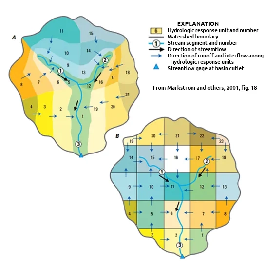
The U.S. Geological Survey Cascade Routing Tool (CRT) is a powerful computer program used to compute flow paths among Hydrologic Response Units (HRUs) and Groundwater Reservoirs (GWRs), defined for watershed simulation that includes the Precipitation-Runoff Modeling System (PRMS). The CRT provides a valuable output that defines cascading surface and shallow subsurface flow paths for grid-based model domains. CRT also includes an option to condition the grid-scale Digital Elevation Model (DEM) to fill unintended swales and to provide continuous down-sloping HRUs that follow streams.
CRT requires a land-surface elevation for each HRU of the model grid. Additionally, a list of the HRUs is required, which must include streams, swales, lakes, and other cascade termination features, along with indices that uniquely define each of these features. Cascades are predefined flow paths that can be used for routing surface and shallow subsurface lateral flow in hydrologic models. Using a cascade module can allow for a more realistic representation of the effects of topography and topology on watershed drainage relative to a simulation without cascades. CRT is used externally to the watershed model so that the computed cascades can be evaluated before a simulation to make sure that water is routed appropriately (Henson et al. 2013).
INFIL is a grid-based, distributed-parameter, deterministic water-balance model that calculates the temporal and spatial distribution of daily net infiltration of water across the lower boundary of the root zone. The primary climatic inputs to the model are daily precipitation and maximum and minimum air temperature. It considers various components of the water balance, such as precipitation; snowfall accumulation, sublimation, and snowmelt; evapotranspiration; drainage and water-content redistribution; surface-water runoff; etc.
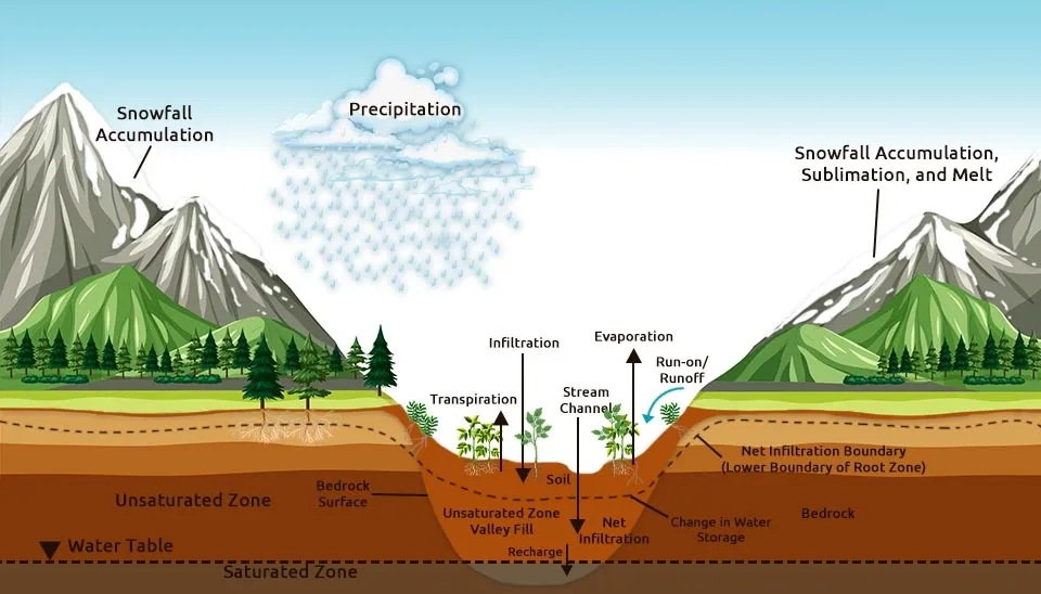
INFIL gives an overview of the water movement across the root zone and can be valuable for understanding water-table aquifers. The INFIL model is based on a conceptual model of the physical processes that control net infiltration across the lower boundary of the root zone. The conceptual model was developed to represent the major components of the water balance for arid to semiarid environments but may also be applicable to more humid regions (FILL, 2008).
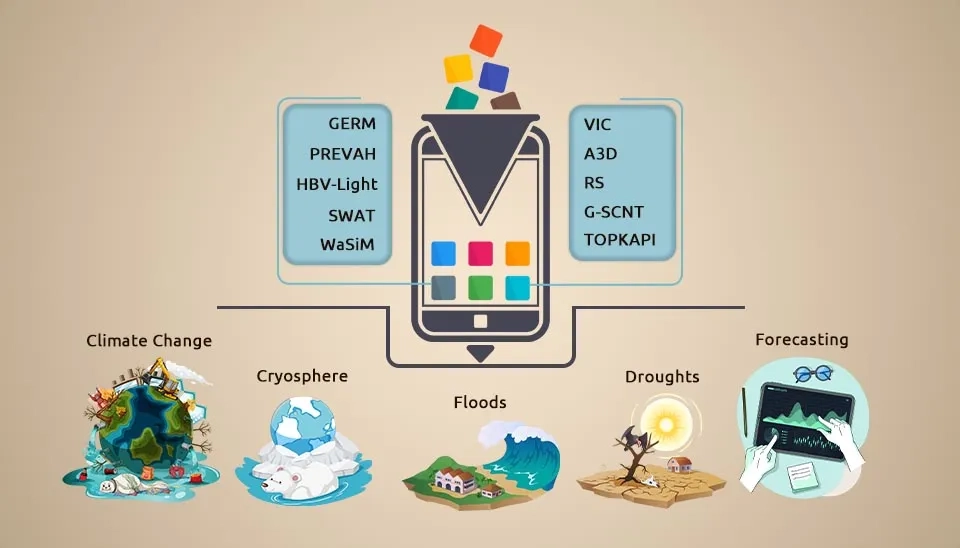
Apart from the USGS-developed models, several other notable hydrological modeling software tools are available in the market. Other hydrologic models that help with water resources comprehension, forecasting, and management include HEC-HMS (flash flood risk assessment) (Mandal and Chakrabarty, 2016); SCS-CN (Soil Conservation Service Curve Number) (Sahu et al., 2023); SWAT (Soil and Water Assessment Tool) (Arnold et al., 2012); MODSIM (a Decision Support System for Integrated River Basin Management) (Berhe et al., 2013); GERM (Glacier Evolution Runoff Mode); HYPE (Hydrological Predictions for the Environment); PREVAH (Precipitation–Runoff–Evapotranspiration HRU Model); and VIC (Variable Infiltration Capacity model) (Horton et al., 2021; Wi et al., 2017).
Hydrological modeling software is an essential tool for understanding and managing water resources. With recent advances, these software tools have revolutionized our ability to predict and manage water-related sustainability issues. The USGS has been a significant contributor to the development of hydrological models, including the Basin Characterization Model (BCM) and MODFLOW-OWHM. Hydrological modeling software finds extensive application in various fields related to water resources management, flood forecasting, and environmental impact assessments. While these tools offer numerous benefits, it is important to consider their limitations and validate and calibrate models using observed data. As technology advances, hydrological modeling software is expected to evolve further, incorporating artificial intelligence, machine learning, and socio-economic factors for better accuracy and user-friendly interfaces.
Quick answers to common questions.
Keep reading


Comments
No comments yet
Be the first to comment
Share your thoughts and start the conversation.