LiDAR Technology: 10 Applications in Water Science
LiDAR (light detection and ranging) has been significantly expanded and developed since the invention of the laser in 1960, and today it is widely used in terrestrial, atmospheric, hydrological, altimetry, and oceanographic studies.
Revolution in water studies and science with temporal and spatial hyper-resolution data in the shortest time: this is the shortest definition that can be given of LiDAR applications in water resources. LiDAR (light detection and ranging) has been significantly expanded and developed since the invention of the laser in 1960, and today it is widely used in terrestrial, atmospheric, hydrological, altimetry, and oceanographic studies (Wang et al., 2020). On the other hand, it is expected that the reliance on LiDAR will increase in the future for the management of natural resources such as ecology, forestry, wildlife, geomorphology, and geology to make improved and sustainable decisions and strategies, leading to the optimal management of natural resources (Hudak et al., 2009).
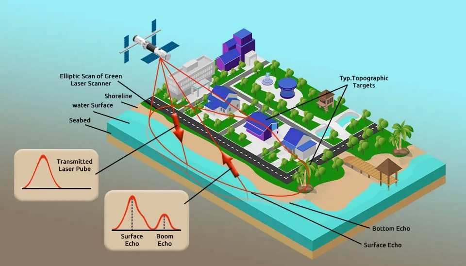
Fig. 1. An illustration of airborne LiDAR technology showing a green laser scanner transmitting pulses from a satellite to a coastal area for bathymetric mapping.
Terrestrial LiDAR and airborne LiDAR are two types of LiDAR Remote Sensing that can be used in different sciences, including water science, depending on the application. The data obtained from terrestrial and airborne LiDAR are superior compared to conventional data collection methods, such as high data recording speed, high accuracy, no restrictions in inaccessible areas, high details of recorded data, and high temporal and spatial resolution (Dassot et al., 2011; Liu et al., 2008). One of the valuable natural resources that requires a precise approach to measure its characteristics is water resources. In this article, we discuss LiDAR technology in water studies in detail.
Table.1. Advantages and Disadvantages of LiDAR in Water Science (Brief Table)
Application of LiDAR in Water Science
Advantages
Disadvantages
LiDAR in Coastal Research and Management
Increased Pulse Density
Large Area Coverage
Limitations in the Early 2000s
High Computational Time and Cost
LiDAR in Flood Modelling and Management (Flood Hazard and Risk Mapping)
Improved Flood Modeling
Large-Scale Flood Modeling
High Computational Time
Weakness in Complex Urban Features
LiDAR in Urban Inundation Modeling
Enhanced Simulation Accuracy of Inundation
Distinguishing Buildings from Vegetation
Weakness in Complex Urban Features
Ethical and Legal Issues in Urban Areas
LiDAR for High-Resolution DEM
High-Resolution and Accurate Topographic Information
In recent years, LiDAR technology has made progress in many sciences, including environmental engineering, in a deeper understanding of physical governing phenomena. Studying atmospheric processes, improving weather forecasting, measuring oceans, measuring and differentiating vegetation, analyzing biosphere and cryosphere, and hydrological processes are among LiDAR applications in water resources (Wang and Menenti, 2021). The advantages and superiority of LiDAR over conventional methods have caused LiDAR technology in water science to be widely considered by researchers. In the following, we will discuss the applications of LiDAR in water sciences (hydrology, hydrodynamics, hydraulics, etc.).
1.1. LiDAR in Coastal Research and Management
LiDAR technology has gained attention in coastal research since the early 2000s. In the early 2000s, LiDAR technology faced limitations and weaknesses in coastal studies, such as being limited to near-infrared, few pulses (several thousand per second), recording the first and last time of radiation and reflection, and not penetrating water. Over time, LiDAR technology has been able to record more than a hundred thousand pulses per second and assess large areas (hundreds of square kilometers) of coastal areas within a day. One of the applications of LiDAR, especially airborne LiDAR, is in coastal research and management. Integration of the LiDAR system with passive optical imaging can provide valuable information on hydrological, morphological, biological, and geological processes related to coastal areas and the geomorphic structure of shallow sea environments. The data obtained from LiDAR, especially in coastal areas prone to floods, storms, and tsunamis, can lead to the prevention of natural disasters. Studies of LiDAR in coastal areas include topographic mapping of beaches, assessment of vegetation canopies, assessment of coral reefs, assessment of landslides and subsidence, and study of geomorphic changes along the coast caused by storms and sedimentation. Therefore, LiDAR technology in water studies related to coastal areas can help in better management of these areas (Brock and Purkis,2009). The shoreline is one of the coastal areas that has been subject to erosion in recent years due to human factors and interventions such as excessive construction in coastal areas and climate change. Airborne LiDAR can analyze shoreline changes by assessing bathymetry in coastal areas (Tak et al., 2020; Kim et al., 2017).
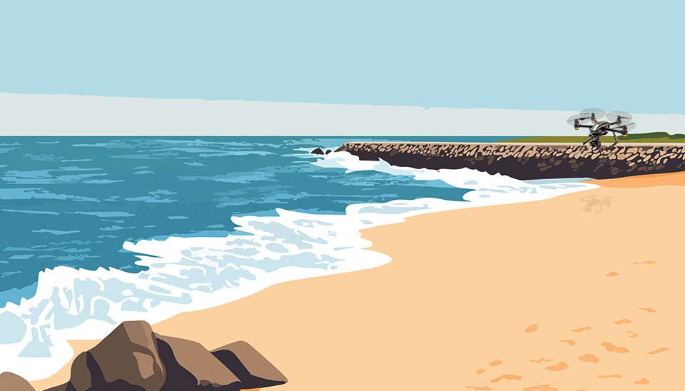
Fig. 2. A drone with a terrestrial LiDAR system ready for deployment on a beach to collect high-resolution data for coastal monitoring.
1.2. LiDAR in Flood Modelling and Management (Flood Hazard and Risk Mapping)
Considering the irreparable damages caused by floods to the infrastructure, environment, and human life, many studies have been done to monitor and map the frequency and severity of floods all over the world. Flood modeling and flood risk mapping can significantly reduce the risks caused by it, which has been achieved to some extent with the development of advanced flood mapping and monitoring technologies. Land observation and its topographic condition can help in more accurate flood modeling, flood mapping, and monitoring. LiDAR technology has been able to improve flood modeling by providing high-resolution DEM. High-resolution LiDAR DEMs (about one inch) can also provide the possibility of large-scale (regional to continental) flood modeling. In addition, LiDAR can penetrate dense vegetation and provide low-cost and fast data, helping the flood modeling process and improving its accuracy. However, LiDAR applications in water resources face challenges. Challenges associated with LiDAR in flood assessment and management include high computational time, weakness in complex urban features, large data file size, and inefficiency in channel bathymetry. However, the integration of multi-platform LiDAR data consisting of airborne and terrestrial LiDAR with other data can solve the mentioned challenges and contribute to the accuracy of flood models (Kabite, 201; Choné et al., 2021).
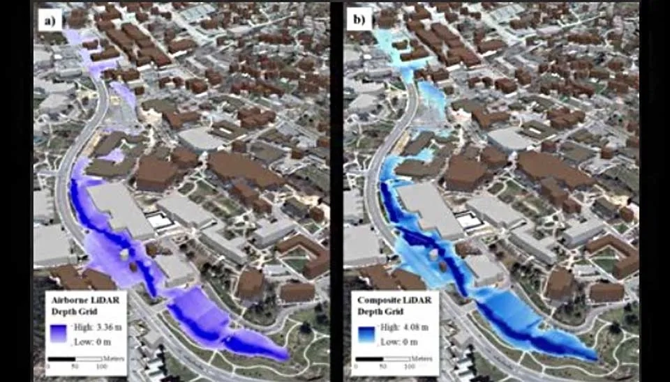
Fig. 3. A comparison of urban inundation models showing a flood depth grid created with (a) airborne LiDAR data and (b) composite LiDAR data
1.3. LiDAR in Urban Inundation Modeling
An inundation is a phenomenon that occurs due to a rapid flow or a sudden increase in the water level. This phenomenon covers a wide range of lands, such as agricultural lands, flooded plains, rural areas, and densely populated urban areas, which causes serious economic and human losses, especially in urban areas. Optimal management and risk assessment of urban inundation requires modeling of the dynamic process that governs it. LiDAR technology can facilitate the modeling process and improve the simulation accuracy of inundation. LiDAR technology can distinguish buildings from vegetation, extract accurate spatial information about buildings (their shape and position), and provide high-resolution DEM to enhance Urban Inundation Modeling.. LiDAR has an important application in densely populated areas that have complex topographic features, and by replacing it with labor for data preparation, it can facilitate the production of an accurate inundation flow network (Tsubaki and Fujita, 2010).
Both airborne and terrestrial LiDAR can be used in urban inundation studies, 2D hydraulic modeling, and inundation risk analysis. Compared to terrestrial LiDAR, airborne LiDAR can produce DEM of a large area in a short time. A multi-centimeter resolution terrestrial LiDAR system extracts hydraulically relevant small-scale topography such as street edges in high-resolution DEMs to improve urban inundation modeling related to surface water, map, and risk assessment, and planning for sustainable urban drainage systems with more details (Sampson et al., 2012; Ozdemir et al., 2013).
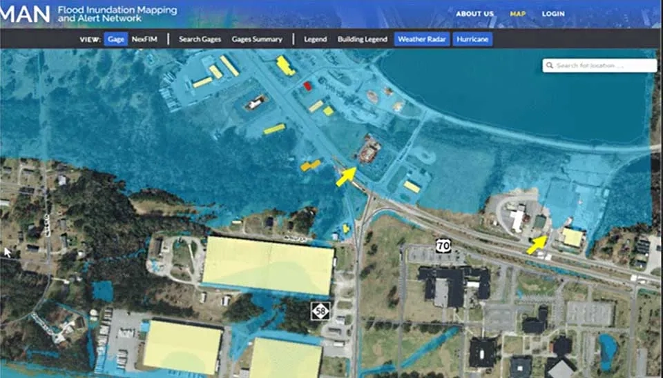
Fig. 4. An aerial view of a coastal town overlaid with a flood map, showing areas of potential inundation derived from high-accuracy LiDAR data.
1.4. LiDAR for High-Resolution DEM
High-resolution and accurate topographic information is important for improving hydrological modeling and increasing the accuracy of flood forecasting, especially at a small spatial scale. Since conventional and in situ methods are weak in producing accurate Digital Elevation Model (DEM), LiDAR technology in water studies has made it possible to produce DEMs with high density and resolution and be used as an input for flood assessment models. Also, LiDAR technology can provide sufficient topographic information in inaccessible and complex topographical areas through the integration of terrestrial and airborne LiDAR. Therefore, it is expected that LiDAR will widely replace conventional methods in the future. Despite the application of LiDAR in producing high-resolution DEM maps, there are still challenges in DEM in the filtering process, high storage volume, and computational cost (Muhadi et al., 2021). Accordingly, different filtering algorithms are provided to improve the filtering results. Paying attention to modeling methods and interpolation algorithms can also help to solve LiDAR challenges in obtaining DEM. Further, the resolution of DEM should also match the density of LiDAR data. To solve the challenge related to storage limitation, it is necessary to remove unimportant or less important data and keep critical elements such as broken lines to reduce the number of data points and storage volume while maintaining DEM accuracy (Liu et al., 2008).
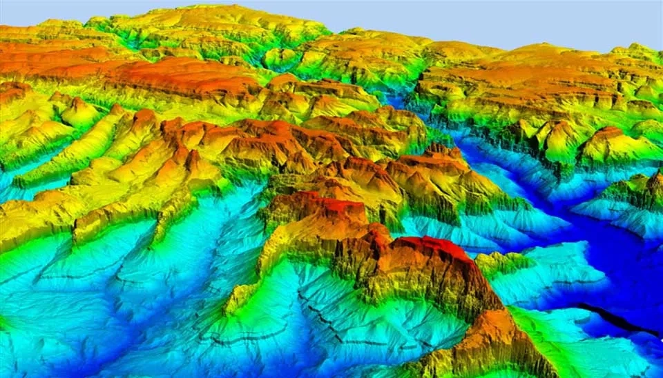
Fig. 5. A visualization of terrain and surface roughness data derived from LiDAR, with different colors representing varying elevations in a mountainous region.
1.5. LiDAR in Surface Roughness Maps
Surface roughness is one of the significant inputs of hydraulic, hydrological, and hydrodynamic models; it affects the modeling output, such as reliable flood forecasting, by affecting the boundary conditions and flow regime. The values related to the surface roughness can be extracted from the mining formula, the Land Use and Land Cover (LULC) classification, or different sources, such as orthophotos and LiDAR data. Previous studies show that orthophoto and CORINE Land Cover (CLC) data are not suitable for small-scale areas due to their low resolution. Among the sources of surface roughness extraction, LiDAR data can be used in hydrodynamic models due to its high resolution and coverage of spatial details to increase the simulation accuracy. Since vegetation and objects on the surface of the earth affect the flow, it is necessary to define their complete details as input to the model using LiDAR surface roughness data (Straatsma and Baptist, 2008; Dorn et al., 2014). However, in areas with high vegetation density, LiDAR is challenging due to signal blocking and lack of land in nearby areas, which requires integration with other methods such as GPS and the use of terrestrial LiDAR (Zhang et al., 2021).
Fig. 6. LiDAR in bathymetry: A visualization of a laser pulse penetrating a water column, with one part reflecting from the surface and the other from the bottom.
1.6. LiDAR in Bathymetry and Submerged Aquatic Vegetation
One of the applications of LiDAR in water science is the extraction of bathymetric data, including in coastal areas, which is used for coastal management and research programs. The high accuracy of LiDAR in extracting bathymetry (about 10 to 15 cm) in spatial resolutions greater than one height measurement per square meter has made LiDAR play a key role in various water resources research, such as flood risk assessment, beach nutrition analysis, analyzing shallow and benthic environments, and mapping regional changes caused by storms or long-term sedimentary processes. The ruling mechanism in LiDAR bathymetry is that the sensor installed on a platform (a moving platform like an airplane or a stationary one like a bridge) sends a pulse to the air-water interface. Part of the pulse is reflected from the air-water interface and returns to the sensor, but the other part of the pulse penetrates the water column and is reflected from the bottom of the water. To increase the penetration of the pulse in water, LiDAR uses a laser with a wavelength of 530 nm (blue-green range) to reduce the bathymetry error. As a result, LiDAR can estimate the water depth by measuring the time between the surface return and the bottom return. LiDAR can penetrate water up to three times the depth of Secchi and extract bathymetric data, but in general, LiDAR's performance in bathymetric measurement depends on transparency and turbidity. As the turbidity and suspended sediments of water increase, the bathymetry accuracy of LiDAR decreases, in which case other methods such as acoustic echo-sounding methods can be used for bathymetry. In addition, LiDAR is used to map submerged aquatic vegetation and coral reefs in lagoons and beaches through high-resolution imagery. Since coral reefs mainly grow in clear waters, LiDAR can classify them, but the growth of submerged aquatic vegetation in waters with high turbidity causes challenges for mapping by LiDAR (Klemas, 2011).
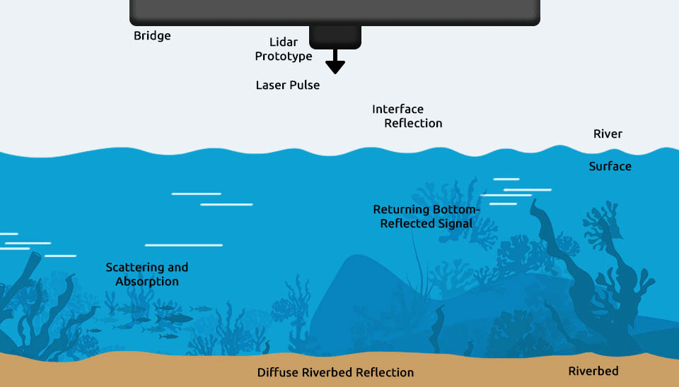
Fig. 7. A visualization of how LiDAR technology works for river monitoring, showing signal scattering, absorption, and reflection from the riverbed.
1.7. LiDAR in Analysis of Water Levels
One of the applications of LiDAR in water science is to measure the water level of rivers. It is important to measure the water level of the river to estimate its flow and evaluate the possibility of flooding. Compared to field methods, especially for inaccessible areas, LiDAR-based methods are more accurate for measuring small fluctuations in river water levels. They are superior to in situ methods due to their low cost, high spatial and temporal resolution, and higher efficiency. For example, using LiDAR in the infrared range with a wavelength of about 905 nm, it is possible to measure the river water level with an error of less than one percent. Although water reflects infrared radiation in a small way, LiDAR can measure the water level of the river with an accuracy of less than one centimeter per ten-meter measurement distance. Still, as the measured distance increases, LiDAR accuracy in estimating water level decreases. In general, LiDAR can be installed under the bridge, and by continuously measuring the water level of the river as an early warning system, it can inform about the possibility of flooding (Paul et al., 2020).
Among the LiDAR-based methods for water level measurement, near-infrared LiDAR has the potential to be accurate. Although water has little reflection for infrared radiation, studies have shown that near-infrared LiDAR in the range of 850 nm can be effective in different water patterns and turbidity conditions, so that even if the water turbidity is around 700 NTU (Nephelometric Turbidity Units), near-infrared LiDAR can measure the water level with an accuracy of about 5% (Jannata et al., 2021). In addition, the use of LiDAR for water level measurement is not limited to rivers; it can also be used in various studies, such as lake level measurement. The results of measuring the water level of water bodies using LiDAR can help to improve the accuracy of hydrological and groundwater studies such as hydraulic head simulation and estimation of groundwater levels (Shrestha et al., 2021).
1.8. LiDAR in Ocean Measurement
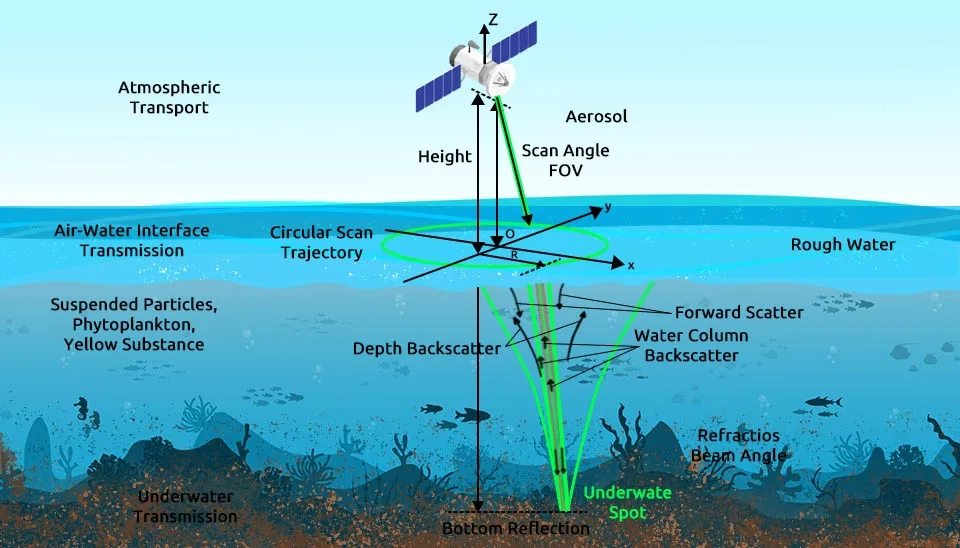
During the last decades, airborne LiDARs have been used to study the quantitative and qualitative characteristics of the ocean subsurface. For example, the results of Cloud-Aerosol Lidar with Orthogonal Polarization (CALIOP) LiDAR show its effectiveness in measuring the depth of plankton features. Also, the LiDAR system equipped with Raman scattering, Brillouin scattering, and fluorescence signals can measure the thermal structure of the oceans, salinity, and other chemical and qualitative variables of water (Lima et al., 2019; Lu et al., 2016).
One of the types of LiDAR is oceanic LiDAR, which is used for measuring water depth in coastal areas and extracting the optical properties of water bodies, including oceans. In oceanic LiDAR, underwater echo signal generation and inversion of optical parameters using water echo signals, along with analytical and statistical methods (radiation transfer equation and Monte Carlo model), are used to extract optical features of water. The development of oceanic LiDAR seeks to improve performance in more accurate detection of water resource parameters and increase efficiency so that, in the future, it can identify the way lasers are emitted underwater and related to water turbulence, inelastic Raman scattering, and other water quality parameters, such as sediments. Oceanic LiDAR is expected to deepen our understanding of oceans and underwater environments in the future (Zhou et al., 2021).
Fig. 8 LiDAR in Ocean Measurement: a visual representation of how a laser pulse interacts with the water column and its optical properties to measure the ocean subsurface.
1.9 LiDAR in Hydrology Analysis
LiDAR technology in water studies can improve the hydrological analysis of water resources. One of the applications of LiDAR in water science is to improve the performance of hydrological models. LiDAR and remote sensing-based methods can improve the input of hydrological models, such as watershed information and boundary conditions, and help in calibrating hydrological models and estimating their parameters (Duan et al., 2021). DEM data obtained from LiDAR have wide hydraulic-hydrological applications in small areas of the river network to the entire catchment area. Furthermore, LiDAR data with high spatial resolution provides more detailed information about the hydrogeomorphic condition of the basin, which helps in a more accurate hydrological analysis of the area in question. The data obtained from LiDAR leads to an understanding of the water budget and the assessment of the volume and area of the water bodies (Petroselli, 2013; Huang et al., 2012).
1.10. LiDAR in Ice and Snow (Cryosphere) Detection
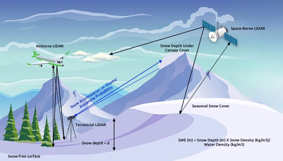
The cryosphere consists of frozen water, snow cover, glaciers, ice sheets, and permafrost. Due to its high albedo coefficient and reflection of sunlight, it plays a significant role in energy balance. In addition, due to the impact of the cryosphere on ocean current patterns, global air circulation, ocean temperature, and sea level, it is necessary to continuously evaluate the quantitative and qualitative changes of the cryosphere. Conventional methods of cryosphere measurement required the collection of field data and in situ observations, which were not efficient due to adverse weather conditions, accuracy of measurement, and lack of access to polar regions and natural glaciers. Methods based on remote sensing, especially LiDAR, are an answer to the challenges and limitations of field and conventional methods. Terrestrial and airborne LiDAR, installed on stationary and mobile platforms, can provide cryosphere information and ice and snow height data with high spatial and temporal resolution at the regional and global scale. The superiority of LiDAR data over conventional methods and even passive remote sensors has led scientists to turn to LiDAR recently for cryospheric studies such as snow cover, alpine glaciers, permafrost, and polar ice sheets (Bhardwaj et al., 2016). Among the LiDAR data, CALIOP is used for accurate identification of snow and ice cover on the surface of the earth and open waters of polar regions. CALIOP's long-term observations effectively separate the snow and ice cover from the surface of water and land, enabling the modeling of snow and ice melt and the investigation of climate change impact (Lu et al., 2017).
Fig. 9. LiDAR in Ice and Snow (Cryosphere) Detection: a visual guide to how different LiDAR systems measure snow depth under canopy cover and seasonal snow.
2. Conclusion
Water resources are important, and their role in the lives of humans, creatures, and plants is clear to everyone. However, valuable water resources have faced challenges in terms of quantity and quality during the past decades due to human and natural hazards. The development of remote sensing technologies, including LiDAR technology, has been able to help manage water resources more efficiently and simulate their processes more accurately. In general, LiDAR applications in water resources are divided into the nine following cases: coastal research and management, flood modeling and risk mapping, urban inundation modeling, high-resolution DEM, surface roughness mapping, bathymetry and submerged aquatic vegetation, analysis of water level, ocean measurement, ice and snow (cryosphere) detection, and hydrology analysis. Most past studies have investigated LiDAR applications for producing DEM with high resolution and improving flood modeling and forecasting. The applications of LiDAR in water science in each of the nine categories mentioned are not different from each other. For example, high-resolution DEM obtained from LiDAR can be indirectly used in other categories such as flood modeling and urban inundation. Each of the LiDAR applications in water resources can be through airborne or ground-based (terrestrial) LiDAR, depending on its application. The main challenges of LiDAR in water science are its high computational cost and time, high volume of data, and low accuracy in special conditions such as areas with dense vegetation and adverse weather conditions. It is expected that the challenges and limitations of LiDAR will be resolved in the future. Past studies show that airborne LiDAR has more applications in water resources due to its high processing speed and wider spatial coverage, but due to the more detailed nature of terrestrial LiDAR, it is possible to integrate airborne and terrestrial LiDAR and other remote sensing tools for a more accurate understanding of water bodies.
Challenges in the DEM Filtering Process
High Storage Volume
LiDAR in Surface Roughness Maps
High Resolution and Coverage of Spatial Details
Reliable Flood Forecasting
Weakness in Complex Areas
Inefficiency in Densely Vegetated Areas
LiDAR in Bathymetry and Submerged Aquatic Vegetation
High Accuracy in Bathymetric Data Extraction (about 10 to 15 cm)
Key Role in Water Resources Research
Decreased Bathymetry Accuracy in Turbid or Suspended Sediment-Laden Waters
Limitations in Mapping Submerged Aquatic Vegetation in Waters with High Turbidity
LiDAR in Analysis of Water Levels
Accurate Measurement of River Water Level
Estimation of River Flow and Flood Potential
Decreased Accuracy in Estimating Water Level as Measured Distance Increases
LiDAR in Ocean Measurement
Study of Quantitative and Qualitative Characteristics of Ocean Subsurface
Effectiveness in Measuring Depth of
High Computational Time
High Storage Volume
LiDAR in Hydrology Analysis
Improved Hydrological Analysis of Water Resources
Enhanced Performance of Hydrological Models
High Computational Time
High Storage Volume
LiDAR in Ice and Snow (Cryosphere) Detection
Provides High Spatial and Temporal Resolution Data for Cryosphere Measurement


Comments
No comments yet
Be the first to comment
Share your thoughts and start the conversation.