Tech-community water resilience report cover, showing a digital network over layered human profiles and the GA flag.
Share
Coastal Georgia is a region that is of great ecological, social, and economic importance in the Southeastern United States. It has barrier islands, estuaries, and tidal marshes that offer important ecosystem services, including support of biodiversity, storm buffering, fisheries, and capturing carbon (Barlow and Reichard, 2010). However, the issue of climate change and human actions, together, is increasing risks in the region. Water resources, which are already on the verge, are overloaded with rising sea levels, saltwater intrusion into aquifers, increasing and more severe storms, and explosive population growth (Panthi et al., 2022).
In this regard, the strategic collaboration of WaterLyst and GDG Brunswick will seek to combine the adoption of superior technological initiatives with effective community participation to enhance Coastal Georgia Water Resilience. This partnership aims at resolving some of the most important issues, such as Brunswick groundwater contamination, the predicament of saltwater intrusion facing Georgia, and the weakness of the aging water infrastructure by integrating innovations like remote sensing, predictive modeling, smart sensor networks, and nature-based solutions with local expertise and experience on the ground. In this combined endeavor, the article singles out the potential of data-driven tools, coupled with equitable community involvement in the development of simple, viable, and progressive pathways to improve the safety of water resources and greater resilience in the Coastal Georgia area.
The increasing pressures on the coast are not just future projections; they are a present reality felt acutely by those living on the marsh and those managing the city’s infrastructure. The risks outlined in this report are already manifesting as daily, season-after-season struggles:
“Our household is tucked close to the marsh, where water is always in the background—sometimes beautiful, sometimes pretty stressful. We’ve had flooded yards and ditches that back up. On top of that, when the ground is soaked, our septic system struggles, so we worry about backups and what might be seeping into the ditches and marsh around us. What I wish local leaders could feel is how constant and tiring it is to deal with this on your own, season after season. Even small fixes to drainage would go a long way for families trying to keep their homes safe and their property from slowly being eaten away by water.” (—Long-time marsh-side Brunswick resident)
This pervasive, personal challenge is confirmed by local officials managing the structural and safety impacts:
“When it starts to rain we know we have to go close roads. We're seeing streets flooding at high tide that weren't flooding five to six years ago.” (—City Engineer Garrow Alberson)
By 2060, the population of the coastal counties is expected to grow by almost 40 percent to over one million people, which will cause further stress to the already worn-out infrastructure and weak water systems (Water Resilience in Coastal Georgia Report, 2024). In addition to natural hazards, past industrial pollution still affects the water quality. Chloride levels in the Brunswick Upper Floridan aquifer in certain locations were more than 2,000 mg/L, much higher than the second drinking-water standard set by the U.S. Environmental Protection Agency of 250 mg/L, compelling people to use other water sources and expensive monitoring initiatives (U.S. Geological Survey, 2024). These issues reveal the urgent necessity of in-depth strategies that would unite technological innovation and community-based interactions to ensure long-term water security (Basack et al., 2022; U.S. Water Alliance, 2017). The use of advanced technologies, including remote sensing (Landsat, Sentinel, GRACE), sensor networks based on the Internet of Things, predictive models (e.g., MODFLOW, LSTM), and nature-based solutions (NbS), is changing the nature of water resources monitoring, management, and protection. These technologies provide the possibility to monitor in real-time, forecast scenarios, and make adaptive decisions to perk up resilience to extreme climatic conditions (Neumann et al., 2015). However, technology is not the solution to resilience. The world has shown that real development is possible when inclusive governance and local involvement accompany technical inventions.
Fig. 1. Geographic representation of the Coastal Georgia, USA region and its unique environment.
About the Contributing Organizations:
GDG Brunswick (Google Developer Group Brunswick) connects local technology, education, and sustainability leaders to drive innovative solutions for community impact in the Golden Isles.
WaterLyst specializes in advanced water management, leveraging technology-enabled monitoring and scenario planning to help communities optimize water use and build resilience to climate challenges. WaterLyst platform integrates expert consulting, global software training, data-driven product reviews, service provider vetting, and a location-based directory.
1. Coastal Georgia: Water & Climate Pressure
Coastal Georgia, which borders the Atlantic Ocean, is an area that has got ecological, cultural, and economic importance. This coastal area comprises barrier islands, estuaries, tidal marshes and low-lying communities that are very vulnerable to environmental change. The region has distinctive ecosystems such as the golden isles (St. Simons, Sea Island, Jekyll and Little St. Simons) that are a tourist attraction with a rich biodiversity. The ecosystems offer fundamental resources like buffering against storms, fisheries, and carbon sequestration, which are at increased risk due to rising sea levels, intra-brackish water infiltration, and the increase in the intensity of storms (Barlow and Reichard, 2010; Panthi et al., 2022).
Fig. 2. A real photograph from Coastal Georgia, illustrating the vulnerability of shoreline infrastructure to rising sea levels, stronger storms, and other climate-related pressures.
Coastal Georgia faces unprecedented water resilience challenges as the Brunswick and Golden Isles region prepares for a projected 39.9% population increase by 2060, rising from 715,000 to 1 million residents. This rapid growth is expected to drive increased water demand and place further strain on local infrastructure, making proactive planning and community engagement vital for long-term water security (Water Resilience in Coastal Georgia Report, 2024).
Fig. 3. Projected population growth for coastal Georgia from 2024 to 2060, with expected increases in water demand and infrastructure needs.
Historic industrial activities have led to contamination concerns, including polychlorinated biphenyls (PCBs) detected in local water systems. At the same time, sea level rise has increased by nearly 11 inches since 1950, averaging 3 mm per year, placing Brunswick and nearby communities at extreme vulnerability due to low elevations, tidal systems, and coastal exposure (Water Resilience in Coastal Georgia Report, 2024).
“When it starts to rain we know we have to go close roads. We're seeing streets flooding at high tide that weren't flooding five to six years ago.”
The Upper Floridan aquifer located in the Brunswick, Georgia area has suffered saltwater intrusion for almost over half a century, making its utilization very difficult as a dependable water supply. In portions of downtown Brunswick, portions of less than a few square miles, chloride levels are greater than 2,000 mg/L, which is far beyond the U.S. EPA and Georgia EPD secondary drinking-water standard of 250 mg/L. This has been an old contamination that has limited the furthering development of groundwater within the Upper Floridan aquifer, thus making people more dependent on other supplies, such as the surficial aquifer and the Brunswick aquifer system. To deal with this problem, the U.S. Geological Survey (USGS), together with the Brunswick-Glynn County Joint Water & Sewer Commission, is undertaking the monitoring of saltwater concentration, extent, and movement. Moreover, a predictive model is being built to evaluate the risk of future contamination under varying conditions of water use, which gives vital predictive insight on sustainable water management in the area. (USGS, 2024). These dangers emphasize the importance of integrative water management strategies that entail technological creativity and positive community involvement.
Fig. 4. Map of the study area, highlighting Brunswick on the Coastal Georgia region.
The Floridan aquifer supplies roughly 65% of coastal Georgia’s groundwater, serving as a critical resource for communities like Brunswick and the Golden Isles. This dependency highlights a growing vulnerability: saltwater intrusion—exacerbated by coastal development, climate pressures, and aging infrastructure—threatens to disrupt local water security and ecosystem health (Water Resilience in Coastal Georgia Report, 2024). This is not a hydrological-only challenge that has serious social, economic and ecological implications. The quality of drinking water sources will be compromised because of saltwater intrusion, and municipalities and industries will have to spend money on expensive treatment methods (Basack et al., 2022). Meanwhile, climate stressors, including sea-level rise, erratic precipitation, and increased temperature, decrease the natural recharge of aquifers and increase the rate of intrusion of salty water into freshwater areas (Cantelon et al., 2022).
Fig. 5. Water sourcing in coastal Georgia: comparison of surface water vs. groundwater supply (Source: Brunswick-Glynn County Joint Water & Sewer Commission)
The further penetration of saltwater is an ecological threat to the fragile ecosystem of the coast. Depending on freshwater inflow, wetlands, rivers, and estuaries can undergo changes in salinity levels, which threaten the biodiversity and change the conditions of habitat (Panthi et al., 2022). The changes may have a direct impact on local livelihoods, especially fisheries- and agriculture-related ones. In addition, the infrastructure is frequently inadequate in terms of dealing with these increasing demands because of age. That is why the process of implementing technological solutions is necessary. On-the-fly water quality monitoring systems, predictive model of saltwater intrusion trends that are driven by AI, enhanced technologies of desalination, and better demand management strategies represent the key avenues to enhance resilience (Basack et al., 2022). Combining all these can facilitate long-term water security as well as protect the ecosystem health in the coastal Georgia.
Fig. 6. Storm damage in Coastal Georgia, where fallen trees and debris highlight the vulnerability of residential areas to extreme weather events intensified by climate change.
1.1. Climate in Coastal Georgia
A reanalysis product created by the European Centre for Medium-Range Weather Forecasts (ECMWF) under the name of ERA5-Land Monthly Aggregated data, which is available in the Google Earth Engine Data Catalog, is a high-resolution product specifically intended to report land variables in more spatial detail than the standard ERA5. It has been created by running the land component of the ERA5 climate reanalysis, which combines global observations with model simulations via physical laws to create a complete and coherent account of the climate system on Earth.
The dataset is recent (1950-near real-time, approximately three months behind current conditions) and has a resolution of 0.1° (9 km), which is ideal in hydrological, agricultural, and climate change studies. ERA5-Land has over 50 variables, with 2 m air temperature, total precipitation and total evaporation/evapotranspiration being of central interest in water and energy balance analysis.
Fig. 7. Putting the pieces together: Integrated planning for Georgia's water future, informed by high-resolution ERA5-Land data.
The pre-calculations of the hourly ERA5-Land output on a monthly basis are made by summing the accumulated variables of the pre-calculated model, in terms of precipitation and evaporation, and averaging the non-flow variables, namely the temperature. This design enables effective exploitation of the dataset in climate trend study and long-term monitoring. Related data on the temperature, precipitation and evaporation was obtained through the ERA5-Land Monthly Aggregated product in this study to test the climatic variability and the long-term trends in hydroclimate in Coastal Georgia.
1.1.1. Average Monthly Air Temperature
The figure of average air temperature in Coastal Georgia between February 1950 and August 2025 indicates clear evidence of climate warming when the long-term average air temperature is considered. The mean temperature of each of these months oscillates within the range of about 5°C to 30°C and this goes to show how natural the coastal climate system is. Nevertheless, regardless of these oscillations, the regression line shows long-term warming. The estimated regression line is y = 0.00004x + 18.597, with y meaning the average temperature in °C and x being the index of time. According to this equation, the average temperature of the baseline was approximately 18.6°C in the early decades of the 1950s, and the temperature has been increasing steadily since that time at 0.00004°C per unit of time. This, when extrapolated in several decades, becomes a warming trend, which is slow but observable.
Such gradual rise in average temperature is in line with the overall scientific
Fig. 8. Average monthly air temperature in Coastal Georgia (February 1950 and August 2025), showing pronounced variability with a clear long-term warming trend (y = 4E-05x + 18.597), consistent with anthropogenic climate change.
Perception of climate change. The increase in temperature is consistent with the increase in intensity of the greenhouse effect due to anthropogenic carbon dioxide, methane, and nitrous oxide emissions. Although short-term peaks and troughs can be explained using natural cycles like the Atlantic Multidecadal Oscillation (AMO) or the El Niño-Southern Oscillation (ENSO), it does not explain the long-term upward trend represented by the regression line. More common high-temperature events occurring since the 1990s only underline the contribution of global climate change to the acceleration of local extremes.
The consequences of this heating process are catastrophic. To the ecosystems in Coastal Georgia, a rise in air temperature at a baseline level affects the phenology of plant and animal species, interferes with breeding, and heightens the pressure in sensitive ecosystems such as wetlands and estuaries. To human health, the increased rate of extreme heat spells is associated with the increased risk of heat-related diseases, especially in the vulnerable populations such as the elderly and children. It also directly affects agriculture, as the rise in temperature increases evapotranspiration and thus causes a rise in irrigation demand and decreased moisture retention. Increased warming, especially in urban areas due to the urban heat island effect, may supplement the background warming trend that was shown in the graph.
Fig. 9. Coastal Georgia shoreline with debris and erosion, reflecting long-term warming (y = 0.00004x + 18.597) that intensifies storms and accelerates coastal vulnerability.
The graph, based on resilience and adaptation, highlights the fact that there is an urgent requirement of climate-sensitive planning in Coastal Georgia. Investment in green infrastructure, restoration of wetlands as natural buffers, water-efficient agricultural practices and development of early warning systems against extreme heat events are some of the strategies that are needed to deal with the risks brought about by increases in temperature. Therefore, the pattern of changes in climatic conditions revealed by the equation y = 0.00004x + 18.597 over the long term is not just a mathematical representation; it directly reflects how anthropogenic climate changes are affecting local climatic conditions and creating new challenges for communities, ecosystems, and economies in the area.
1.1.2. Total Monthly Precipitation
The total monthly precipitation graph between the period of 1950 in the month of February and the year 2025 in the month of August gives valuable information about the variability of the rainfall and its long-term climatic variations in the region under analysis. The dataset exhibits big differences from month to month, and the values of precipitation vary between approximately 0 mm and more than 350 mm. This extreme version is characteristic of the areas that are subjected to seasonal weather patterns as well as extreme precipitation. In spite of this variability, the regression line fitted shows a weak upward trend in the precipitation over time.
Fig. 10. Heavy rainfall in Coastal Georgia, reflecting the region’s high month-to-month variability in precipitation (0–350 mm) and aligning with the long-term record that shows extreme events alongside a weak upward trend over time.
The equation of regression given below is y = 0.0005x + 80.787, where y is the monthly precipitation (mm) and x is the time index. The slope of 0.0005 mm per unit time shows a gradual yet constant rise in precipitation. When plotted over a time span of over seven decades, the trend is positive, which is an indication that the region is receiving more rain on average than it was in the early fifties. Although the initial precipitation level was around 80.8 mm per month, the gradual rise is a sign of a slight yet significant change toward wetness.
Fig. 11. Trend of total monthly precipitation in Coastal Georgia (February 1950 to August 2025), showing high variability with an overall long-term increase (y = 0.0005x + 80.787), consistent with an intensified hydrological cycle under climate change.
This trend can be seen through the existing scientific predictions that climate change not only increases the temperatures in the air but also the hydrological cycle. Warmer atmosphere contains more moisture (in accordance with the Clausius-Clapeyron relation, about a 7 percent increase in water vapor capacity with every degree of warming), and it may result in more intense rain events. This was anticipated by the rise in the extremes of rainfall as observed in the graph, e.g., the extreme high peaks following the 2000s. Although the long-term pattern might be humble, the increase in heavy precipitation is a signature of the impact of climate change on the dynamics of precipitation.
The implication is huge. The risk of flooding can be increased by increased precipitation, especially in urbanized or coastal areas where drainage systems may be stressed. Concurrently, increased rainfall does not automatically imply less risk of drought, as climate change also increases the duration of dry intervals between heavy rainfalls, thereby increasing climate extremes. This contrast between more intense rainfall events and dry spells belongs to the so-called hydroclimatic intensification, which is a feature of the warmer climate as identified by scientists. In the case of ecosystems, the increased variability of precipitation affects soil moisture and groundwater recharge and wetland and estuary stasis. In the case of agriculture, the changes may make crop production more uncertain by putting farmers at risk of both excessive waterlogging and shortages of rainfall.
The marginal line of increasing resilience shown by the regression formula y = 0.0005x + 80.787 can be addressed by the adaptation strategies, which consider the greater volumes of rainfall and the larger extremes. Sustainable drainage systems (SuDS), wetland rehabilitation and enhanced stormwater drainage systems play a very significant role in mitigating the danger of urban flooding. Meanwhile, water storage and conservation measures are necessary to cushion against the cyclical intervals of drought and downpour.
Fig. 12. Intense downpour in Coastal Georgia illustrates the increasing frequency of extreme rainfall events, consistent with long-term precipitation records showing strong variability and a gradual upward trend.
Finally, the figure indicates the way precipitation patterns in the area have changed during the past 70 years. Although variability is large, the overall, albeit slight, positive growth in total monthly precipitation, coupled with increasing extreme events of rainfall over the past decades, reflects the way climate change is reconfiguring the hydrological cycle. This draws attention to the need to incorporate climate projections into the water management, infrastructure design, and conservation of the ecological environment.
1.1.3. Total Monthly Evaporation
Another valuable way to look at the regional climate system is through the graph of total monthly evaporation in Coastal Georgia between February 1950 and August 2025. The data vary widely between about -20 mm and -150 mm, which shows variability by season and also varies because of the short-term weather variations. Nevertheless, even with this natural variability, the fitted regression line shows that the evaporation tends down over the long run. The regression line will be y = -0.0003x - 78.043, where y is evaporation (mm) and x is time. The pessimistic slope of -0.0003 means that there has been a progressive decline in the average monthly evaporation over the past 74 years. At the beginning of the record in the early 1950s, the evaporation at the baseline was approximately at -78 mm; however, as time progressed, the trend was towards lower values of evaporation.
Fig. 13. Trend of total monthly evaporation in Coastal Georgia (February 1950 to August 2025), showing high variability with a slight long-term decline (y = –0.0003x – 78.043).
This finding might seem counterintuitive at first, since increased air temperatures (as reflected in the monthly air temperatures graph in Costal Georgia) would be expected to increase the possible evaporation. The picture is, however, more clear when it is correlated with the precipitation trends.
The intensified rate of precipitation and an enhanced level of humidity in the air could in fact discourage the rates of evaporation, as the air is nearer to being saturated and hence less able to absorb more water vapor. That is to say that there is a possibility that warmer climate allows more evaporation to happen but when there is an increase in rainfall and the relative humidity is high, the actual evaporation taken at the surface can reduce.
Fig. 14. Observed rainfall and ponding in Coastal Georgia highlight changing hydrological dynamics, consistent with long-term evaporation records (y = -0.0003x - 78.043) that reveal a gradual decline in average monthly evaporation despite short-term seasonal variability.
Climate change-wise, this trend brings out the intricacy of the hydrological cycle. In Coastal Georgia, there are indications of:
Increasing air temperature becomes associated with global warming.
Moderately positive change in precipitation → in line with an active hydrological cycle of a warmer atmosphere.
Downward trend in evaporation rate may be caused by an increase in humidity and cloud cover with increased rainfall, which inhibits the evaporation even within increasing temperature ranges.
The effects of decreased evaporation are complex. The positive aspect is that reduced rates of evaporation can conserve the moisture in the soil, and the irrigation needs of agriculture, especially in wetter seasons. Conversely, decreased evaporation and increased precipitation could lead to an increased risk of waterlogging and flooding and decreased drainage capacity in agricultural and urban systems. Also, evaporation modifications affect the local energy balance and can cause the change of microclimates and land-vegetation-atmosphere feedback.
1.2. Projected Sea Level Rise under Different SSP Scenarios for Coastal Georgia (2020–2150)
The Coastal Georgia curve, created with the IPCC AR6 Sea Level Projections (SLP) dataset (in Google Earth Engine) of regionalized sea-level trajectories between 2020-2150 in SSP1-1.9, SSP1-2.6, SSP2-4.5, SSP3-7.0, and SSP5-8.5 (based on component-wise contributions: thermal expansion, glaciers, ice sheets, land-water storage, and vertical land motion) illustrates a rising trajectory, accelerating with time, In the case of SSP1-1.9, the rapid decarbonization means warming is limited and the increase is slowest and the steepest, and the end-century levels will remain relatively low (around -meter) and approach rather sub-meter levels by around 2150; nevertheless, greater tidal baselines, more often minor (sunny-day) floods and backwater effects in stormwater networks will demand adaptive drainage, living shoreline, and wetland migration pathways.
SSP1-2.6 has a similar but slightly steeper trajectory, where resilience planning should upgrade pumps, outfalls against backflow caused by rising sea-levels, bolster protection of aquifers against new saltwater intrusion, and allow marsh transgression to remain natural to maintain natural flood buffers.
SSP2-4.5 (a middle-of-the-road world) generates evidently higher and more rapid increase--crossing the 1 m mark in the second half of the century and moving onward--design requirements must shift the focus in favor of adaptation over protection.
SSP3-7.0 (high emissions with limited policy coordination) rises beyond mid-century to >1.4m, with an acceleration, corresponding to a high frequency of critical-depth exceedance in coastal drainage; chronic nuisance flooding becomes virtually daily in some areas; rapid shoreline recession and wetland drowning occur where migration space is occupied; and increased port, road, and rail vulnerability occurs. The resilience to this pathway must include hard options, such as selective elevation, district-scale floodable parks and storage basins, and tide gates with pump assist.
SSP5-8.5 (fossil-fuel intensive) gives the steepest curve, to about ~1.6 m about ~2150, when storm-induced and high-tide-induced compound flooding becomes more transformative than episodic, septic and shallow-utility failures become common, municipal wellfields will be threatened by saline intrusion, and salt-marsh complexes will be eroding as well as dislodging biodiversity, natural strategy-shifts will shift decisively to managed retreat to protect the most vulnerable areas.
Fig. 15. Projected sea-level rise in Coastal Georgia under five IPCC AR6 Shared Socioeconomic Pathways (SSP1-1.9, SSP1-2.6, SSP2-4.5, SSP3-7.0, SSP5-8.5) for 2020–2150, based on the IPCC AR6 Sea Level Projections (SLP) dataset
In every situation the moral is the same: sea-level rise is irreversible and accelerating, but its eventual elevation is policy sensitive and therefore the extent and cost of the necessary adaptation; incorporating these predictions into the design floods, drainage levels, groundwater management, and nature-based buffers can help Coastal Georgia achieve water services, mitigate the effects of floods, and protect critically important ecosystems on a shifting foundation.
2. New Knowledge and Tech for Water Resilience
Coastal Georgia is gradually embracing modern technologies in an effort to overcome the growing demands on the water resource. Conventional management methods cannot be sustained when there is rising sea level, saltwater intrusion, and fast urbanization. Rather, the data-driven systems and digital innovations are changing the perception of the local managers and communities in defining and addressing hydrologic challenges. The implementation of sensor networks built on IoT that offers real-time data on the level of groundwater, water condition and floods are one of the most promising fields. An example is the Smart Sea Level Sensor program in Chatham County, which was able to establish one of the most densely spaced sea-level networks in the world, which emergency responders and residents can receive flood alerts in minutes (Calderwood et al., 2020). These systems are also supported by remote sensing systems such as GRACE and GRACE-FO satellites in terms of groundwater storage, Landsat satellites and Sentinel satellites in terms of land-use and wetlands monitoring, LiDAR satellites in terms of high-resolution elevation maps, etc. (Tariq et al. 2023; Satizábal-Alarcón et al., 2024).
Fig. 16. Satellite observations track groundwater and surface water changes, supporting predictive modeling for coastal resilience
Meanwhile, predictive modeling has been established as a constituent of water resilience planning. Models based on physics (like MODFLOW) can predict the flow of groundwater and saltwater intrusion, whereas machine learning (including Long Short-Term Memory (LSTM) and Gradient Boosting models) can provide short-term predictions of streamflow and drought with accuracy that is usually higher than in traditional hydrologic models (Chakraborty et al., 2020; Diana et al., 2025; Kassem et al., 2025). Community engagement is also provided as a result of technology. Participatory mapping platforms, mobile apps and open-access dashboards enable residents to gain access to data, make local observations and control water-specific decisions. Programs such as Safe Water Together in Brunswick show that when communities are empowered with technology, the monitoring and stewardship become real outcomes of resiliency, which is most evident in underserved neighborhoods.
Recent policy shifts—such as the Executive Order halting funding for Georgia’s offshore wind initiative—remind us that community water resilience is deeply tied to energy choices. Offshore wind had the capacity to reduce pressure on water systems, since conventional energy generation can require vast quantities of water for cooling. When renewable projects stall, the region misses out on indirect resilience benefits (Environmental and Energy Study Institute, 2025).
Fig. 17. Offshore wind farms provide clean energy while reducing water demand from conventional power generation, supporting coastal resilience
Georgia’s coast is seeing a real transformation in the way water challenges are tackled. Over the past few years, tools like IoT sensors, new satellite systems, and even Digital Twins have come online—putting what used to be the stuff of sci-fi directly into the hands of local decision-makers (Georgia Tech, 2023). But smart water management isn’t just about new gadgets. Having accurate, timely information makes all the difference when water emergencies hit—local leaders need to know what’s happening to respond in ways that actually work for their communities (Cantor et al., 2021). Thanks to these new networked tools, Coastal Georgia neighborhoods can keep a close eye on changing conditions and step in early when climate-related threats begin to emerge—sometimes well before they become a crisis (Georgia Tech, 2023). Still, all the technology in the world won’t move the needle unless it fits with local goals, policies, and the people on the ground. That’s why it’s crucial to treat every new tool and dashboard as an opportunity for real collaboration—shaping practical solutions that reflect what local leaders and residents actually need (Cantor et al., 2021).
Fig. 18. Smart water treatment systems use IoT and AI to monitor quality and optimize management, enhancing urban water resilience.
In brief, the experience of the region indicates that water resilience is no longer a matter of physical infrastructure but tends to rely more on digital infrastructure. The combination of IoT sensors, satellites, predictive models, and open data platforms is a good way to transform communities to predict and manage water issues. We discuss below how these technology tools can interplay with the policy frameworks, world best practices, and community-based programs to create a multi-faceted road towards long-term resilience in Coastal Georgia.
2.1. Why Data-Driven Decision-Making is Essential for Resilience
To manage water resources in an era of the growing pace of climate change, data should be used more often in water governance instead of assumptions. New technologies, including IoT-based monitoring networks and artificial intelligence (AI), big data analytics, and digital twin platforms, are changing the way managers monitor the situation and prepare against disruptions. The technologies can support real-time monitoring and predictive analytics and adaptive plans, increasing the resiliency of operations in case of floods, droughts and saltwater intrusion (Dai et al., 2025).
Fig. 19. Data-driven decision-making empowers communities to choose adaptive, evidence-based strategies for long-term water resilience.
Good resilience is based on accurate, timely and relevant decisions. With adequate, accessible, useful, and used data, evidence-based environmental management is required, as Cantor et al. (2021) remark. They give the idea of decision-driven data systems, in which monitoring systems are modeled based on the demands of decision-makers, in which the information is available is not merely scientifically sound, but is also directly relevant to local governance and planning (Cantor et al., 2021).
2.2. Connecting Technology with Policy, Planning, And Community Action
Coastal Georgia’s water resilience thrives where smart technology, policy, and local engagement overlap. Chatham County’s network of Smart Sea Level Sensors sends real-time water level data straight to the cloud, where local emergency managers can check conditions instantly and issue timely flood alerts for the community (Georgia Tech Professional Education, n.d). Tools like MODFLOW and LSTM neural networks help planners simulate risks such as saltwater intrusion or aquifer depletion, letting local governments quickly adapt development policies or groundwater withdrawal rules when models predict heightened hazards ahead (U.S. Geological Survey, n.d.; Georgia Environmental Protection Division, n.d.). Success also depends on empowering residents as partners, not just observers. The "Safe Water Together" program and Brunswick’s green infrastructure initiatives give tools and data directly to local families—especially in underserved communities—so that monitoring and stewardship turn into real-world action and improved public trust (UGA Marine Extension, n.d.; Georgia Southern University, 2023). When residents have access to open data, can join hands-on labs, or take part in community workshops, they get a real say in shaping local water policy—instead of having decisions made for them. This kind of inclusive involvement helps strengthen equity and resilience for everyone, especially those most vulnerable to flooding and pollution (U.S. Water Alliance, 2017).
Fig. 20. Effective water resilience emerges where technology aligns with policy frameworks and active community participation.
2.3. Remote Sensing for Water Resources
Remote sensing is genuinely changing the game for water management in Georgia. Now, state and local planners don’t have to rely only on what they see from the ground—they can keep watch on saltwater intrusion, underground aquifer health, and even marsh dieback from miles above, using tools like Landsat, Sentinel, GRACE, and LiDAR (USGS, n.d.; Nature, 2022). One detail that really jumps out: in the past few years, scientists tracking satellite images each month have noticed that almost three out of every four salt marshes along Georgia’s coast are seeing below-ground losses. It’s the kind of finding that’s gotten local conservation groups and planners to sit up and take notice, knowing it’s time to act before those changes become irreversible (UGA, 2012; Georgia Tech, 2023).
Fig. 21. Satellite remote sensing enables global monitoring of water resources, supporting flood management, aquifer assessment, and ecosystem protection.
High-resolution LiDAR flights, which have mapped out thousands of coastal square miles and provided flood planners with a true "before-and-after" story with each storm or king tide, provide some of this insight (NOAA Fisheries, 2022). Not every area can be covered by satellite alone, though. That’s where Chatham County and its drone protocols come in: local teams now use drones to spot subtle wetland changes quickly—without harming sensitive wildlife or tramping through muddy habitats (NERRS Science Collaborative, 2022).
Perhaps most impressive is what’s happening on the ground in Chatham County: it’s now home to one of the world’s densest networks of water-level sensors. The folks at Chatham’s emergency management office could tell you just how vital these sensors have become. Picture this: every five minutes, the system updates them on exactly what's happening with the tides and water levels across the county. That means someone can pick up on brewing trouble right away and give neighbors and businesses a heads up—sometimes before most people even notice the water’s rising (Georgia Tech, 2023).
2.3.1. GRACE and GRACE-FO Analysis in Costal Georgia
The GRACE and GRACE-FO satellites detect minimal variations in the gravity field of the earth as they orbit Earth. As the weight of water is great, all the changes in the quantity of water held in the soil, rivers, lakes, or soils, produce a slight change in the gravitational pull. GRACE identifies the variations in these variations by determining the distance between the two satellites in its twin with high accuracy-a fraction of a micron. The higher the water storage level after the heavy rains, the stronger the signal of gravity, the lower the level of the groundwater due to droughts or over-pumping, the weaker the signal (Soltani and Azari, 2023).
Fig. 22. GRACE and GRACE-FO satellites detect changes in Earth’s gravity to measure groundwater storage and drought impacts worldwide.
These are the measurements presented in Coastal Georgia indicating evident seasonal and annual variations in groundwater storage. As an example, wet years increase the level of aquifer and minimize the risk of saltwater intrusion, whereas dryer years or heavy pumping of aquifer exposes communities to the danger of well shortages and stormwater strains. GRACE is a very powerful independent method of tracking long-term changes that cannot be detected by the traditional terrestrial techniques by essentially balancing the water under our feet. This understanding provides the local planners, utilities and community leaders with a scientific basis to predict risks, design stormwater better and manage groundwater more sustainably against climate extremes.
This value is an example of how the Equivalent Water Height (EWH, cm) changed over time in Coastal Georgia based on the GRACE/GFO satellite mission. The CNES, RL05, and DDK5 solutions were used to filter and eliminate noise in a dataset to make the data reliable. Keyvan Soltani conducted and analyzed the measurements and used post-processing filters and corrections to obtain the final time series. The results cover the years 2002 to 2025 and show forceful seasonal and interannual variations in water storage. It is possible to identify several different patterns. Significant declines in water storage occurred in and around 2007, 2012, and 2016, likely due to local droughts. On the other hand, it is clear that there were major increases in 2018, 2021, and 2023, likely associated with extreme precipitation, storms, or floods in the area. The long-term trend, which is depicted by the blue regression line, is almost flat, showing that there is no significant overall gain or loss in water storage over the two-decade period. However, variability has become even more pronounced over the last few years (especially since 2020), which can be seen as a sign that climate change is increasing its impact on the hydrological cycle.
Fig. 23. Equivalent Water Height (cm) over Coastal Georgia (2002–2025) from GRACE/GFO, processed with CNES, RL05, and DDK5
So, the data of EWH based on the GRACE/GFO methodology show a high level of evidence of short-term hydrological fluctuation in Coastal Georgia, with no long-term downward or upward trend. Nevertheless, the increasing scale of variability over recent years points to the possible susceptibility of the water resources in the region to the extremes associated with climate change.
2.4. Predictive Modeling and Scenario Analysis
Predictive modeling turns tech data into actionable future planning. MODFLOW, a 3D groundwater simulation, helps managers visualize water movement, aquifer health, and the impact of withdrawals across the region (USGS, n.d.; Georgia EPD, 2011). In practice, these models are grounded in decades of stories from the field—tracking real-world water use, rainfall patterns, and well pumping, and then using all this history to figure out where trouble might crop up as the region keeps growing (Georgia EPD, 2011).
Fig. 24. Predictive groundwater models simulate aquifer flow and saltwater intrusion, guiding sustainable water management.
Lately, the tools are getting even smarter. Researchers are using new AI tactics—like LSTM neural networks and Light Gradient Boosting machines—to make streamflow forecasts and spot saltwater intrusion way ahead of time, often with better accuracy than the old methods could manage (Van Essen Instruments, 2022). It’s that mix—satellites circling above, drones zipping over marshes, sensors planted by docks and culverts, and all the logbooks and lived experience from local teams—that really gives Georgia’s water managers clarity. Instead of just seeing distant patterns, now they can spot issues as they unfold right in their own backyard, sometimes even block by block (NASA, 2020).
2.5. Data Centers & Water Stress in Georgia
The rapid expansion of data centers—often invisible to most residents—can escalate water demand dramatically: some consume up to 5 million gallons daily, a volume that rivals towns of 10,000 to 50,000 people. In Newton County, Georgia, one such center reportedly triggered water deficits and even contamination of domestic wells, raising equity concerns. Industrial consumption during drought or peak demand can restrict household, agricultural, and ecological water access, highlighting the dire need for full transparency in industrial water and energy use. Stakeholders need access to official usage figures—including direct and indirect impacts—to craft effective, equity-oriented water policies. Experts urge the adoption of standardized reporting metrics like Water Usage Effectiveness (WUE) to build trust and accountability (University of Wisconsin–Milwaukee Center for Water Policy, 2024).
Fig. 25. Comparative water consumption showing that a single Data Center can consume up to 5 million gallons daily, comparable to a town of 10,000–50,000 people.
2.5.1. Artificial Intelligence and Machine Learning Models for Water Resilience
Emerging technology is rapidly reshaping resilience planning in coastal Georgia. Machine learning (ML) techniques—such as regression trees, random forests, and support vector machines (SVMs)—are increasingly used to predict groundwater levels, salinity, and drought events. These techniques are especially good at spotting meaningful trends in large, complicated datasets, making it easier for local water managers to make smart, timely decisions backed by real data (Georgia Tech College of Engineering, 2023; U.S. Geological Survey, 2024). Deep learning (DL) models—including recurrent neural networks (RNNs), Long Short-Term Memory (LSTM) models, and convolutional neural networks (CNNs)—have proven effective for forecasting trends over time, such as rainfall, streamflow, and aquifer pressure. For instance, recent research has found that LSTM models used locally can achieve Nash-Sutcliffe efficiency scores between 0.71 and 0.77 for predicting streamflow. That means these models are providing very reliable 10-day forecasts and are often more accurate than traditional hydrologic methods for important variables like streamflow (Hladik et al., 2016; Van Essen Instruments, 2024).
Fig. 26. Artificial intelligence supports water management by forecasting streamflow, monitoring aquifers, and improving resilience strategies.
Hybrid models leverage both physical hydrological models (like MODFLOW) with artificial intelligence, enhancing simulation accuracy for scenarios such as saltwater intrusion or population growth stress (U.S. Geological Survey, 2024; Georgia EPD, 2024).
Central to these advances is integrated data. Workflow integration now links NASA’s GRACE satellite data (for groundwater storage), precipitation data (GPM), high-resolution land use from Landsat/Sentinel, monitoring well measurements, and real-time water level updates from the region’s dense network of IoT sensors—such as Chatham County’s 40+ distributed nodes, the world’s densest water sensor network (Georgia Tech College of Engineering, 2023; One Hundred Miles, 2025).
Fig. 27. Machine learning enhances water resilience by optimizing groundwater, agriculture, flood management, and water quality systems.
The big benefits for Coastal Georgia include:
Early, actionable warning of saltwater intrusion, based on ML analysis of groundwater and tidal data
More accurate and timely flood forecasts from LSTM-based rainfall-runoff models
Seasonal drought risk predictions tuned to local aquifer and land use conditions
Scenario planning tools to guide infrastructure upgrades and anticipate the impacts of population growth
In sum, these innovations are positioning Coastal Georgia as a leader in evidence-based, anticipatory water management—translating world-class predictive analytics into local action.
2.5.2. Unlocking Hidden Sources: Advances in Offshore Aquifer Discovery
Recent scientific advances have revealed extensive offshore aquifers—subsurface reserves of freshwater located beneath the sea floor—along many coastal regions, including Georgia. These hidden resources, sometimes called submarine groundwater, can provide backup water supplies during drought or periods of increased demand. Advanced geophysical methods like marine electromagnetic sounding, seismic profiling, and integrated satellite-based analysis are assisting researchers in mapping these aquifers, estimating their size, and determining how they connect with onshore systems (Vitousek et al., 2023). As climate pressures increase, understanding and responsibly managing offshore aquifers may become a key part of resilience planning for coastal communities. However, tapping these sources brings ecological and technical challenges, making ongoing research, careful modeling, and data integration essential for future use.
2.5.3. Weather Modification: Exploring Cloud Seeding as a Water Management Tool
As communities seek more reliable water supplies, there is renewed attention on weather modification techniques such as cloud seeding. The process involves releasing tiny particles into the air to help clouds produce rain that might otherwise never fall. While results have varied over the years, recent improvements in technology, such as better weather modeling and more careful application, are bringing new promise to drought-prone areas. For coastal Georgia, cloud seeding could provide extra rainfall during prolonged dry spells. Still, it is essential to view cloud seeding as just one component of a broader approach that encompasses conservation and meticulous water management. Keeping track of environmental impacts and sharing updates publicly will help ensure that any effort is both safe and effective (French et al., 2018).
2.6. Real-Time Monitoring and Early Warning Systems
One of the most important elements in the contemporary coastal resiliency frameworks is represented by real-time monitoring and early warning systems, which are transforming the implementation of the reactive response system into the proactive, anticipatory one. The technologies offer a mix of continuous data gathering, instant processing, and enhanced modeling to avert, anticipate, and adjust to environmental threats prior to them turning into a disaster. Practically, real-time monitoring systems depend on a synergy of sensor networks, the Internet of Things (IoT), data-driven methods, and more recently Artificial Intelligence (AI) and Machine Learning (ML) algorithms to derive actionable insights based on big and dynamic data (Muppala, 2025).
Fig. 28. Four-layer architecture of a Real-Time Monitoring and Early Warning Systems detailing the connections between the Perception Layer (Sensors) and the Application Layer (Data Monitoring).
Such systems are useful in the case of Coastal Georgia, where sea-level rise, recurrent tidal flooding and stronger hurricanes are threatening issues. Tide gauges and precipitation sensors, which are connected to AI-based forecasting, can predict cases of nuisance flooding like those in low-lying regions like Savannah or Brunswick, enabling dynamic control of pumps, floodgates and stormwater systems. Likewise, there can be adaptive water management through real-time observation of saltwater intrusion into aquifers, and drinking water supplies will be safe. Nature-based solutions that utilize marsh and wetland monitoring also help assess ecosystem health, which is essential for maintaining the natural buffers that support water resilience in Georgia's coastal zone. These systems enable decision-makers to shift the response in a crisis to the realization of risks and resiliency through continuous monitoring, predictive analytics, and the distribution of early warnings. They do not only reduce the economic and social cost of climate-related hazards; they also increase the level of trust of people with open and science-based communication.
2.6.1. Internet of Things (IoT) Sensors for Water Quality and Quantity
The first layer in real-time monitoring and early warning systems includes a range of sensors that collect real-time data or near real-time data. There is a wide variety of sensors available for coastal monitoring and research, including optical sensors, Motion sensors, Conductivity Sensors, Magnetometers, Interferometers, Meteorological sensors, Pressure sensors, ADCPs (Acoustic Doppler Current Profilers), Hydrophones, Bioluminescence sensors, eDNA sensors, Water Level Sensors, Oil Spill Detectors, Chemical sensors, Wind Sensors, and Flood Monitors (Tonomy et al., 2020; Flores-Iwasaki et al., 2025).
Fig. 29. IoT-based water management system integrating real-time sensors with cloud computing to enhance monitoring, early warning, and coastal resilience.
2.6.1.1 Physical Parameters Data
Modern optical salinity sensors on buoys and satellites offer continuous, wide-area salinity data, while traditional methods rely on vessels. These IoT-enabled buoys could also be equipped with temperature sensors that help us understand biological processes, climate science, and disaster preparedness. However, they faced two major problems: 1. Sensor noise, which can corrupt data streams. 2. Low spatial density, which is because of the low number of sensors with intense sensor noise (Muppala, 2025). These sensors give real-time, high-resolution information on physical, chemical and biological processes, developing an overall picture of the dynamics of the coast. With several sensor types integrated, it is now possible to measure oceanographic conditions, identify anomalies, e.g., storm surge or oil spillage, and even measure ecological changes, e.g., using biological and chemical indicators.
Fig. 30. IoT-enabled coastal monitoring station with acoustic water level and environmental sensors powered by solar energy, providing real-time data on salinity, temperature, and oceanographic conditions to support climate and resilience studies.
The implementation of such multifarious sensor networks can be of great value, especially in the setting of Coastal Georgia. To illustrate, water level sensors and ADCPs may be used to predict the effects of tidal floods and storm surge on low-lying communities such as Savannah and Brunswick, whereas chemical and conductivity sensors could be used to detect saltwater intrusion into drinking water providing aquifers. Also, there are meteorological and wind sensors, which enhance the prediction of hurricanes, and ecological sensors like eDNA and bioluminescence detectors, which are essential to understand the well-being of wetlands and estuaries, which are vital in the defense against natural floods. Combined, these technologies can improve resilience by providing early warnings and information on infrastructure planning and protect the human communities and ecosystems along the vulnerable coastline of Georgia.
2.6.1.2. Chemical and Biogeochemical Sensors
Smart buoys added to the sensor network in the ocean provide near-real-time data that make in situ, long-term chemical monitoring of water possible. Sensors are able to continuously measure pH, chlorophyll, nutrients, dissolved organic matter, dissolved oxygen, and total hydrocarbon gases (Muppala, 2025). Chemical and biogeochemical sensors can provide high-frequency and spatially distributed data, thereby enabling scientists and managers to monitor water quality dynamics, identify harmful algal blooms, and assess ecosystem health much more accurately. Moreover, the instruments can also be used in predictive modeling work by connecting chemical signals to greater biogeochemical patterns and climate-driven shifts in the coastal environment.
Fig. 31. Examples of Autonomous Underwater Vehicles (AUVs) used for coastal monitoring, categorized by type: ROV-type, Torpedo-type, and Glider-type AUVs.
The implementation of these smart buoys can be especially advantageous in the case of the coastal waters of Georgia. Ongoing pH and dissolved oxygen assays aid in the monitoring of the risks of ocean acidification and hypoxia that pose threats to fisheries, and chlorophyll and nutrient sensors issue early warnings of eutrophication and harmful algal blooms. By implementing all these sensors in a broader real-time monitoring network, managers can increase water resilience and protect the integrity of the ecology and livelihoods in the communities that depend on healthy coastal ecosystems.
2.6.1.3. Pollution sensors
Pollution sensors consist of chemical sensors that are deployed on smart buoys that are part of the IoT network. Their goal is to monitor marine pollution in the context of oil spills. These sensors can work with constant monitoring of water chemistry and levels of hydrocarbons, which allows timely detection of pollution that leads to ecological harm in the long term. Once connected to real-time data systems, the pollution sensors will allow for early alerts, enabling a response and mitigation efforts to be implemented faster, minimizing ecological and economic effects of the pollution events (Cavanaugh et al., 2025).
Fig. 32. Smart buoys equipped with pollution sensors for real-time detection of hydrocarbons and oil spills, enabling early alerts and rapid mitigation to protect marine ecosystems.
The use of pollution sensors on smart buoys can be the key in the context of Coastal Georgia where ports, shipping lanes and offshore activities are likely to cause the risk of hydrocarbon contamination. They may be used to detect oil spills early, monitor patterns of dispersion and guide specific cleanup efforts. With the spill into bigger monitoring systems, pollution sensors enhance the resilience of coastal waters to defend fisheries, wetlands, and other tourism-driven economies, which rely largely on clean and healthy marine ecosystems.
2.6.1.4. Biodiversity sensors
To monitor biodiversity in the ocean and marine life, there are different types of sensors.
eDNA (Environmental DNA): this sensor collects DNA shed by organisms (eg., skin, waste) and provides information about the presence or absence of specific species.
Hydrophones: Hydrophones are underwater microphones that are for acoustic monitoring of marine ecosystems. Changes in acoustic patterns can indicate shifts in species abundance, migration, or ecosystem health.
Fig. 33. SeaWARRDD System Concept illustrating integrated marine monitoring using a smart buoy and the Navocean Nav2 ASV to collect comprehensive meteorological and water quality data.
2.6.1.5. Current Sensors
The current sensors are constructed to detect water velocity and water direction, which is essential information for the prediction of coastal and ocean processes. These sensors are crucial in assessing the movement of heat, pollutants, sediments, and floating debris and are important in the numerical models on the dynamics of ocean circulation and ecosystems. They also support the forecasting systems that enhance the safety of the navigation, pollution management, and disaster preparedness because they capture the real-time current data.
The Acoustic Doppler Current Profiler (ADCP) is one of the most popular tools for real-time current measurements because it relies on sound wave frequencies for water velocity profiles at various levels. ADCPs are especially useful since the devices can offer continuous and multi-dimensional observation of current patterns and thus become invaluable instruments in climate change studies, hydrodynamic modeling, and coastal resilience planning.
Fig. 34. Close-up of a large, spherical, yellow oceanographic buoy, highlighting the external, multi-sensor clusters used for advanced marine data collection in coastal waters
In the case of the coastal waters of Georgia, current sensors are of significance. They are able to monitor the redistribution of pollutants, debris, and sediments by storm surge and tidal currents, and their use is essential in keeping waterways open and preserving coastal ecosystems. Moreover, ADCPs contribute to resilience through flood forecasting, oil spill response, and design of sustainable coastal infrastructure that is resistant to changes in hydrodynamic forces in response to a changing sea level and climate changes.
2.6.1.6 Water Level Meter Sensors
Water level meters are the critical sensors used to detect the height of the water surface relative to a fixed datum, providing direct input for flood risk and sea-level rise modeling. The National Oceanographic and Atmospheric Administration (NOAA) and Water Level Observation Network (NWLON) are two well-known organizations that use acoustic- or pressure-based sensors to monitor water level.
Fig. 35. NWLON Sentinel coastal monitoring Station featuring a solar panel, antennas, and instruments for high-accuracy meteorological and oceanographic data collection.
Besides NOOA and NWLON, the Southeast Coastal Ocean Observing Regional Association (SECOORA) started to install a new network of water level meters that covers North Carolina, South Carolina, Georgia, and Florida (Hernandez et al., 2025).
Fig. 36. Map showing the network of coastal and ocean monitoring stations in the Coastal Georgia US, including SECOORA, Partner, and NOAA Stations used for regional data collection
2.6.2. Integration of local sensor networks with satellite and modeling data
While in-situ sensors provide localized and also detailed data, satellite technology offers wide-area and continuous coverage analysis. Programs such as Landsat, Sentinel, and NOAA satellites monitor shorelines, sea surface temperature, land cover, and vegetation changes, which complete local data and create a complete picture of coastal dynamics (Adewale, 2025). Satellites are used for large-scale monitoring:
Imagery satellites and lidar technology: Enable detailed mapping of coastal topography, elevation, and erosion risk.
Synthetic Aperture Radar (SAR): They capture coastal flooding, storm surges, and oil spills, even in harsh conditions such as storms or at night (Aslam and Abbas, 2025).
Altimetry and GRACE satellites: they measure sea-level rise and ocean mass changes, making them essential for long-term coastal resilience study.
Fig. 37. Satellite imagery shows cities in danger of sea level rising in Coastal Georgia.
On the other hand, Satellites also have the communication role in transforming data. Nowadays, more than 1500 marine buoys are active all around the world and transmitting real-time environmental data. The technology of two-way communication allows buoys to be updated, monitored, and programmed remotely (Røste et al., 2023).
2.6.3. Community benefits: Role of dashboards, mobile apps, and open-access data portals
The final step for the real-time monitoring and early warning system is visualization and dissemination. It is obvious that collecting data from buoys and satellites is not enough and those data must be translated to actionable data. This is where dashboards, mobile apps, and open-access data portals comes in.
2.6.3.1. The Role of Dashboards and Web Platforms
These systems combine various data sources, such as AI-based predictive systems, satellite images, in-situ sensor networks and IoT devices, into one overarching perspective that improves situational awareness. Dashboards convert the raw information into actionable knowledge by integrating the complicated datasets into easy-to-understand visuals. They enable users to see the risks in real time, draw dynamic maps, and point to the emerging threats under different climate and hydrological conditions. As an example, the Coastal Defense Pro idea shows how predicted water levels and flood boundaries could be shown in real time and which utilities, transport routes, and residential areas would be jeopardized and prone to flooding (Magoulick, 2025). The platforms have not only contributed to emergency response but also long-term resilience planning, allowing the simulation of scenarios, cost-benefit analysis of adaptation actions, and open communication with stakeholders.
Fig. 38. The role of Dashboards and Web Platforms in Water Resilience, visualizing the integration of key data points—such as Sea Level Rise and Groundwater Salinity—for public and managerial decision support.
Dashboards in the instance of Coastal Georgia might incorporate the forecasts of sea-level rise, storm surge, precipitation-groundwater-runoff, and Groundwater Salinity data to provide the decision-makers a comprehensive perspective of the coastal threat. This would enable the local governments to develop progressive adaptation plans, focus investments on flood control, engage the population through transparent and readily accessible risk communication mechanisms, and ultimately enhance resilience to water in the region.
Fig. 39. Screenshot of the Georgia Coastal Ecosystems LTER Data Portal, displaying Near-Real-Time Monitoring Stations around Sapelo Island, GA, and detailing the Station Type, Partners, and Data Update Frequency.
2.6.3.3 The Role of Mobile Apps and Hyper-Local Alerting
Mobile apps play a crucial role in delivering timely, targeted alerts during coastal hazards like hurricanes, floods, or wildfires. These tools work as part of a larger information chain: IoT sensors scattered across the region collect rainfall and water-level data, feeding it into weather services such as NOAA and the National Weather Service, which use advanced models to generate accurate forecasts. Local apps like WJCL then translate these forecasts into real-time, hyper-local warnings for area residents, providing storm tracking, flood alerts, and evacuation updates directly to smartphones (Silverman et al., 2022).
Fig. 40. Flood warning on mobile app: an example of early warning systems.
This warning system depends on local government as a central link—emergency management offices interpret the incoming data, coordinate response plans, and issue official guidance. Ultimately, the community responds with the support and resources provided. This chain—from sensors and models, through weather apps, to coordinated action—demonstrates how technology, media, and local leadership can come together to protect lives and property in coastal Georgia.
Fig. 41. Storm damage in Coastal Georgia highlights the importance of integrated early warning systems and coordinated local government response to protect lives and property.
2.7. Approaches to Enhance Coastal Resilience
Rising tides and powerful storms demand fresh thinking. This section explores practical strategies that help coastal communities bounce back and thrive, no matter what the future holds.
Coastal regions face mounting risks from sea-level rise, storm surges, and increasingly frequent extreme weather events. Strengthening resilience in these areas requires a shift from reactive measures toward proactive, adaptive strategies that integrate technology, governance, nature, and communities. This section highlights a range of innovative and practical approaches that can guide policymakers, planners, and local stakeholders in preparing for future challenges. From cutting-edge monitoring technologies and citizen-driven data collection to nature-based solutions, adaptive land-use management, and public engagement with science, these approaches illustrate how coastal resilience can be strengthened in diverse contexts. By combining these strategies, societies can better anticipate hazards, minimize risks, and ensure sustainable, climate-resilient development along coastlines (Assaf et al., 2023; Hart and Blenkinsopp, 2020).
Fig. 42. Coastal erosion in Georgia illustrates the growing impact of sea-level rise and storms, stressing the need for adaptive resilience strategies.
2.7.1. Emerging Approaches to Enhance Coastal Resilience
To achieve the goal of boosting coastal resilience to a satisfactory level by 2029, giving a high priority to technological advancement, collaborative science, and more community involvement to reinforce adaptation and readiness is absolutely necessary. This includes the expanded collection of coastal observation data through satellites, traditional observing programs, smart-city initiatives like Virginia’s StormSense network, and affordable community-based sensor projects. Additionally, advanced monitoring devices, such as satellite constellations (e.g., Kinesis), low-cost water level monitors, and biological and pollutant sensors, organized as IoT-enabled sensor webs, can be installed. In this vision, social media plays an essential role as a means by which alerts are transmitted. More importantly, however, a lot of research will be done in order to comprehend the ways people respond to emergency information so that tools provide results, not just information.
Fig. 43. Emerging coastal monitoring approaches—integrating satellites, IoT sensors, and community-based projects—enhance resilience by tracking sea-level change and storm impacts in real time.
The vision also entails the prioritization of the development of sturdy collaborative modeling platforms (e.g., COMT), the application of artificial intelligence (AI) to incorporate different datasets into applicable information, and the acquisition of ground truth during events by trained personnel to improve the accuracy of the models. Creating virtual collaboratoriums in which experts from diverse fields—such as computing, data science, environmental and social sciences, engineering, and policy—collaborate to produce new tools and insights that are useful to communities and government is also necessary. Moreover, the framework calls for independent evaluations of models in the aftermath of disasters, innovation in recovery tools and methods, and the systematic collection of data during events, as, right now, measurements like wave heights or water levels are taken only after disasters take place—a fact that limits rigorous model evaluation. Altogether, these steps outline a plan for major improvements in the way we prepare for, respond to, and recover from coastal hazards (Nichols et al., 2019).
Fig. 44. Collaborative modeling platforms and AI-driven tools provide new insights for managing coastal hazards, enabling communities and governments to better prepare for and recover from climate-driven impacts.
2.7.2. Citizen Science and Community-Based Monitoring
Thanks to the Internet, smartphones, and social media, people are more capable of gathering and spreading information that makes them better prepared against disasters. If communities are able to use affordable sensors, they can collect valid data in real-time. This helps them fill gaps when official datasets are delayed or missing. Communities aren’t just gathering raw data, but they are also helping with the analysis and the local choices. Citizen science enhances people’s awareness of risks, improves their scientific knowledge, and brings communities together. The collected data can also guide the officials’ policy making towards more resilient strategies (Paul et al., 2018).
2.7.3. Nature-Based Solutions
Natural solutions like restoring wetlands, reinforcing dunes, and creating living shorelines can be used to protect coasts from flooding just as effectively as traditional “grey” infrastructure, like seawalls or concrete barriers, at the same time that they improve the environment. Additionally, such strategies help protect species, people can enjoy them for their recreational value, and are gaining popularity as cheap adaptation methods around the world (UN Environment, 2017).
Fig. 45. Overview of Nature-Based Solutions (NBS) for Water Resilience, detailing strategies like Restored Marsh creation, Raised Berms, and the use of Ribbed Mussels to absorb flood waters, control erosion, and clean water.
2.7.4. Accommodation and Management
Instead of trying to block or fight natural hazards, these approaches focus on adjusting what people do in vulnerable areas, so that the risk is naturally lower. Deciding where people can or cannot build in hazardous areas, designing infrastructure by means of safer methods, and sediment management are among the strategies of these approaches. Thus, we are able to work with nature rather than against it. By working with natural systems, communities don’t need to depend as heavily on hard infrastructure like seawalls, which can be expensive and inflexible. (UN Environment, 2017).
Fig. 46. Accommodation and management strategies allow communities to adapt to natural hazards by working with ecosystems, reducing reliance on rigid infrastructure like seawalls.
2.7.5. Public Engagement with Science (PES) for Water Resilience
Water insecurity is becoming a bigger problem both in the U.S. and globally. Because of this, it is important—and also beneficial—to increase how the public interacts with and participates in science. This engagement can help improve sustainable water management. Public Engagement with Science (PES) includes sharing different types of knowledge and working together through collaborative methods. These efforts aim to create strong water management plans that are based on scientific principles from ecology, environment, and engineering. The core of PES is building a culture where all involved parties learn from each other. These parties might include scientists, utility managers, environmental groups, government officials, and everyday people who use water. Everyone has different interests and roles, but mutual learning connects them. When everyone is involved and learning together, the decisions made about water management are more likely to be backed by sound science and accepted by society.
A good example of how PES works in the real world is the Upper Flint River Working Group (UFRWG). This group has been working on water sustainability issues in Georgia for over seven years. The UFRWG shows that for engagement to succeed, the process must be adaptable to the different backgrounds and circumstances of all participants. These differences include how much money or knowledge they have, how much time they can commit, the language they use, and their political or economic situations. To engage people successfully, you need to plan carefully over the right period of time. This helps build important social outcomes like trust and cooperation, as well as real-world achievements such as saving water and improving infrastructure.
The work of the UFRWG shows important results that come from ongoing public engagement with science. These results are documented by Golladay et al., 2020:
Utilities are talking and working together better than before.
Problems with water shortages are spotted sooner, allowing people to act before things get worse.
A lot of efforts are in progress to use less water and save more.
Aggressive conservation initiatives to reduce water demand.
Instead of spreading treated wastewater on land, systems are changing to release it back into rivers after treatment.
Cities are using natural infrastructure to handle rainwater and reduce flooding.
Fig. 47. Public engagement workshops where community members, scientists, and officials collaborate on water management strategies, fostering shared learning and resilient decision-making.
2.7.6. Cloudbursts: The Deluge Challenge to Water Resilience
Climate change is increasing the number of cloudbursts, which are severe and high-intensity rains over a small area (e.g., > 100 mm in an hour) and have an acute risk of urban and coastal water systems (Geberemariam, 2025). Traditional stormwater structures in the form of sewers, drains, and channels are not often built to absorb such deluges, which results in flash floods, infrastructure failure, pollution, and extreme social and economic disturbance (Ho, 2023). A cloudburst in Coastal Georgia hampers the hydrological designs, which traditionally presuppose moderate precipitations, and may easily overwhelm systems, fill streets, endanger lives, cause damage to assets, and overload the wastewater overflow.
2.7.6.1. Solutions for Coastal Georgia
As one possible solution to this, we suggest that Georgia have a dual resilience strategy, Technological Shield + Human Shield, within the water resilience strategy, and thus have surplus extremes, such as cloudbursts, as well as drought and sea-level rise.
2.7.6.2. Technical Shield: Smart Infrastructure and Forecasting
State-of-the-art forecasting and sensor networks: Combine radar, satellite, and ground-based IoT sensors to identify the precursors of cloudbursts and simulate their development in real-time (e.g. neural-network and ensemble methods of cloudburst prediction) (Raghavendra et al., 2025).
Adaptive drainage, detention, and retention systems: Hybrid systems that combine surface solutions of the blue-green type (bioswales, permeable pavements, and green corridors) and additional underground tunnels and storage to absorb sudden inputs (as in the Cloudburst Management Plan of Copenhagen) are used (Cloudburst Management Plan, n.d.).
Dynamic infrastructure response: Predictively triggered real-time control of pumps, valves, and overflow bypass to avoid system overload or backwater in vulnerable areas.
Knowledge system integration: Develop decision-support systems that can combine multi-scale data (urban, neighborhood, and infrastructure scale) and model uncertainty during non-stationary climate regimes, addressing known gaps in urban resilience knowledge systems (e.g., including cloudburst-induced infrastructure) (Rosenzweig et al., 2019).
2.7.6.3. Human Shield: Community Preparedness and Engagement
Early warning and action plans: Implement mobile alerts, dashboards and hyperlocal warnings to initiate immediate protective measures during the event.
Resiliency education and capacity building: Partner with local schools, universities, and community centers to incorporate the curriculum on the risk of extreme rainfall, self-protection, and recovery techniques.
Open communication and trust issues: Share real-time information on rainfall, flood threat and infrastructural conditions with the general public using open access applications to inspire trust and immediate response.
Participatory resilience planning: Engage a community in scenario planning and local adaptation actions (e.g. retention areas at the neighborhood level, evacuation routes) so that infrastructure construction is consistent with social behavior design.
2.7.6.4. Global Lessons and Relevance for Coastal Georgia
The city of Copenhagen has set one of the best examples: it was created in response to a 1,000-year storm in 2011. The city created a Cloudburst Management Plan, which includes around 300 projects during a period of 20 years that integrate green-surface and underground solutions to reduce runoff (Cloudburst Management Plan, n.d.). They make a comeback of streets as flood routes, separate sewage and rainwater, and prioritize their investments so as to reach into the catchments most at risk of flooding first (C40, 2016). Academic research confirms critical challenges: knowledge systems for urban resilience often lag behind in accounting for non-stationarity, private property vulnerability, and integrated infrastructure modeling (Rosenzweig et al., 2019). Moreover, localized policy coordination (e.g., across city agencies) is essential; New York City’s efforts to embed cloudburst strategies in right-of-way planning illustrate how cross-institutional frameworks can amplify resilience (Ho, 2023).
2.7.6.5. Positioning Cloudbursts Within Coastal Georgia’s Water Strategy
Through cloudburst management as part of the coastal Georgia resilience outbreak, you can make the framework more than a drought/sea-level-only adaptation but a holistic cycle-based water resilience:
Enhances the construction of urban stormwater facilities to support the two ends of water supply.
Replaces the communities with the high-impact structure during crisis moments, but not just the usual circumstances.
It conducts early testing of smart infrastructure, including sensing, control, and dynamic adaptation, in areas vulnerable to drought stress and periodic deluges.
Proposes to learn from global experience (e.g., Copenhagen) of possibilities to be integrated into the contexts of Southeastern U.S. coastal hydrology and planning.
2.8. Urban landscape and Water Resilience
In the face of growing global challenges, such as climate change, rapid city expansion, and socio-economic weaknesses, resilient landscapes are becoming more and more important. Landscape resilience is a complex measure that combines the resilience of various systems across a large space. Since the scientific field focuses on how to keep landscapes sustainable over time, resilience is one of the most important topics being studied. Landscape resilience can be used as a good way to evaluate how sustainable a large region’s landscape is. At the same time, improving or increasing the resilience of landscapes can help them adapt to environmental changes and keep the ecosystem healthy and sustainable.
Fig. 48. Different Type of Urban Landscape where Water Resilience planning is required, ranging from developed parklands and water bodies to historical cityscapes and natural stream environments.
Coastal regions can be described as a social-ecological landscape (the SEL) in which a feedback relationship develops between the social landscapes and the ecological landscapes. The water-food system is affected by the SEL. Water ecosystems can provide the landscapes that function as wildlife habitats, livelihoods, and irrigation, based on water resources (Kim et al., 2017). Unsustainable landscape pattern changes often preceded by dramatic urbanization and serious ecological problems such as habitat fragmentation, desertification, soil erosion and loss of biodiversity. Landscape as a complex adaptive system, whose sustainability depends on resilience that arises from adaptive capacity (Wu, J., 2021). Urban landscapes play a crucial role in supporting municipal “ecological and social” systems (Barbosa et al., 2007). In urban areas, city parks, private gardens and street green space supply essential ecosystem services (Gill et al., 2007). The availability of green spaces impacts the qualities of the environment, such as air and water purification, wind and noise filtering or microclimate stabilization. Beside important environmental benefits, the existence of natural ecosystems, such as urban parks and forests, green belts and their components (i.e. trees and water), improve the standards of life in many ways and provide social and psychological services, which are very important for the liveability of modern cities and the well-being of urban residents (Chiesura, 2004).
Fig. 49. Aerial view of a complex urban landscape, illustrating the critical mix of green infrastructure (dense tree cover) and grey infrastructure (roads, buildings) essential for managing urban water resilience and stormwater runoff.
To increase resiliency, landscape architects employ a range of planning and design strategies that integrate the principles of adaptability, flexibility, and redundancy (De Groot et al., 2010). These strategies include:
2.8.1. Green Infrastructure
The green infrastructure is an interconnected network of green space that conserves natural ecosystem values and functions and provides associated benefits to human populations (Benedict and McMahon, 2002). Urban green infrastructure (GI) has been promoted as an approach to respond to major urban environmental and social challenges such as reducing the ecological footprint, improving human health and well-being, and adapting to climate change (Pauleit et al., 2017).
Landscape architects design and include features like rain gardens, green roofs, and bioswales (landscaped drainage systems) to control rainwater, lower the chance of floods, and make the water cleaner. These natural design solutions help ecosystems become stronger and more adaptable, and they also benefit people and the economy by creating beautiful, usable spaces for activities and by saving energy (Voghera & Giudice, 2019).
As one of the tested strategies, decrease in the coastal dune area extends the areas of coastal forests, coastal grasslands, and agricultural lands, decreasing the size of used areas; however, growth slows over time. This strategy led to building a green infrastructure network with coastal forests and coastal grasslands. As the green infrastructure network developed, the ecological connection of the inland region to the coast alleviates habitat fragmentation and helps the coastal ecosystem processes evolve, e.g., through pollination and wild animal movement with enhanced coastal resilience (Kim et al., 2017).
Past studies denote that urban green infrastructure can offer multiple functions for ecosystem and biodiversity benefits. These studies have suggested that multifunctionality concerning urban infrastructure services and functions is a prerequisite for targeting effective and impactful urban green infrastructure. Moreover, urban green infrastructure with multiple functions can offer socio-economic and environmental benefits (Korkou et al., 2023).
Fig. 50. Aerial view of an Urban Green Infrastructure around a River Showcasing Sustainable Urban Development, featuring green roofs, vertical gardens, and a central waterway lined with dense trees, demonstrating effective Nature-Based Solutions for resilience.
2.8.2. Multi-functional Landscapes
Landscape architects create outdoor spaces that have several purposes and can adjust when needs or conditions change. For instance, parks are made for people to enjoy, support wildlife, and help protect against problems caused by climate change. When landscapes serve several roles simultaneously, they help communities and ecosystems become more resilient (Cerreta et al., 2021).
Fig. 51. Bioretention: A Sample of Urban Green Infrastructure
Landscape architects use design ideas that allow landscapes to change and respond easily to new challenges or conditions. When planning, they think about future climate changes, how land use might change, and how society’s needs may evolve. They can help landscapes better fit new conditions by adjusting which design elements are included or how they’re used (Masoud & Holland, 2022).
Fig. 52. Cross-section diagram of a typical Rain Garden (Bioswale) used for Low-Impact Development (LID), showing how stormwater runoff percolates through layers of mulch and compost-amended soil for temporary storage and infiltration.
2.8.3. Water Management
Landscape architects include smart methods to save water, like collecting rainwater, reusing lightly used water (Greywater), and using irrigation systems that don’t waste water. Reducing how much water is used and controlling rainwater runoff make landscapes more protected against droughts and floods (Dolman, 2021). As cities are facing more extreme rainstorms, drier summers, and more expansion, people agree that water management in cities needs to change fundamentally.
Fig. 53. Modern building featuring an integrated living wall (vertical garden) as a form of Blue-Green Infrastructure (BGI) to manage urban runoff, reduce the heat island effect, and enhance the aesthetic resilience of the city.
New strategies that focus on “living with and making space for water” are being used around the world to handle everything from floods to droughts. Examples of these strategies are the Netherlands’ “Room for the River” project and Australia’s water-sensitive urban design (WSUD). Many places use nature-based solutions (NBS), sustainable drainage systems (SuDS), and Blue-Green Infrastructure (BGI, e.g. green roofs, swales, rain gardens, detention basins and ponds)—to manage water sustainably. These water management methods don’t just handle water better—they also provide benefits like more parks and green spaces, fun outdoor areas, prettier environments, and better control of floods, drought, heat, and pollution. (Dolman, 2021).
Fig. 54. Landscape Water Management utilizing three core strategies to enhance resilience: Rain Water Harvest, Smart Irrigation Systems, and the Reuse of Gray Water.
2.8.3.1. Rainwater Harvest (RWH)
Rainwater Harvesting (RWH) is probably the most ancient practice in use in the world to cope with water supply needs. In recent decades, as a result of new technological possibilities, many countries are supporting updated implementation of such practices to address the increase in water demand pressures associated with climatic, environmental, and social changes (Pandey et al., 2003). In urban areas, RWH consists of the concentration, collection, storage, and treatment of rainwater from rooftops, terraces, courtyards, and other impervious building surfaces for on-site use. Collected rainwater from rainwater collection systems could be used for different applications. One of them is landscape irrigation to follow the main goal of reducing consumption of drinking water from centrally supplied sources (Waseem et al., 2023; Belmeziti, 2024).
Fig. 55. A large, green, above-ground rainwater harvesting tank integrated into a modern residential landscape, illustrating a crucial element of sustainable water management and Low-Impact Development (LID) practices.
The science literature confirms that RWH could be a promising solution to overcome the water challenges that landscape and amenity gardens are facing. Some reports address the efficiency of rainwater harvesting for residential landscape irrigation in Florida in a sustainable way if sufficient storage were available (Wurthmann, 2019) and at a city scale that could meet 32% of urban outdoor irrigation demand for 8 months in a wet year in Arizona (Zhong et al., 2022). However, from an RWH perspective, landscape and amenity gardens differ from urban settings in terms of their timing of irrigation demand, the relative importance of the harvestable area compared to water demand, and opportunities to collect and store rainwater.
Consolidated scientific research of the last twenty years shows that RWH belongs to the large family of detention-based Low Impact Development (LID) or Sustainable Drainage System (SuDS) approaches and can be adopted as a complementary measure to reduce frequency, peaks, and volumes of urban runoff if systems are appropriately designed. The use of tank-based RWH systems, along with other at-source technologies, may help mitigate the impacts of urbanization on the stormwater drainage system by increasing distributed detention in urban catchments (Campisano et al., 2017).
Fig. 56. Residential Rainwater Harvesting Conceptual Model; showing how water is collected in a Tank, pumped, and reused for non-potable domestic tasks like flushing a WC, watering the Garden, and Car Wash.
2.8.3.2. Smart Irrigation Systems for Urban Landscapes
Smart irrigation systems are an advanced system designed to automate and optimize irrigation schedules based on real-time environmental data. These systems utilize controllers as a data connector by providing inputs such as weather conditions, soil moisture levels, and evapotranspiration rates to determine the appropriate amount of water required for irrigation (United States Environmental Protection Agency [EPA], 2016).
Fig. 57. A smart irrigation controller (sensor device) installed in a garden, representing the use of Smart Irrigation Systems and IoT technology to optimize water delivery and enhance efficiency in Landscape Water Management.
By adjusting watering schedules accordingly, smart systems help prevent overwatering and ensure that plants receive the right amount of moisture. With smart irrigation, there is no or less human involvement, and the resource of water is only used to the extent to which it is required. The main key benefits of using a smart irrigation system for an urban landscape are:
1. Water Conservation: Smart irrigation can significantly reduce water usage by ensuring that watering occurs only when necessary through their precise controller device. According to the EPA (2016), these technologies can reduce outdoor water use by 20% to 50%.
2. Efficiency: Traditional irrigation methods often lead to water waste due to overwatering and evaporation losses. Research indicates that smart controllers can improve Irrigation Efficiency, allowing for more precise application of water where it is most needed—the root zone of plants (Sales Dantas et al., 2025)
3. Enhanced Plant Health: Efficient irrigation practices enabled by smart irrigation controllers contribute to healthier plants. Plant health does not strictly increase with water application but has an optimum point such that watering rates above this point result in lower plant health. And many water users irrigate above this optimum point, suggesting opportunities to save water without negatively affecting plant health (Shurtz, et al., 2022)
Fig. 58. Smartphone display showing remote control of a Smart Irrigation System, allowing a user to manage different watering zones (stations) to optimize water usage in a large landscaped area with sprinklers.
2.8.3.3. IoT-Enabled Sensors and Automated Watering Technologies
With regard to the implementation of IoT devices, the communication technologies used could be considered as a vital and imperative point to attain successful operations. The main technologies that are used in IoT for irrigation could be classified into two categories. The first one could be regarded as the devices that function as nodes and lead to forwarding or transmitting small data at short distances along with having low consumption of energy. Consequently, the other devices are the ones that have the ability to transmit huge amounts of data over long distances, having high-energy consumption. There are various wireless standards that could be used in the communication of IoT devices, and they could generally be classified between devices that communicate at long or short distances (Abagissa et al., 2018).
Fig. 59. Conceptual framework of a Smart Park Irrigation System, demonstrating how Cloud-based processing integrates Soil State (Moisture/Humidity), Air Temperature, and Weather Forecasts to generate precise Water Recommendations for sprinklers.
The second one encompasses notable technologies that emerged more recently, including Long Range (LoRa) and Message Queuing Telemetry Transport (MQTT). LoRa provides very long ranges, and this has led to making this technology highly feasible and useful for secluded areas that do not have any service. On the other hand, although MQTT has also resulted in being a widely spread protocol, as it has low overhead and low power consumption, it is not being highly used for an irrigation system as yet (Munir et al., 2013).
There are various benefits associated with IoT systems in irrigation and some of them could be considered as overall water consumption reduction, high cost-efficiency, high performance efficiency, lesser energy consumption, lesser wastage of crops, and more. One of the main benefits of IoT systems in irrigation is associated with lower water consumption. Furthermore, most of the work related to irrigation is automated through such an approach; only the required amount of water is utilized for the irrigation process, and less wastewater takes place. In traditional ways of irrigation, where most of the handling and operations were carried out manually, an ample amount of water was wasted in the irrigation process where human intervention was required. Although high cost-efficiency is one of the other benefits linked to it, as lesser water utilization and precision in the process allow saving costs and overall expenses. Energy consumption is also reduced significantly, as machines have to run for a lower amount of time, and planned intervals take place during the process that lower the utilization of overall energy. IoT systems, when combined with irrigation systems, could enhance landscape quality by optimizing the use of resources such as water and energy.
Fig. 60. Example of IoT-Enabled Irrigation in an urban park, where networked sprinklers (signified by wireless icons) and remote monitoring via a laptop enable precise water allocation based on real-time data for efficiency.
2.8.3.4. Integration of Weather Forecasting and AI in Urban Irrigation Management
Artificial intelligence (AI) is regarded as the technology that is being used by most organizations for varied purposes. The development of Artificial Intelligence (AI) systems may provide tools for the large-scale analysis of time series data. Coastal resilience, including the provision of actionable information from AI, will involve disparate data from thousands of data sets and computation of nonlinear relationships between variables (Nichols et al., 2019). Through the use of AI, optimization of available resources becomes more feasible, along with gathering information related to the plants, such as diseases or corrected growth of them. A related technique in this to assess the collected data from the sensors to carry out the irrigation-related activities is fuzzy logic. This technique is employed to enhance irrigation scheduling and manage the drainage . Machine learning is one of the other techniques used in irrigation systems to carry out predictions. The techniques of prediction are used to assess the amount of available water for irrigation. This allows improving the irrigation process through foreseeing the probable adversities that could take place and how the risks must be managed to ensure optimum work efficiency (Donzia et al., 2022). Some of the benefits that could be linked with machine learning could therefore be regarded as water usage reduction, increased profits, and improved plant health with precise amounts of irrigation (Obaideen et al., 2022).
Fig. 61. Aerial view of a modern city demonstrating Sustainable Urban Development, characterized by the strategic integration of extensive green infrastructure (tree lines, medians) alongside dense high-rise development to enhance urban resilience.
There are various issues in the agriculture field, like plant diseases, lack of storage management, pesticide control, weed management, lack of irrigation, and water management, and all these issues can be resolved by using various artificial intelligence methods. Machine learning improves the overall activities and processes related to irrigation through algorithms and allows achieving the performance objectives. Machine learning further supports predictions for irrigation patterns, which are mainly based on weather and plant scenarios (Tseng et al., 2019). Predictions could be directly associated with the usage of machine learning, as it assists in taking measures and adopting strategies considering the probable activities that may take place in the future. These predictions therefore eventually allow taking necessary measures that could support the irrigation process in the long run (Khelifa et al., 2015). There is some research that investigated the integration of different machine learning models to find the optimal irrigation decision management. The precision irrigation systems could be used to control the changing environmental circumstances in an adaptive manner (Elavarasan et al., 2018). Various machine learning applications have been studied in literature, namely crop management, livestock management, water management and soil management
Fig. 62. Conceptual diagram illustrating Artificial Intelligence (AI) as the central processor for integrating diverse data streams, including climate, water quality, and IoT sensor data, for advanced environmental monitoring and Weather Forecasting.
2.9. The Role of MOFs in Sustainable Water Management
Recently, metal-organic frameworks (MOFs) have become a game-changer in the context of porous crystalline frameworks capable of more easily enhancing water resilience approaches, particularly in difficult coastal settings. Nobel Prize Nobel Prize 2025 Susumu Kitagawa, Richard Robson, and Omar Yaghi were awarded the 2025 Nobel Prize in Chemistry, which is a circumstantial recognition of their immense potential in capturing, storing, and releasing molecules in a selective manner through the frameworks of metal-organic (Nobel Prize Official Press Release). MOF-based strategies would be useful in addition to conventional water supplies and resilience strategies in the coastal setting of Georgia, where salt intrusion, intermittent droughts, and storm-induced salinization are placing a strain on freshwater provision.
MOFs consist of inorganic clusters of metals (nodes) that are bound to organic connectors, creating a long and highly porous structure. This modular design enables them to have unprecedented tunability in pore size, surface chemistry, and adsorption behavior (see, e.g., MOF-water sorption reviews). Hydrolytically stable MOFs have been designed in the context of atmospheric water harvesting (AWH) as sorbents to obtain moisture regardless of the relative humidity and store it, which can be later released upon slight heating or other external stimuli (Zheng et al., 2024; Huang et al., 2022). Already the incorporation of MOFs into the prototype equipment has already produced encouraging performances: a MOF-graphite composite harvester has proven to have a performance of approximately 0.1 L/kg/MOF/day in desert conditions (Hanikel et al., 2020). Newer designs with cooling-assisted sorption have been found with productivity as high as 7.75–22.8 L H₂O per kg of MOF per day in varied climates, even in low-humidity conditions (Feng et al., 2024). The developments indicate that water capture with the aid of MOFs can be used to address freshwater scarcity, especially along semi-arid or brackish coasts.
Fig. 63. Diagram of a Monocyclic and Passive system for Atmospheric Water Harvesting, which uses a MOF-Graphite Mixture in a Water Sorption Unit to passively collect water vapor at night and release it as liquid water using solar heat during the day.
n terms of resilience planning, a hybrid approach to MOF-based AWH and coastal nature-based infrastructure (marshland restoration, living shoreline, and dune systems) can be considered as a solution to reducing the amount and quality of water during the conditions of climatic stresses. Coastal ecosystems serve as storm surge resistant, salinity intrusion buffering, and groundwater recharging (e.g. marshes and dunes absorb overflow). Simultaneously, MOF systems would be able to extract atmospheric water, which would provide a distributed and decentralized water supplement during dry periods or saltwater intrusion. In regions such as coastal Georgia, where seasonal change and storm influences might impair traditional freshwater supplies, the resilience of MOF atmospheric harvesters would be increased.
Fig. 64. (a) Schematic representation of the integrated configuration of the passive system. (b) Diagram of the active system. (c) Photograph of the prototype device operating under active conditions. (d) Schematic representation of the adaptive system (Huang et al., 2022)
However, resolving several issues is necessary to achieve full-scale implementation in a coastal environment.
Stability during exposure to humidity or salinity: Most MOFs are destroyed during contact with water or salts, and only those frameworks that are water-stable (or post-synthetic) (e.g., coated with hydrophobic coatings) can be used in the long term (Wakekar and Das, 2024).
Energy and cost considerations: MOF devices need to meet low-energy requirements to make them practical, have high cycling performance, and have a satisfactory cost per liter of water produced (Ibrahim et al., 2024).
Connection to coastal infrastructure: The location, service, and connectivity of infrastructure to existing water facilities (e.g., wells, storage, distribution) should be designed to ensure that corrosion and fouling do not occur (e.g. in salty or coastal environments) and that the aerosols of salt do not present a risk to the biomass.
Scale and climate adaptation: The climate of Coastal Georgia (temperature, humidity, wind, precipitation) determines the best choice of MOF, and system design field trials and regionally tested models are required.
2.10. Subsea Freshwater Reservoirs: Unlocking Hidden Coastal Water Resilience
Recent ocean-drilling findings have revealed a new dimension of the phenomenon of coastal water resilience, which is the existence of large freshwater or low-salinity groundwater reservoirs sequestered in the sea floor, commonly known as offshore freshened groundwater (OFG). While largely unexplored, these reservoirs hold intriguing potential to tackle water security concerns in coastal regions like Georgia.
There is evidence that there are passive and active types of the OFG systems. Passive reservoirs can be described as paleo-aquifers that are recharged by lower sea-level periods, whereas active systems are hydrologically connected onshore and offshore groundwater systems (Paldor et al., 2024). The IODP Expedition 501 is a landmark project in which a drill was made off the coast of Nantucket to successfully recover cores of drinking-potable salinity water, marking the existence of freshened groundwater under the continental shelf (HALLMANN, 2025).
Fig. 65. Conceptual diagram illustrating Subsurface Geophysical Mapping towed from a vessel, used to measure electrical or magnetic fields (orange lines) for detecting and mapping Subsea Freshwater Reservoirs (SWRs), representing an innovative approach to increasing water resilience.
The economic rationale is that at times of lowered sea level (Pleistocene glacial maxima), rainfall percolated into coastal sediments, which were then subsequently covered by water, entrapping freshwater within impermeable marine clays or sediments (IODP, n.d.). Additionally, contemporary alongshore groundwater movements and hydraulic gradients could continue to cause the flow of freshened offshore water or vice versa (Knight et al., 2021). The main techniques of differentiating between freshwater-saturated pore zones (increased resistivity) and saline porewater include geophysical techniques, including controlled-source electromagnetic (CSEM) surveys and resistivity inversion (Thomas et al., 2023).
2.10.1. Potential Benefits & Risks for Coastal Georgia
In a region such as coastal Georgia, where saltwater encroachment, rising seawater elevation and periodic droughts are a problem, OFG reservoirs, therefore, create a relatively unutilized yet theoretically important buffer:
Additional freshwater supply: Supplying from marine reservoirs would imply that low-salinity water stores are available only after pressuring overused onshore aquifers or desalination facilities.
Salinity intrusion: Light production out of offshore idle field desalination facilities may reduce the inland suck-off effect that exacerbates the intrusion of salty water into coastal aquifers.
Temporal resilience: Underlying water reservoirs can experience a significantly lower turnover rate than surface aquifers and provide more stable storage regardless of climatic/sea level changes.
2.10.2. Challenges that should be evaluated
However, an evaluation of numerous challenges is necessary (Paldor et al., 2024).
Replenishment and sustainability: most of the OFG systems are remnants of previous recharge processes—current recharge could be insignificant or even absent. Therefore, extraction can be the simple mining of a limited resource.
Hydraulic connectivity and mixing: Two-water bodies Interfaces between fresh and seawater can be beneficial; however, pumping may cause saltwater intrusion into freshwater bodies or result in saltwater mixing.
Engineering & entry: Completing our offshore wells and drilling, as well as managing corrosion, is more difficult and expensive than the traditional groundwater infrastructure.
Environmental and regulatory issues: There are governance issues related to the effects of the submerged freshwater on marine ecosystems, structural stability of the seabed and legal ownership.
Uncertainty in characterization: To date, the topic is only covered by several pilot sites; heterogeneity, scaling, and mapping are the significant gaps in knowledge.
2.10.3. Outlook & Research Agenda
To determine their application to the coastal Georgia area, a set of steps is required:
The shelf side margin of Georgia (high-resolution geophysical mapping (CSEM), resistivity, seismic).
Sampling geochemistry, isotopic age, and hydraulic properties of pore waters: sample the depth by drilling and coring.
The process involves transfusion between groundwater and seawater flow, numerical modeling of salinity fronts, and sustainable groundwater exploitation.
Combine the sea-level rise predictions with coastal hydrology to evaluate risk and benefit trade-offs.
We are conducting a pilot demonstration of the well systems to ensure the maintenance of extraction rates, water quality, and system economies.
Use of MOF-based methods to optimize offshore freshwater recovery and better salinity management using advanced adsorption and filtration materials.
Partnering with Georgia Tech, Savannah State University and local schools to enhance STEM programs on OFG systems and coastal water resilience.
Creation of bilingual education toolkits and visual means of communication to facilitate the ideas of people and community in the formulation of policies that relate to the agenda of the OFG.
Summing up, coastal hydrology provides a new frontier location, where subsea freshwater reservoirs may alter the way we conceptualize that sense of resilience in rising suggestive circumstances of rising sea and growing water agony. In the case of the coastal region of Georgia, it is not whether they exist; rather, it is whether we can find them and appropriately define and take good care of them in order to properly develop it as a diversified water pool.
3. Community Action & Local Engagement
In response to rising demand, the Brunswick-Glynn County Joint Water & Sewer Commission reported total operating revenues of $41.6 million in 2024 (a 9.3% increase from the prior year), water sales reaching $12.4 million (up 7%), and secured a $15 million GEFA loan to upgrade wastewater treatment facilities. These investments reflect both expanding community needs and ongoing efforts to modernize regional water infrastructure (Brunswick-Glynn County Joint Water & Sewer Commission, 2024). To show how everyday actions can directly contribute to water resilience alongside these infrastructure investments, here’s a summary of common water-saving behaviors and their monthly impacts:
Table X. Common Water-Saving Actions and Monthly Impact
Action
Water Saved (per month)
Shorten shower by 2 minutes
150 gallons (EPA, 2025)
Install low-flow faucet
58 gallons (EPA, 2025)
Turn off water brushing teeth
25 gallons (EPA, 2025)
Install low-flow showerhead
Up to 830 gallons (EPA, 2025)
Run only full loads of laundry
200 gallons (SJRWMD, 2021)
Fix one leaky toilet
90 gallons (NHTMA, 2011)
Source: Adapted from EPA (2025), SJRWMD (2021), and NHTMA (2011).
3.1. Localizing Resilience: Integrating Community Knowledge in Coastal Georgia
The development of water resilience involves the proactive participation of local communities in decision-making and governance activities. While technology provides powerful, real-time data, local residents hold crucial, context-specific knowledge of historical flood patterns and infrastructure vulnerabilities. Integrating this perennial knowledge with advanced scientific models is key to generating context-sensitive and sustainable water management strategies (Ali and Kamraju, 2024).
To ensure the technology developed by the WaterLyst and GDG Brunswick collaboration is truly effective and equitable, our current focus includes hyper-local engagement strategies:
Citizen Science for Data Gaps: We plan to explore launching a pilot program in the Brunswick area that could engage residents in essential monitoring tasks, such as recording high-water marks during storm events or reporting localized water issues. This crowdsourced data would strengthen our predictive models (e.g., MODFLOW) with validated, real-world observations.
Community Mapping Workshops: We intend to investigate hosting dedicated workshops in vulnerable neighborhoods to gather qualitative data on infrastructure needs and historical water challenges. This local expertise would inform the development and optimal deployment of sensor networks.
Prioritizing Equitable Access: All data visualization tools and model outputs will be designed with community usability in mind, ensuring transparency and facilitating local governance decisions on resource allocation and long-term planning.
Participatory water management systems see the involvement of local actors in the different phases of the decision-making process, such as monitoring, planning, implementation, and evaluation. It improves transparency, ownership, and accountability and can contribute to adaptive responses to environmental uncertainty In addition, adaptive governance is inextricably connected to community empowerment, in which more flexible, inclusive, and learning-oriented institutions are more adept at responding to the water challenges posed by climate (Saikia & Jiménez, 2023).
Fig. 66. "Conversation Workshop" in progress, illustrating the concept of Empowering Local Communities in Decision-Making to ensure stakeholder buy-in, local knowledge integration, and successful implementation of water resilience strategies.
Recent findings demonstrate that community outreach with the assistance of citizen-based science projects substantially strengthens data quality, community awareness, and long-term management of water resources. Through this kind of cooperation, the interaction can help bridge the divide between local observations and scientific modeling, fostering resilience on multiple scales (Vermeij et al., 2015). Nevertheless, a successful engagement is frequently accompanied by various obstacles, such as imbalanced allocation of power, capture of the elite, poor institutions, and inferior understanding of rights and accountabilities by the locals (Shunglu et al., 2022). Consequently, inclusion in decision-making structures involving equitable representation of marginalized and vulnerable populations is a mandatory step towards realizing true community-based water governance and sustainable resilience solutions.
3.2. Citizen Science and Participatory Monitoring
Citizen science and participatory monitoring have become potent opportunities to increase water resilience by closing the divide between academic research and the community. The strategies empower local citizens, farmers, and other stakeholders to gather, disseminate, and analyze water-related information, including rainfall, water quality, and altered stream flows. Citizen science enhances adaptive water governance by decentralizing the data collection process and by linking small-scale observations to larger hydrological units, thus enabling a prompt response to changes in the environment (Buytaert et al., 2014). From a monitored area, participatory monitoring is able to enhance the spatial and temporal concentration of hydrological data, particularly at areas that have low conventional monitoring networks. Locally produced data enables informative measurement of local hydrological activity, complemented by satellite-based and modeled observation (Raymond et al. 2010). Moreover, citizen engagement in water surveillance can improve environmental literacy, promote stewardship and build trust between civilians and institutional actors. Such a participatory process is critical to ensuring the development of a climate resilience dynamic on a longer period in water systems (Miralles-Wilhelm et al., 2023; Ramírez et al., 2023).
Fig. 67. Citizen Science and Participatory Monitoring
Latest innovations in online platforms, apps, and sensors that are connected to IoT have made even participation in the system of water monitoring even more possible. They will be used to enable real-time collections, display, and feedback channels that empower local users to make informed decisions and policymakers to use community-elicited information to adapt management schemes (Paul and Buytaert, 2018). To scale up citizen science projects, however, sufficient technical education, financial resources, and data verification tools are needed to guarantee sustainability and scientific integrity in the long run. Simply put, citizen science and participatory monitoring democratize knowledge about the environment, strengthen transparency in water governance, and foster mutual solution coproduction among scientists, policymakers and citizens. Not only does this synergy enhance water data quality and availability, it also creates collective adaptive capacity, important building blocks of a resilient water management system (Brouwer et al., 2018; Walker et al., 2020).
3.3. Building Trust Through Transparent Communication
Open communication is critical for building trust among stakeholders and ensuring the long-term sustainability of water governance systems. Trust, in terms of water resilience, works as a social as well as an institutional premise of collective action. The open disclosure of information and clear communication of decisions between the communities, policymakers, and scientists can result in mutual understanding and responsibility; these two factors are critical to adaptive and participatory water management (Pahl-Wostl, 2017). Trust-building involves perpetual point-to-point interaction mechanisms that encourage tolerance and dialogue rather than unilateral information delivery. It is considered to engage citizens not only as followers of information but also as participants in the dialogue concerning water policies, the management of risks, and adaptation techniques. This open interaction promotes legitimacy of water institutions and heightens adherence to conservation best practices, not only in times of scarcity or crisis (Meadow et al., 2020).
Fig. 68. Diverse team engaging in a gesture of unity, representing the core value of Building Trust Through Transparent Communication—an essential human element required for successful collaborative modeling and long-term community water resilience strategies.
The use of digital resources and participatory infrastructure, including open-access dashboards, hydrological data portals, and social media-based alerts, can further the use of transparency interests and ensure the availability of real-time information about water quality, flood risks, and infrastructure conditions to local communities. Through democratizing access to information, the tools will enable local actors to take active roles in the decisions that affect them and that hold institutions accountable (Wardropper and Brookfield, 2022; Mooney et al., 2012).
“We can't control everything, but we can at least come out and sample our water and be a part of this. It just gives me a little bit more ease when I lay down at night that maybe I am making a difference.” —Terry Walker, retired veteran and project participant UGA helps Brunswick reduce flooding
Nevertheless, from trust no communication can work against one. Information has to be accurate, available and relevant to the context to allow transparency that promotes resilience to be established. The trust is further reinforced not only through sharing information but also through regular acts of demonstrating fairness, competency, and commonness of interest between all the actors in the water system. As such, the intrinsic communication embedded into participatory systems makes sure that decisions are technically correct but also socially acceptable, ultimately to augment the adaptive ability and strength of water governance systems (Voogd et al., 2022).
3.4. Local Capacity Building and Training Programs
There are the pillars in building sustainable water resilience based on local capacity building and training programs. The most sophisticated technologies or policies cannot be effectively put in place where there is a lack of enough human, technical and institutional capacity. The development of various capacities should take place on three interdependent levels: a personal one (skills and knowledge), an organizational one (processes and management), and an institutional one (governance, policy, and collaboration networks) (SIWI, 2023). The training programs at the individual level must make participants acquire technical and soft skills. Technical skills involve assessment of water quality, hydrological monitoring, and the application of digital tools and sensors, whereas the soft skills include communication and conflict resolution and engagement with stakeholders. It has been demonstrated that the combination of processes of policy learning and capacity building stimulates structural change and long-term sustainability (Albright and Crow, 2021). Capacity building at the organizational level aims to enhance organizational workflow, work coordination, and knowledge management systems. Water projects implemented in communities need institutions that are managed locally, having trained personnel as well as crisis organizations and cross-sectoral collaboration mechanisms. Development of internal capacity in organizations guarantees the long-life nature of water interventions during and after a project cycle (Bhatta et al., 2024).
Fig. 69. Local Capacity Building and Training Programs
It is essential that the institutions and the policy level are supported in the long run over a short span with the help of financing, legislation and long-term partnerships. According to the Stockholm International Water Institute (SIWI, 2023), capacity development is not so much of a one-time event but a continuous learning endeavor, which is entrenched within the water governance reforms. This involves creating enabling conditions in regard to participatory learning, sharing of knowledge and enhancing leadership development. The Community Water Resource Governance Workshop is an excellent example of practical information that brings up some of the best participatory training models. These sessions represent modules in the watershed mapping, river ecology, power relations among stakeholders and gender roles, which facilitate practical education and collective problem-solving. Such practices that incorporate such ways in the category of experiences aid in the integration of theory and practice in addition to consolidating social capital in communities (International rivers, 2021; Quy, 2016).
Fig. 70. A collaborative team meeting focused on reviewing design and communication materials, representing the continuous learning endeavor and long-term partnerships required to create enabling conditions for capacity development and water governance reforms.
Lastly, capacity-building initiatives should incorporate feedback and evaluation systems to measure progress, determine gaps, and provide the capability to learn along the way. The systems approach to capacity building enables communities to grow in a dynamic manner, experience, and enhance their resilience to arising water issues (Amadei, 2020).
3.5. Inclusive Engagement: Reaching Vulnerable and Underserved Groups
Attainment of water resilience involves inclusive integration in the image of ensuring the proactive involvement of the vulnerable and underserved groups of the population—women, Indigenous peoples, rural farmers, and low-income groups. These communities are frequently overrepresented by the effects of water shortage, pollution, climate change, and other issues but are not enabled to be included in the decision-making process. Practical consideration serves as a means of reinforcing social equity and dynamism and increasing the effectiveness and legitimacy of water governance systems (Adefolaju et al., 2024).
The inclusion of the voices in the water management processes will guarantee that decisions are made on the basis of the detailed analysis of local realities. Vulnerable groups usually have strong ecological understanding and social fraternities that may play a critical role in creating resiliency. As an illustration, the traditional Earth systems of Indigenous and rural communities provide essential information on how to collect rainwater, protect soil, and manage the ecosystem for the sustainable application of resources (Jiménez et al., 2020). This combination of both views enhances knowledge creation and strategies that suit the context.
Fig. 71. Group engaged in a shared, hands-on learning exercise, representing the need for Inclusive Engagement methods that foster participatory learning and build capacity among vulnerable and underserved groups for equitable water governance reforms.
The aspect of equitable water governance that is of relevance is gender inclusion. Women are at the center of balancing household water, agricultural practices, and leadership in the communities, but structural disadvantages often deny them access to resources, education, and leadership. When women are empowered by training, access to finance, and other gender management bodies such as water user associations, it will result not only in gender equality but also in increased efficiency and sustainability of water systems (WWAP, 2022). To reach underserved groups, we also need to address systemic issues like information inaccessibility, the digital divide, and social waste. They can include and make settlements on the ground with the help of participatory tools, i.e. community workshops, mobile-based reporting systems, local water committees, etc. (World Bank, 2023; Ssozi-Mugarura et al., 2016). Moreover, intersectional methods involving both the relationship between gender and ethnicity as well as their relationship with socioeconomic status can be essential when planning resilience strategies (White, 2010). Finally, inclusive engagement alters the interpretation of water governance by converting it from a top-down administrative system to a participatory, fair, and flexible system. A capacity to ensure a seat at the table for all the stakeholders—especially those who are most vulnerable—is not just morally obligatory but is practical towards developing water resilience in global change conditions.
The Coastal Georgia Rain Garden program, led by residents like Rhonda Waller in the Urbana-Perry Park neighborhood, partnered withUGA Marine Extension and Georgia Sea Grant to install rain gardens that collectively infiltrate more than 200,000 gallons of stormwater annually. These gardens treat runoff from over 7,600 square feet of impervious surfaces, reducing localized flooding.
Fig. 72. The Coastal Georgia Rain Garden program
These local initiatives echo powerful lessons from other regions, such as Tamil Nadu, India, where rainwater harvesting was made mandatory for all buildings in 2001. Under strong leadership, this policy led to a measurable rise in the water table and demonstrated how a community ethic—reinforced by government action—can drive tangible resilience outcomes (Rainwater Harvesting – The Success Story of Chennai, Raghavan, 2018; Wikipedia, 2004). This example reminds us that when water-saving practices are widely adopted, collective impact becomes visible.
Fig. 73. A citizen tends to a newly installed residential rain garden in the Coastal Georgia region. This installation serves as a real-world example of the successful local adoption of Low-Impact Development (LID) practices promoted by the Coastal Georgia Rain Garden Program
3.6. Partnerships Between Communities, NGOs, and Local Governments
Good relations between communities, non-governmental organizations (NGOs), and local governments are key to the attainment of resilience to water governance and mainstream water governance. These partnerships combine different capacities, such as technical knowledge, social mobilization, and policy legitimacy, to execute water management approaches that are not only local but also institutionally sanctioned (Sugg, 2022; Sawhney, 2007). Partnerships are useful in closing the gap after any top-down planning and bottom-up innovation because local knowledge combined together with organizational and governmental resources is straightforward. The communities offer the local understanding, lived experience, and stewardship morals that are important in managing the resources. It is also too often common that NGOs catalyze activities, capacity building, and advocacy, particularly in towns' outer regions where the government is inaccessible (MURUGESWARI, 2025; Osazuwa, 2024).
In the meantime, the local governments offer the regulatory and institutional framework, which is needed to implement and support the initiatives, i.e., watershed restoration, decentralized sanitation, and inclusive water allocation. Through the works of these actors, they build a governance network that can effectively address various complex hydrosocial issues at different levels (Margerum and Robinson, 2015; Reymond, 2020).
Fig. 74. Volunteers distributing bottled water, demonstrating the vital role of Partnerships Between Communities, NGOs, and Local Governments in organizing and executing resource distribution and aid efforts, which is crucial for enhanced preparedness and response.
As evidenced by the most recent experiences, the transformations of the co-management structures with communities and NGOs enhance the transparency, accountability, and responsiveness in the water systems (Restrepo-Medina and Nieto-Rodríguez, 2020). As an example, watershed committees that are participatory in India and Latin America have been successful in mechanisms of integrating local conservation initiatives with municipal planning activities (Samra, 2002; Rodorff et al., 2015). The partnerships also facilitate common monitoring and evaluation mechanisms to maximize the quality of data in use and support the finding of decisions. Yet, coordination is not enough, but trust, communication, and mutual goals are on the way to a successful partnership. Well-defined roles, allocation of resources, and mechanisms of long-term financing make continuity beyond the project time lines (Pahl-Wostl, 2015). Besides, fair collaborations should recognize and redistribute power imbalances among institutions and communities to prevent the appearance of tokenistic engagement (Bodin, 2017). Finally, successful coordination of communities, NGOs, and local governments facilitated governance of a polycentric kind whereby the sharing of power and culpability between the various actors at varying levels takes place. This will enhance adaptive capacity, innovation, and base water resilience on inclusive multi-level governing systems.
Fig. 75. Conceptual diagram illustrating the essential tri-sectoral collaboration required for successful Water Resilience, highlighting the critical Partnerships Between Communities, NGOs, and Local Governments to integrate local knowledge, institutional support, and aid delivery.
UGA Marine Extension’s “Rethinking Runoff” plan, created by specialist Jessica Brown, leveraged GIS mapping and data analysis to identify 28 Brunswick sites for green infrastructure improvements. Residents learned about rain barrels, bioretention cells, and permeable pavement in hands-on workshops (UGA helps Brunswick reduce flooding). The Safe Water Together project received $2 million in federal funding to expand water quality testing based on community need—showing how local initiatives can influence wider policy and resource allocation.
The transformation of the Macon and Talmadge intersection is a successful infrastructure project scheduled for 2025. Once frequently impassable even during light rain, this intersection now remains dry even during high tide events when nearby intersections still flood. The project won the American Public Works Association Georgia Chapter's Project of the Year award in 2025 (UGA helps Brunswick reduce flooding).
Empowering Equity: Community Water Quality Laboratory (2024):
“This grant opportunity builds the capacity of our community and empowers traditionally underserved Black and Brown neighborhoods in our community so that our families can improve their quality of life.” —County Commissioner Allen Booker Safe Water Together grant announcement
3.7. Education, Awareness, and Behavioral Change
Learning and social enlightenment is the root to changing universal behaviors towards sustainable utilization of water and sustainable long-term resilience (Haque et al., 2022). Any technical and policy intervention that aims to ensure water sustainability can never work without large-scale social awareness and behavioral transformation, both on individual and societal levels. To realize water security in a changing climate, therefore, there is a need to solidify human values, environmental ethics and the culture of stewardship (Pahl-Wostl, 2008; Falkenmark, 2001). School learning is especially important in the acquisition of water literacy. The consideration of hydrology, climate adaptation, and conservation concepts in school and university curricula will encourage the concept of the water cycle. Early individuals will be encouraged to understand the climate nexus (Zhong et al., 2019). Research shows that environmental education has a positive impact on pro-environmental values and the long-term sustainable side of sustainable water practices. Universities and colleges may also be linked to innovation centers and training future workers to oversee water on an ecological, social, and policy scale (UNESCO-WWAP, 2022; Ison et al., 2007).
Fig. 76. Diverse group engaging in a collaborative problem-solving session around a central "Water Resilience" concept, illustrating the hands-on, multi-stakeholder participatory approach necessary to formulate effective, inclusive, and actionable strategies.
Formal education is complemented by community-based education, with the aid of which the knowledge is translated into practice (Jordan et al., 2011). Engaging workshops, community campaigns, and citizen sciences curate science knowledge to experiences at the live level, boosting emotional Antonio and responses to change. Culturally competent communication is one that relies on narratives, visuals, and limited resources for the local language to make it more accessible and relevant, particularly to underserved people (Udensi et al., 2025; Benjamin et al., 2016). To attain permanent change in behavior, it is imperative to know the social norm and group conduct. Social-norm feedback, public commitments, and community competitions are also behavior-science strategies that have been found to be successful in helping to cut down on the use of water as well as in promoting conservation practices. Social diffusion expedites when people see other people do what are sustainable habits and bring about wider cultural changes towards water stewardship (Kanu et al., 2024; Sandhaus et al., 2018).
Fig. 77. Children engaging with an interactive science exhibit, highlighting the importance of experiential learning and hands-on water education as a crucial, long-term strategy for building public awareness and foundational knowledge for future water resilience.
Moreover, education and awareness should be constant, dynamic and accommodative. There should be lifelong learning chances and gender-responsive training programs and knowledge open platforms that will ensure every social group is able to contribute towards the process of resilience building. Relations between educational programs and participatory monitoring and governance enhance responsibility and build an enhanced relationship between learning and acting in groups (Velempini, 2025; Ketlhoilwe, 2022).
Overall, education, awareness, and behavioral change are interdependent processes that can facilitate the change in water users, using them as co-managers of their environment. Through promoting the purpose of learning and understanding that includes empathy and social responsibility, societies can establish the behavioral pillars needed in adapting and ensuring equitable resilience to water.
3.8. Digital Engagement and Gamification for Community Water Resilience
Continuing on the previous sections, which promote the idea of education, citizen involvement, and behavioral change, this section will examine how digital gamification and data-driven engagement may turn the concept of water awareness into quantifiable community resilience behaviors. Gamified digital technology can transform the tiniest actions of water-saving into a visible and rewarding behavior, combining cutting-edge technology with ground-level action by using real-time information and behavioral science and design.
The concept of the Behavioral Change Support Systems (BCSS) is aimed at helping users to be motivated to follow sustainable habits by offering real-time feedback, social comparison, and rewards (Oinas-Kukkonen, 2012; Kenny et al., 2019). When this persuasive design is utilized in the context of water conservation, the users will be able to see how minor daily efforts will lead to a large amount of savings. The U.S. Environmental Protection Agency (EPA) claimed that a reduction in the duration of a daily shower by only two minutes can help to conserve about 2,000 gallons (7,500 L) of water per person per year, and a replacement of a regular showerhead with a low-flow showerhead labeled with a WaterSense could save 2,700 gallons (10,200 L) of water per person annually (EPA, 2023a; Zhou et al., 2019). Equally, by installing low-flowing faucets or aerators, one can cut daily tap water flow by approximately 0.6 gallons per person, which translates into approximately 700 gallons (~2,650 L) of water used yearly (EPA, 2023b; Modern Plumbing Industries, 2024).
As discussed in 8 Effective Solutions to Save Water at Home, integrating simple daily actions, like shorter showers and low-flow fixtures, with digital monitoring tools creates a strong foundation for sustainable water behavior.
Fig. 78. Diagram illustrating strategies for household water efficiency, emphasizing the role of Digital Engagement (e.g., Water Control Applications) and Gamification (e.g., shortening shower time for points) to drive behavioral change and achieve optimal consumption and long-term water resilience.
These seemingly insignificant behavioral changes, when pooled at the community level, can produce amazing water savings. As an illustration, when only 10,000 residents in Coastal Georgia switched to short and low-flow showers, the total savings would be more than 120 million liters per year or enough to supply drinking water to more than 1,000 individuals. The savings would also help take pressure off the coastal aquifers that are now under threat by salt intrusion into the water caused by the rising sea level.
There are many effective ways to save water at home, and among the most important are personal hygiene adjustments, laundry and dishwashing practices, efficient garden and outdoor watering, reducing water waste in household fixtures, leak detection sensors, smart irrigation systems, gray water recycling and conservation systems, and smart water management and monitoring tools, all of which combine simple daily actions with modern technologies to enhance household water efficiency and sustainability (Waterlyst, 2025).
Gamified water-saving tools facilitate this potential of behavior by making them interactive and personalized. Examples of what-if simulations that can be used by mobile applications and dashboards include:
“If you reduce your shower by two minutes, you save enough water annually to fill a small backyard pool,” or “Switching to a low-flow tap can fill a community tank each month.”
With a combination of predictive models and real-time data on IoT sensors, these platforms will help to make personal contributions visible and socially rewarding. Research proves that gamified sustainability applications can greatly enhance the participation and retention rates in the long run in comparison to traditional awareness campaigns (Vacondio et al., 2025; Novo et al., 2024;Hamari et al., 2019).
Such systems need to be transparent in data collection, have the ability to support more than a single language and have access to municipal dashboards to create equity and trust. The association of digital badges and reward milestones with real-life community consequences, including water-utility rebates or school competitions, can keep interest active even after the first novelty.
Finally, there are gamified online interventions that harmonize the technologically advanced with the human desire to be motivated. By incorporating real-time feedback from IoT-enabled sensors with predictive analytics in addition to social incentives, communities can transform micro-actions into tangible contributions towards collective water resilience. Applied in the setting of Coastal Georgia, where the hydrological and climatic stressors are growing and more active, they present a novel, participatory paradigm of creating awareness into lasting behavioral change.
4. Global Best Practices in Water Resilience
Every coastal city in the world is becoming increasingly affected by both short-term and long-term transformations in the climate, such as the rise in sea levels, more severe storms, and more frequent flooding (Neumann et al., 2015; Schuerch et al., 2018). Challenges of this sort could potentially disrupt natural ecosystems, jeopardize public health by damaging man-made infrastructure, particularly urban water systems, and have a severe impact on the livelihoods of populations in the more vulnerable regions (Pal et al., 2023). As mentioned by Sellberg et al. (2018), it is essential to both identify barriers and enable conditions in local socio-ecological systems in order to enhance resilience. Similarly, Kerner and Thomas (2014) emphasize the importance of evaluating adaptive capacity, such as readiness, awareness, and good leadership, to ensure that systems can withstand hazards.
Fig. 79. World map illustrating Global Best Practices in Water Resilience, showcasing the diverse array of implemented strategies worldwide, from large-scale Smart Infrastructure (Netherlands, Spain) and Nature-Based Solutions (Bangladesh, China) to Coastal Resiliency (New York, Indonesia).
If cities thoroughly assess their current resilience capabilities, they can effectively prioritize actions for climate change mitigation and adaptation, improve water supply, wastewater management, and sanitation services, and invigorate their overall planning and regulations. Such evaluations can also direct future investment in smart infrastructure, feasible land use, and ecosystem revivification. While some standards already exist, new rules and stimuli could be applied to refine water use efficiency by encouraging best practices in stormwater management, zoning, and land use planning, as well as smarter designs and the application of nature-based solutions. The best water resilience practices in coastal areas are the ones that combine Technology (Advanced Tools for Water Resilience), Governance (Institutions, Policy, and Decision-Making), and Community Engagement (Local Knowledge & Public Involvement) (Saikia et al., 2022).
Fig. 80. Aerial view of a modern urban center showcasing the integration of Blue-Green Infrastructure (BGI), featuring a large central reservoir/lake and extensive green parkland to provide ecosystem services and enhance stormwater management and urban resilience.
By employing a combination of various approaches—Nature-based Strategies (NbSs), AI-driven predictive analytics, digital modeling tools, and partnerships across multiple sectors—cities like New York, London, Los Angeles, and Chicago are boosting their water resilience. Permeable pavements, constructed wetlands, and urban forests, which are among green infrastructures, can help with managing stormwater, making cities more resilient, and lowering the consumption of energy (Carlyle-Moses et al., 2020). Additionally, AI-powered monitoring systems and digital twins enable real-time analysis and informed decision-making in water resource management. Integrating smart water systems, remote sensing technologies, and public–private–academic partnerships drives innovation and policy change (Sharma et al., 2025). Several international initiatives illustrate different approaches that can make coping with sea-level rise and coastal flooding possible.
Table 1. Best Practices for Coastal Water Resilience: Actions, Stakeholders, and Metrics
Number of smart dikes deployed, resilience pathways, hectares of NbS integrated
Mangroves & Coastal Embankments (Bangladesh)
Local communities, NGOs, Ministry of Environment
Km of mangroves planted, households protected, cyclone warning dissemination rate
Early Warning Systems (Japan)
National government, disaster agencies, local communities
% population reached by alerts, evacuation drill participation, hazard maps produced
Project Nexus (California, USA)
Irrigation districts, universities, engineers, state govt
Gallons of water saved, MW of solar power generated, evaporation reduction rate
Evaporation-Based Power (India)
researchers, rural communities, NGOs
Voltage generated per device, number of households powered, durability of membranes
East Side Coastal Resiliency (New York USA)
Local utilities, urban planners, community groups, urban designers
improvement in water quality, Miles of raised parkland, floodgates installed, improved sewer capacity
Deep Tunnel (Chicago USA)
Metropolitan Water Reclamation District, engineers, city/state govt
large-scale storage & sewer overflow reduction, Tunnel miles excavated, water quality indicator
Building with Nature (Indonesia)
local govt, aquaculture farmers,
Hectares of mangroves restored, % increase in shrimp yield, erosion reduction rate
Aigües de Barcelona Smart Water System (Spain, Barcelona)
Local government, Aigües de Barcelona utility, municipalities, citizens
Smart meters deployed, % reduction in household water consumption, leak detection rate, % wastewater reuse
4.1. Sponge City Program—China
China has advanced the concept of low-impact development (LID) and has adopted the sponge city concept, or green infrastructure, to adapt cities to absorb and manage rainwater, reducing flood risks, and mitigating the impacts of sea level rise on urban facilities (Song, 2022). At its core, the concept integrates three complementary strategies (Chan et al., 2018):
Enhanced stormwater management through LID—controlling peak runoff, promoting temporary storage, and recycling stormwater for multiple uses.
Upgrading drainage infrastructure—incorporating flood-resilient designs such as underground storage tanks, tunnels, and improved standards for drainage protection.
Integrating natural and artificial water bodies—restoring wetlands and lakes while creating multifunctional green spaces and water features that support ecosystem services, recreation, and urban livability.
Fig. 81. Aerial view illustrating the implementation of China's Sponge City Program, showcasing advanced Blue-Green Infrastructure (BGI) design, where highly permeable, artful parkland integrates with natural water bodies to maximize stormwater harvesting, infiltration, and flood resilience.
In practice, sponge city projects in China deploy a wide range of LID techniques and facilities, including permeable pavement, green roofs, sunken green space, biological retention facilities, infiltration ponds, seepage wells, wet ponds, rain gardens, rain reservoirs, rainwater tanks, regulating ponds, pools, plant ditches, permeability tube/canal, vegetation buffer zones, troughs, and wetlands (Chan et al., 2018; Song, 2022). Together, these innovations transform cities into adaptive, water-sensitive environments capable of withstanding extreme rainfall, reducing urban flooding, and enhancing both ecological and social resilience.
Fig. 82. Isometric diagram illustrating key Low-Impact Development (LID) techniques and facilities utilized in China's Sponge City Projects, including Permeable Pavement, Green Roofs, Wet Ponds, and Rainwater Tanks, to maximize stormwater infiltration and retention.
4.1.1. Key Features
Implementation of Low-Impact Development (LID) concepts of stormwater management, interim water storage and water reuse.
Installation of permeable pavement, green roofs, and rain gardens to increase infiltration and decrease surface runoff.
Multifunctional green spaces Wetlands and lakes should be integrated into urban infrastructures.
Improved drainage with underground storage tanks, tunnels and solid flood control structures.
Rainwater harvesting technologies like reservoirs, tanks and infiltration ponds are used to supply urban water.
Designing and developing ecologically effective urban environments that enhance livability, recreation, and biodiversity.
4.1.2. Lessons for Coastal Georgia
Introduction of hybrid green and gray infrastructure, restoration of wetlands and upgrades of drainage.
Encourage the collection and reuse of rainwater to support groundwater levels and reduce stress on aquifers.
Apply green roofs and use permeable surfaces during urban planning.
Participate residents in community stormwater management (e.g. rain gardens and bioswales).
Coordinate codes for urban planning and zoning requirements with adaptive and water-sensitive design ideas.
Be inspired by the combined strategy of scale in China that is constructed on trials of studies made in the initial stages and realizations of the resilient city-wide work.
protecting the low-lying coastal area by investing in offshore barrier islands, elevated buildings, and other flood defense measures (Chan et al., 2018). Singapore, with over 300 km of coastline, faces growing risks from sea-level rise, storm surges, and coastal flooding. To address this, the Coastal Protection and Flood Resilience Institute (CFI Singapore) and PUB have launched projects that test innovative and nature-based solutions alongside traditional engineering.
Fig. 83. Aerial view of Singapore's Gardens by the Bay and Marina Reservoir, demonstrating Multi-Use Infrastructure and Nature-Based Solutions on a grand scale, integrating iconic structures with extensive parkland to provide water security, flood management, and recreational value.
4.2.1. Key Features
Mangroves, seagrass, and coral reefs act as living defenses to dissipate wave energy, trap sediment, and enhance carbon storage.
Hybrid “green-grey” systems combining NbS with seawalls and breakwaters for multifunctional protection.
Adjustable seawalls and modular blocks (XblocPlus) are adaptable to rising seas and integrated with parks, boulevards, and urban development.
Tube-like eco-barriers made of natural fibers (jute, sand, and calcium mix) that strengthen over time and raise shorelines naturally.
Machine learning models to predict storm surges up to five days in advance.
PUB’s inland–coastal flood model simulates combined high-tide and rainfall events for early warning and emergency planning.
Fig. 84. Close-up of Singapore's Supertree Grove at Gardens by the Bay, exemplifying innovative and nature-based solutions that integrate vertical gardens, rainwater harvesting, and venting systems (Multi-Use Infrastructure) alongside traditional engineering (Skyway) for urban resilience.
4.2.2. Lessons for Coastal Georgia
Embark on mixed coastal defenses where natural buffers, e.g., marshes and oyster reefs, are used alongside built seawalls to form resistant and multi-purpose infrastructure.
Use NbS as the source of co-benefits: Not only improve biodiversity and fisheries and also access and improve carbon reduction, but also minimize flood risk.
Fundamentally invest in adaptive infrastructure (e.g., modular seawalls, elevated designs), which can be adjusted to raise the associated sea-level forecasts.
Develop pilot environmentally friendly materials. Eco-barriers Fiber-based bio-barriers serve as a method for shoreline stabilization and erosion prevention.
Build local storm surge prediction and complex flood risk situation systems built on machine learning.
Introduce resilience planning as institutionalized through the creation of a Coastal Resilience Institute or council that will coordinate science or engineering or community involvement, as illustrated by the integrated governance model in Singapore.
The Netherlands, long recognized as a global leader in water management, has developed some of the most advanced strategies to combat flooding and adapt to climate change. Building on centuries of expertise, the Dutch approach combines engineered defenses, nature-based solutions, and adaptive planning under the national Flood Protection Programme. The Netherlands water resilience program includes a sophisticated system for constructing dikes, dams, and storm surge barriers, and its investment in nature-based solutions and climate-based urban planning (van Slobbe et al., 2013). Altogether, the Netherlands demonstrates how technology, governance, and adaptive design can be integrated into a holistic resilience model, offering valuable lessons for coastal regions worldwide facing rising seas and intensifying floods. The Dutch strategic framework combines three approaches: Protect (strengthening existing defenses such as dikes, surge barriers, and pumping systems), Advance (creating offshore coastal reservoirs to regulate water and reduce reliance on extreme reinforcements), and Accommodate (redesigning land use and infrastructure through flood-proof housing, floating structures, and adaptive agriculture).
Fig. 85. The Maeslant storm surge barrier in the Netherlands, with two steel gates each 210 m wide and 22 m high, operates on 10 m diameter ball-and-socket joints and can close within two hours to protect Rotterdam from North Sea storm surges
4.3.1. Key Innovations
Smart Dikes: sensor-equipped dikes with inflatable barriers that automatically deploy in response to rising water, offering rapid protection without manual intervention.
Nature-Based Solutions (NbS): integration of wetlands, floodplains, and climate-sensitive land use into flood defense planning.
Fig. 86. Infrastructure in the Netherlands, featuring high-capacity pipes along a waterway (dike system) for flood control. This visual represents the innovative use of Smart Dikes and Flood Barriers that integrate large-scale engineering with sensor technology for advanced coastal and inland water resilience.
4.3.2. Lessons for Coastal Georgia
Investigating sensor-based dikes and inflatable barriers in low-lying flood-prone areas such as Brunswick would assist in the rapid and automated protection systems against flooding.
In order to be resilient through a multifunctional approach, use a combination of hard defenses (seawalls, pumping stations) and NbS (wetlands, oyster reefs).
Dutch-style integrated frameworks to solve combined storm surge, heavy rain (kilos of heavy rain), and sea-level rise.
Assess backup facilities of small offshore reservoirs or retention basins as buffers to decrease pressure of floods in the inland areas.
Promote resilient infrastructure like people-friendly houses, flood-resistant property, and friendliness crops to potential risks in coastal areas.
Set up governing systems where scientific knowledge, social demands and responses to adapt long-term are combined.
4.4. Early Warning Systems—Japan
Japan’s response to the magnitude-8.8 earthquake and tsunami in July 2025 highlights the power of community preparedness and early warning systems. Despite massive waves and potential threats, over 2 million residents evacuated safely, and no lives were lost.
Fig. 87. Timeline illustrating the rapid, staged release of information by Japan's Tsunami Early Warning System, detailing the sequence from the initial Earthquake to the dissemination of the first Tsunami Warning (within 3 minutes) and subsequent detailed/observed updates, which enables timely coastal evacuations.
4.4.1. Key Factors
Community Drills & Education: Regular tsunami drills ensured residents knew evacuation routes and trusted the system.
Youth Engagement & Hazard Mapping: Students participated in hazard mapping and evacuation planning, reaching over 800 schools.
Infrastructure & Policy Readiness: National dashboards track water utilities, guiding infrastructure upgrades and enhancing resilience.
4.4.2. Lessons for Coastal Georgia
Invest in public drills and youth education.
Deploy real-time sensor networks and alert systems.
Ensure infrastructure is technologically and socially resilient.
4.5. Project Nexus—California
Project Nexus in California’s Central Valley demonstrates how multi-benefit infrastructure can address both energy and water challenges. Solar panels installed over irrigation canals generate renewable electricity while reducing water evaporation, potentially saving tens of billions of gallons annually.
Fig. 89. Aerial view of Project Nexus in California, showcasing an innovative application of agrivoltaics where solar panels are installed directly over an irrigation canal. This multi-use infrastructure generates clean energy while drastically reducing water evaporation and enhancing regional water-energy resilience.
4.5.1. Key Features
Multi-Benefit Infrastructure: Combines water conservation, energy generation, and land-use efficiency.
Rapid and Scalable Deployment: Canal-top arrays can be installed faster than large-scale solar farms and connect to existing grids.
Community and Policy Engagement: Collaboration among irrigation districts, universities, and engineers ensures practical implementation.
4.5.2. Lessons for Coastal Georgia
Explore projects combining water conservation and renewable energy.
Pilot small-scale initiatives before scaling.
Integrate local stakeholders in planning and deployment.
Monitor system performance for long-term resilience.
Fig. 89. Technical view of the Project Nexus installation, showcasing the precise structural integration of photovoltaic solar panels directly above the irrigation canal. This design demonstrates the scalable potential of co-locating energy generation with water conveyance, significantly enhancing regional infrastructure efficiency and resource security.
4.6. Generating Electricity From Water And Evaporation—India
The Indian Institute of Technology (IIT) Indore developed an innovative device that generates electricity from water evaporation, functioning indoors, at night, and with saline or muddy water. This decentralized technology provides reliable power for energy-poor communities, supporting clinics, sensors, and emergency infrastructure.
Fig. 90. Conceptual rendering of a small-scale, decentralized system for Generating Electricity From Water And Evaporation (e.g., as explored in India).
4.6.1. Key Features
Evaporation-Driven Power: Generates steady voltage using a graphene-oxide and zinc-imidazole membrane.
Versatile & Robust: Works with various water types, maintaining performance for months.
Decentralized & Scalable: Multiple membranes can be combined to increase output.
Climate-Resilient: Functions independently of sunlight or batteries, ideal for off-grid settings.
4.6.2. Lessons for Coastal Georgia
Leverage small-scale, off-grid solutions to complement water infrastructure.
Utilize nature-inspired processes to create climate-resilient technologies.
Empower communities with reliable electricity for essential services.
Prioritize affordable, scalable, and versatile innovations.
4.7. Planting Mangroves as Coastal Flood Defenses—Bangladesh
Bangladesh’s southwestern coastal districts face frequent tidal surges, which intensify during cyclone seasons and can reach up to 3 meters (10 feet). To protect coastal settlements, embankments were constructed to block seawater intrusion. However, with climate change driving stronger cyclones, these barriers are proving inadequate, and the destruction of homes by cyclonic floods has become a regular occurrence for coastal residents. In response, the government of Bangladesh, in collaboration with NGOs and local communities, has launched large-scale mangrove plantation programs along the embankments to serve as natural defenses against tidal waves. They have also implemented early warning systems to restrict the impact of sea level rise. NGOs are offering initial financial and technical support while promoting community-led efforts to plant native mangrove species (Roy et al., 2022).
Fig. 91. Community members in Bangladesh engaging in the planting of mangrove saplings along a coastal embankment. This exemplifies a crucial Nature-Based Solution (NBS) for coastal flood defense, utilizing local ecosystems to reduce erosion and build resilience against storm surges, a core global best practice.
4.7.1. Key Features
Coastal Embankments: building and strengthening earthen embankments and dikes to reduce storm surge and flooding risks.
Mangrove Reforestation: planting mangroves along embankments and shorelines to act as natural buffers, reduce erosion, and trap sediments.
Early Warning Systems: improving cyclone and flood early-warning dissemination to protect lives and enable rapid evacuation.
Fig. 92. Established mangrove plantation along an earthen embankment and road in Bangladesh, illustrating a successful large-scale Nature-Based Solution (NBS). These mangroves serve as vital natural defenses for soil stabilization and protection against tidal waves and coastal erosion, reinforcing regional coastal resilience.
4.7.2. Lessons for Coastal Georgia
Hybrid Approach: combine concrete infrastructure (dikes, barriers) with Nature-Based Solutions (marshes, mangroves, oyster reefs) for cost-effective, durable resilience.
Community Participation: local involvement in planting and maintaining natural defenses strengthens ownership and sustainability.
Early Warning & Preparedness: robust forecasting and communication systems are as critical as physical defenses.
Maintenance & Governance: long-term upkeep and inclusive governance matter as much as initial construction.
4.8. East Side Coastal Resiliency—New York
New York City’s East Side Coastal Resiliency (ESCR) Project is a clear demonstration of the importance of introducing climate resilience into urban development by means of the combination of engineered flood barriers and green infrastructure (Chakrabortty et al., 2025). It is designed to reduce risks from coastal storms and sea-level rise along Manhattan’s East Side, spanning from East 25th Street to Montgomery Street. The project takes advantage of the area’s natural “pinch points” in the 100-year floodplain, locations where higher ground along the coast makes it feasible to create a continuous line of protection.
Fig. 93. Aerial view of a section of New York City’s East Side Coastal Resiliency (ESCR) Project, illustrating urban development by means of combining engineered flood barriers (fortified waterfront) with recreational green infrastructure (contoured parkland, BGI principles) to provide multi-layered coastal defense and public benefit.
What makes ESCR distinctive is its integration of resilience measures with community design. Instead of erecting walls that isolate the neighborhood, the project embeds flood protection into the urban landscape by revitalizing waterfront spaces, expanding public access, and creating open areas that serve both recreational and protective functions. By doing this, ESCR sets an example for other coastal cities by combining climate adaptation with urban livability, equity, and multifunctional infrastructure.
4.8.1. Key Features
Raised Parkland: East River Park is being reconstructed 8–10 feet higher to function as a flood barrier while serving as recreational space with sports courts, picnic areas, green lawns, and hundreds of new trees.
Integrated Flood Protection: a continuous system of berms, walls, and 18 large swinging/sliding floodgates, combined with upgraded sewer systems to better manage stormwater.
Multi-Functional Resilience: infrastructure that not only reduces flood risk but also promotes green space, recreation, and equitable access to the waterfront.
4.8.2. Lessons for Coastal Georgia
Combine Hard and Soft Infrastructure: Use floodwalls, gates, and berms together with green infrastructure (parks, wetlands, and green roofs) to create layered, adaptive protection.
Integrate Resilience into Community Spaces: Design flood protection as part of public amenities (parks, recreation areas, waterfront access), rather than isolating communities with barriers.
Upgrade Stormwater Systems Alongside Coastal Defenses: Pair shoreline flood barriers with improved sewer and drainage infrastructure to manage both coastal storm surges and heavy rainfall.
4.9. Deep Tunnel—Chicago
The Tunnel and Reservoir Plan (TARP), commonly known as the Deep Tunnel, is one of the most ambitious urban flood management and water quality projects in the United States. With its huge tunnels and very large storage areas, it is able to reduce floods, clean the water, and stop the pollution from sewer overflows from getting into Lake Michigan (Scalise and Fitzpatrick, 2012). The project is designed to address combined sewer overflows (CSOs), urban flooding, and water pollution across 52 municipalities in Cook County. Resilience Outcomes included:
Reduces urban flooding by limiting sewer overflows during major storms.
Protects public health and water quality by preventing untreated sewage from contaminating Lake Michigan and regional waterways.
Serves as a gray infrastructure counterpart to nature-based solutions, illustrating how large-scale engineering can safeguard dense, flood-prone metropolitan areas.
Fig. 94. Interior view of a massive Deep Tunnel segment (e.g., Chicago Deep Tunnel), showcasing the scale of the engineered structure designed to temporarily store combined sewer overflows. This innovative design reduces urban flooding and prevents the pollution of surface waters, providing vital water resilience in major metropolitan areas.
The approach comes with significant limitations and lessons. It requires multibillion-dollar investments and takes decades to fully implement. Its effectiveness depends on regular maintenance and strong integration with wider stormwater management strategies. Moreover, as climate change drives increasingly intense storms, even large-scale infrastructure faces challenges, underscoring the importance of hybrid solutions that blend traditional engineering with green infrastructure.
4.9.1. Key Features
Scale and Design: 109 miles (174 km) of tunnels, 9–33 feet in diameter, excavated in limestone bedrock up to 350 feet (107 m) underground.
Dual Function: Tunnels collect stormwater and sewage flows and send them to large surface reservoirs (old quarries) for temporary storage until water treatment plants can process them.
4.9.2. Lessons for Coastal Georgia
Invest in Large-Scale Storage & Conveyance: Explore underground reservoirs, diversion tunnels, or large retention basins to temporarily capture stormwater and combined sewer flows during extreme rain events, reducing urban flooding.
Plan for Long-Term, Phased Implementation: Recognize that transformative water resilience projects may require decades and multi-billion-dollar investments, but phased construction ensures progressive benefits over time.
Climate Adaptation Requires Hybrid Solutions: Heavy infrastructure alone may not keep pace with climate change. Hybrid strategies that combine engineering with nature-based defenses (e.g., restored wetlands or oyster reefs in Georgia) can provide layered protection.
4.10. Mangroves and Sustainable Aquaculture—Indonesia
The Building with Nature Indonesia initiative in Demak, Central Java, represents a pioneering approach to tackling coastal erosion, flooding, and land loss by working with, rather than against, natural systems. The program integrates mangrove restoration, small-scale eco-engineering, and sustainable land use to provide long-term coastal security for more than 70,000 vulnerable residents while also supporting economic growth.
Fig. 95. Extensive mangrove plantation in Indonesia, illustrating a Nature-Based Solution (NBS) that provides multiple co-benefits: serving as natural coastal protection against tidal waves, improving water quality, enhancing fisheries, and acting as a vital site for carbon storage.
This public-private partnership shifts the paradigm from “fighting nature” with hard infrastructure to working with ecosystems like mangroves, which provide coastal protection, improve water quality, enhance fisheries, and store carbon. The project demonstrates how nature-based solutions can deliver cost-effective climate adaptation, protect livelihoods, and strengthen long-term water resilience in vulnerable coastal zones.
4.10.1. Key Features
Eco-engineering: Construction of permeable brushwood dams that trap sediment and restore natural sediment balances. Once coastal beds rise, mangroves regenerate naturally, forming a living coastal defense.
Sustainable aquaculture: Farmers are encouraged to convert unproductive ponds into mangrove zones while being trained in sustainable shrimp-farming techniques that enhance yields and incomes.
Socio-economic resilience: Community bylaws, local development plans, and integration into government master planning ensure long-term governance and sustainability.
Scaling and knowledge transfer: The model is being replicated across Asia (Philippines, India, Malaysia, and China) and integrated into policy frameworks with strong government and community backing.
4.10.2. Lessons for Coastal Georgia
Hybrid Nature–Engineering Approaches: Combine eco-engineering measures (e.g., permeable brushwood dams, living shorelines, oyster reefs) with natural defenses like marshes and mangroves to stabilize coastlines and reduce erosion.
Promote Sustainable Aquaculture & Land Use: Encourage local farmers and landowners to adopt climate-smart practices, such as integrating aquaculture with restored wetlands, which can boost livelihoods while enhancing resilience.
Community-Based Governance: Establish local bylaws and community-driven management plans for stormwater and coastal zones, ensuring long-term stewardship and accountability.
4.11. Aigües de Barcelona Smart Water System—Spain, Barcelona
Barcelona has been experiencing one of the worst droughts in the city of Barcelona, as reservoirs are now at record lows and residents are being compelled to cut down on their use of water. Invisible infrastructure investments (smart meters, wastewater reuse, energy recovery, etc.) were suddenly seen as resiliency tools in this crisis. The technologies that were not seen as surveillance were seen as empowerment, and this enabled citizens to become directly involved with conservation with real-time updates, leak notices, and more equitable billing. The drought also clarified that water management is not merely an engineering issue but also a civic story of trust, fairness, and resilience (Ribera-Fumaz, 2019; Calzada, 2018)
Fig. 96. The exposed ruins of the Church of Sant Romà de Sau on the dried bed of the Sau Reservoir in Spain. This stark image serves as a powerful symbol of extreme water scarcity and drought, underscoring the critical importance of effective water management and resilience strategies in the face of climate change.
The Barcelo water story of Barcelona is successful with the use of technology alongside users' experience and also the involvement of the people. Smart meters, dashboards and mobile apps were used to turn abstract consumption data into actionable household insights. People would be able to observe and modify their actions, and municipalities could compete to be the first to implement infrastructure, making it a civic movement. In addition to efficacy, the strategy focused on transparency and inclusion, dismantling the ownership to a shared one. This harmony of resilience, transparency, and circularity puts water at the forefront of being a regenerative loop, where the resources are not wasted and every drop counts. The case of Barcelona highlights that resilience can be created when there is a connection between infrastructure, governance, and communities.
Fig. 97. Screenshots from the Aigües de Barcelona mobile application (Smart Water System, Spain), illustrating Digital Engagement and Gamification. The app provides users with real-time consumption data, billing history, and detailed graphs, empowering citizens to track and reduce usage for optimal water efficiency and resilience.
In the absence of this alignment, water systems are invisible, disjointed, and distrusted, resulting in adverse outcomes regardless of the technological potential. In comparison, the incorporation of utilities, municipalities, and citizens in Catalonia created coherence at regional levels, revealing that climate anxiety can be turned into shared resilience through transparency, participatory governance, and a circular design. The model explains how cities can protect water security by making invisible systems visible, meaningful, and civic-oriented.
4.11.1. Key Features
Smart meters, wastewater reuse, and energy recovery were redefined as resiliency tools
Live applications and dashboards made consumption actionable feedback.
Civic participation and local leadership led to a community movement focused on water issues.
Every drop was viewed as a regenerative loop and framed as circular water management.
4.11.2. Lessons for Coastal Georgia
Promote openness in water systems: Increase transparency by sharing real-time drought, flood, and salinity data through public dashboards and alerts. Open systems build community trust and transform utilities into visible partners in resilience.
Equip citizens with intelligent tools: Implement smart meters, leak detection systems, and mobile apps that allow households to monitor usage, receive timely alerts, and modify their behaviors. Active participation empowers communities to respond more swiftly to droughts, floods, and saltwater intrusion.
Organize coordinated governance: Align utilities, municipalities, and community organizations through integrated water management frameworks. Reducing fragmentation ensures that conservation, stormwater, and coastal resilience strategies reinforce one another instead of working at cross purposes.
Frame water as a shared resource: Foster a culture where water is treated as a collective civic responsibility rather than an invisible service. Programs that highlight fairness, equity in billing, and conservation goals can inspire participation and prevent distrust of new technologies.
5. Roadmap: How to Build Coastal Water Resilience in Georgia
Developing resiliency on the Georgia coast must be integrated with a systematic, stepwise roadmap involving good governance, technological solutions, and the implications of nature, coupled with the involvement of the population. It is aimed not just to protect water resources by overcoming the rising sea level, intrusion of salt water, and misuse shifts, but also to achieve the inclusion of solutions and scientific basis. Summarizing the main steps that need to be undertaken, this roadmap identifies such aspects as the formation of collaborative councils and the introduction of pilot monitoring networks, the process of digital forecast integration, and the expansion of nature-based defenses. The next subsections provide a more detailed description of these pathways, illustrating how policy, science, and community action can collaborate to ensure the development of a resilient and equity-based future in Coastal Georgia.
Fig. 98. Coastal Georgia—an urban hub central to building coastal water resilience through governance, technology, and community-based strategies.
Harnessing the strengths of both technology and grassroots community action is crucial for enhancing water resilience along the coast of Georgia. When advanced tools—such as real-time sea-level sensors, predictive flood modeling, and wireless data networks—are combined with robust public engagement and local stewardship, communities like Brunswick and the Golden Isles can anticipate risks, respond proactively, and foster long-term sustainability (Georgia Tech CEAR, 2022).
Recent teamwork across coastal Georgia is demonstrating the significant impact that can be achieved when neighbors collaborate with researchers and engineers. The Coastal Equity and Resilience (CEAR) Hub is a positive example: local leaders, school teachers, and scientists work side by side to install low-cost flood sensors and run summer science camps for kids. Each sensor provides real-time water level updates, which community leaders use to plan storm protection and inform future city investments. It means that knowledge and data aren’t just for experts—they help guide everyday decisions across the neighborhood (NCCOS, 2025; Georgia Tech CEAR Hub, 2022). Other grassroots efforts, such as building rain gardens in local parks, listening to elders in Gullah Geechee communities, and restoring oyster reefs along muddy shorelines, demonstrate how tapping into homegrown wisdom makes a tangible difference. These projects lead to cleaner creeks, stronger storm defenses, and even new jobs—all because the people who live here help lead the way (Drawdown Georgia, 2024).
Fig. 99. Logo and name for the Coastal Equity and Resilience Hub, symbolizing the critical shift toward inclusive Coastal Water Resilience in Georgia
Examining what has worked elsewhere, the Delaware River Basin Commission’s Water Resources Resilience Plan (WRRP) provides a solid blueprint for Coastal Georgia. By adopting their phased approach—combining new technology with effective policies and local input—communities here can progress step by step toward genuine, lasting water resilience (Delaware River Basin Commission, 2024).
Key Pathways Forward:
Collaboration: Building steady partnerships—such as local science teachers working with civic engineers or fishermen teaming up with coastal planners—means solutions are grounded in real life. Regular meetups, workshops, and feedback circles help ensure that everyone’s voice is heard and that new tech actually solves the problems folks care most about.
Education & Empowerment: Teaching people how to effectively use advanced water sensors and new apps is what makes a difference. Hands-on lessons in classrooms, church halls, or even outdoor fairs can spark curiosity in all ages and give citizens the tools to protect and monitor the places they love.
Data-Driven Planning: Blending hyper-local details (like where puddles persist after every storm or which streets flood first) with big-picture technology gives city leaders and community groups what they need to plan smart upgrades. It means decisions aren’t just “top down,” but instead draw from everything neighbors notice and know.
Inclusive Solutions: Making sure every household, from historic Gullah Geechee families to new arrivals, is seated at the table builds resilience that’s truly community-wide. Removing barriers to participation—whether it’s language, cost, or internet access—ensures everyone enjoys the benefits and has a stake in the outcomes.
Collaborative projects, such as local rain gardens, flood sensor networks, and so many others, demonstrate how combining technology with community involvement can foster sustainable water resilience. By combining modern tools with the wisdom of longtime residents, communities along Georgia’s coast are building a brighter future where everyone has a vital part in protecting our essential water resources.
5.1. Form a Coastal Resilience Council in Georgia
One of the initial measures in enhancing water resilience in Coastal Georgia is the establishment of a Coastal Resilience Council—a formal and multi-stakeholder organization that focuses on long-term planning and adaptive management. The representatives of the local governments, Georgia Sea Grant, public utilities, non-governmental organizations (NGOs), universities, and community leaders must all be represented in this council; scientific knowledge, technical capability, and local knowledge must all be included in the decision-making. The council would mainly focus on aligning disjointed efforts, prioritizing regional concerns, and establishing common objectives in the management of hazards in the coastal areas like saltwater intrusion, floods, and rising sea levels. As a centralized center, it is capable of connecting the state-focused agencies with local-focused initiatives to verify that the resilience strategies are evidence-based and community-based.
Fig. 100. Aerial view of a remote, low-lying coastal community demonstrating high vulnerability to sea-level rise and storm surges. This infrastructure symbolizes the critical importance of forming a Coastal Resilience Council to coordinate adaptive planning, hazard management, and targeted, community-based resilience strategies for vulnerable populations in Coastal Georgia.
Practically, the Coastal Resilience Council is expected to work out strategic action plans, supervise pilot projects, and track performance indicator progress in terms of the decrease of flood risk, groundwater quality, and community engagement levels. Partnerships between sectors can also be promoted by the Council through linking researchers with policymakers, utilities with NGOs, and residents with technical professionals. All processes and information must be made visible as a way of instilling trust in the people, and periodic updates provided through open-data dashboards and community forums. Notably, such a council would also be the place of equity and inclusion in addition to coordinating technical and policy activities. Historically vulnerable populations, who are more at risk of flooding and water pollution, should have representation and decision-making authority. The objective is to make resilience not only a matter of protecting infrastructure but also protecting livelihoods, cultural heritage, and social well-being. To shift beyond individual-project work and shift to the integrated, long-term governance structure, one that can adjust to the changes in climate risks but can also lead to equitable and sustainable results for all residents, Coastal Georgia will be able to institutionalize its collaboration by creating a Coastal Resilience Council.
5.2. Pilot Community Monitoring Networks
One of the important actions to implement the process of resilience in the coastal water systems is to establish low-cost sensor technology pilot community monitoring networks indicating the involvement of citizens. These networks would exploit IoT water level gauges, salinity sensors, and rain sensors to create real-time, sub-catchment-scale hydrological information locally at the neighborhood scale. In contrast to conventional monitoring systems constrained by high prices and low density, economy community-based sensors will offer dense data, which are generally accurate in localized flooding, stress in groundwater, and water-quality variability. This information is invaluable to the state of Coastal Georgia, whereby a slight discrepancy in height and tidal impact can mean the difference between the risk category of one block and another. Of the same concern is the citizen science aspect of these networks. When the residents are educated to install, repair and understand sensors, they transform into proactive partners in resilience rather than the recipients of particular information. One study has revealed that in addition to increasing the monitoring capacity, citizen science programs enhance environmental awareness, trust, and social coherence (Conrad and Hilchey, 2011).
Fig. 101. Pilot community-based monitoring sensor in a coastal wetland, illustrating how IoT-enabled systems can provide real-time water level and quality data to strengthen resilience in Coastal Georgia.
Pilot monitoring networks can also democratize access to environmental data and enable communities to expand access to environmental data by engaging schools, youth groups, and traditionally underserved neighborhoods to advocate to implement evidence-based policies. The participatory model is designed to make resilience strategies attainable on the basis of local reality and refer to equity concerns in addition to technical points (U.S. Water Alliance, 2017). Moreover, these pilots develop a testing environment of innovation and scaling. Community sensors can feed and supply AI-funded flood forecasting models, digital twins, and groundwater models with the data obtained in the communities. Effective pilots over time may become networks across counties (or even states) that guide zoning standards, the process of responding to emergencies, and the investments made by infrastructure. Community monitoring networks in this manner play a dual role; they can increase the situational awareness in the present, and they can also prepare the context, which may help the community become resilient in the future by developing a foundation based on their outcomes. Through low-cost technology, citizen participation, and advanced analytics, Coastal Georgia can become the prototype of inclusive and data-driven water management to be used in other susceptible coastal areas of the globe.
5.3. Develop a Shared Data & Forecasting Platform in Georgia
The core of enhanced water resilience in Coastal Georgia will be an installed data and forecasting platform. Such system must be a combination of national data sets such as NOAA records of the tide and precipitation, or the USGS groundwater networks, which measure the amount of rainfall, salinity and even flood waters in real time. These several data sources are capable of solving the existing problem where managers have to retrieve information in various fragments, thereby producing a single picture of the threats on the shoreline.
Fig. 102. A shared data and forecasting platform integrates multiple datasets—such as rainfall, tides, salinity, and flood levels—into one system, providing real-time insights to strengthen coastal water resilience in Georgia.
Not less significant is the role of the artificial intelligence and the sophisticated modeling. Various flood forecasting and predictive control tools using AI, groundwater simulators, and digital twins are able to convert raw data into accurate short- and medium-term forecasting. In point, some machine learning techniques, including LSTM or gradient boosting, are able to predict the streamflow or stress levels in the aquifer much more efficiently than most conventional hydrological models. By incorporating these functions into a common platform, it will guarantee that the local governments and utilities are able to predict the hazards, as opposed to responding to damage once it is inflicted. Lastly, the platform should have principles of transparency and access as fundamental traits. The system gives power to not only the policymakers but also the residents, schools, and community organizations by offering open-access dashboards, mobile applications, and participatory mapping tools. The result of this inclusive design is the creation of trust and prioritization of resilience measures, both based on community priorities and science. There is also a long run where a common data and forecasting platform might act as the foundation to adaptive governance at its core—converting random observations into a unifying decision process of climate adaptation and water security.
5.4. Integrating Natural and Engineered Infrastructure Solutions
The solution called Nature-Based Solutions (NbS) is a sustainable and cost-effective addition to the traditional gray infrastructures in resilience against coastal erosion. Small-scale restoration programs, which include marsh rehabilitation, oyster reef creation, and dune fortification, are also forms of living flood buffers in the coastal zone in Georgia. Such systems also help to naturally dissipate wave power, become eroded along the shoreline, and become deposited, which reduces the flood risk to the surrounding communities (Temmerman et al., 2013). Compared with concrete barriers, NbS can be developed in relation to changing environmental conditions and their benefits will be noticed over time.
Fig. 103. Cross-section diagram of a Residential Rain Garden, illustrating an effective Nature-Based Solution (NBS) for Low-Impact Development (LID). The design uses native plants, a specialized soil mix, and a ponding zone to capture and filter stormwater runoff from the house, improving local water quality and infiltration.
In addition to their protective role, NbS also provide ample co-benefits to ecosystems as well as to communities. Examples of such restoration are restored oyster reefs that would upgrade the quality of water through filtering pollutants and provide fisheries habitation, and healthy marshes increase the carbon sequestration and biodiversity. There is a direct connection between environmental restoration and economic resiliency in NbS projects in Coastal Georgia, where livelihoods (tourism, recreation, and fisheries) rely on healthy ecosystems (Barbier, 2014). NbS needs to be planned systematically to fit into the regional planning, unlike realizing it as an independent project that may not yield maximum effects. It should begin with small pilots to enable the managers to experiment with its effectiveness, improve ways, and gain the backing of the community. Long-term expansion of these efforts can lead to the creation of coherent green corridors that complement engineered responses. Making NbS a regular feature among zoning codes, infrastructure planning and resilience funding is necessary to make these pillars an ongoing part of the coastal water management related to environmental stewardship and long-term hazard mitigation (UN Environment, 2017).
5.5. Embed Resilience into Governance in Georgia
Making governance resilient does not involve just enacting laws but must concentrate on structuring systems of governance in an adaptive, iterative, and inclusive manner particularly in uncertain and high-uncertainty zones on the coast. Some of the essential instruments in this transition are adaptive planning methods (including the so-called Adaptation Pathways method) that enable a review of risk every now and then, variable-code land use, and regulations that are capable of throbbing to a new environmental setting (Valente & Pinho, 2025; Hamin et al., 2018).
Fig. 104. Embedding resilience into governance means integrating adaptive policies, flexible regulations, and inclusive decision-making processes to ensure long-term sustainability and effective coastal risk management.
The way resilience can be implemented in governance in Coastal Georgia can be reflected through the amendment of zoning ordinances to prevent such development types in highly flooded areas or highly eroding zones, setbacks and elevation, and requiring mixed or green infrastructure to be present in the new subdivision. Trying to validate the adaptive governance on a more fundamental level can be developed based on the Georgia Coastal Management Program (GCMP), which is already available to ensure that local governments seek technical advice on how to balance coastal economic development with natural and cultural resource protection (The Georgia Coastal Management Program, GCMP, n.d.).
Notably, there should be a sense of involvement by the stakeholders in governance and transparency and equality. Considering that existing disparities and interests may not wane, institutions must make sure that the voices of underserved or vulnerable groups are incorporated into the planning and decision-making process so that the policies may not amplify them. As an illustration, studies indicate that the introduction of ecosystem services into land-use planning (strips and various buffers in wetlands, floodplains, floods, etc. do not have impacts on the natural environment) generates a beneficial ecological effect and at the same time lowers disaster costs (Valente & Pinho, 2025).
5.6. Community Engagement, Citizen Science, and Public Education
One of the elements of long-term water resilience is the expansion of community involvement and education. Flood literacy programs have the potential to de-Enterprise confusion, resulting in comprehensible curveball knowledge to the residents, assuring that the individuals know the concept of storm surge, or lengthiest intervals, or flood area level in relationships that are readily packaged in everyday life (Morss et al., 2016). Combined with on-the-ground workshops and outreach to media, these campaigns enable the houses to make informed decisions concerning preparedness, insurance and safe evacuation.
Fig. 105. Expanding community engagement and education fosters collective resilience, empowering residents with the knowledge and skills needed for preparedness, safe evacuation, and informed decision-making during climate and water-related hazards.
The other appropriate pathway is school and university partnerships. Inclusion of resilience-aware modules in syllabuses enables students to be exposed to climate and water issues during their initial years enabling the creation of informed custodians. Practical experiences like water quality monitoring or marsh restoration organized by the student community develop scientific and civic capacity. Such partnerships also build relationships between the academic institutions and the local governments, making research and education well aware of community needs.
Lastly, participatory mapping workshops and citizen science programs provide the inhabitants with a first-hand direct input on resilience planning. Communities can obtain ownership of the knowledge outlining the local decision by co-producing data with scientists which enhance equity and increase trust. Transparency and interaction are additional enhanced with the help of open-access tools, that is, flood-risk dashboards and mobile applications. The resulting combination forms a culture of collective responsibility in which the aspect of resiliency is not a technical or political aim but a way of life that is communal.
5.7. Secure Financing & Partnerships in Georgia
The process of resilience cannot be long-term without sustainable financing mechanisms and robust institutional relationships. Although small projects and pilot programs are highly educative, they need to be scaled into region-wide programs, which can only be done after regular funding streams. New instruments like resilience bonds, revolving loan funds, and public-private partnerships (PPP) can be used to raise capital to fund green infrastructure, coastal restoration, and the installation of technology. The state and federal agencies in Georgia, including FEMA, NOAA, and the Georgia Environmental Finance Authority, can be used as an opportunity to incorporate resilience in the current grant and loan programs.
Fig. 106. Sustainable financing and strong partnerships—through tools like resilience bonds, revolving funds, and public-private collaborations—are essential to expand coastal resilience projects and ensure long-term impact.
A second area of concern is cross-sectoral collaboration, which cuts across government agencies, research bodies, utilities, NGOs and industry. Through sharing skills and resources, such alliances curb redundancy, enhance innovation and make sure that resilience actions are both ecological and social-focused. The tech companies may be engaged to offer IoT and AI, conservation NGOs can offer experience in working with nature, and the universities can offer applied research and employee training. The effectiveness of resilience measures requires that the various contributions be harmonized under one common umbrella, which is under the coordination of the local councils and regional planning authorities.
Lastly, funding policies should be based on equity and accountability. The mechanisms of funding must be biased towards historically underrepresented neighborhoods, where the risk of flooding and water insecurity is usually at its highest level. Open communication of the spending and results brings the trust of the community and the financial investments are converted into the real results in the area of resilience. In this regard, financing is not merely a technical prerequisite but a governance resource to ground resilience initiatives in equity, inclusiveness, and sustainability.
5.8. Using and Expanding Technological Pathways for Coastal Resilience
Coastal Georgia should be constructed to be water strong over a period and in an inclusive way. Beginning with small, short pilot projects such as community-based sensor networks, larger groundwater monitoring wells, and integrated real-time data platforms, which can be useful immediately and yield locally useful datasets, is one of the most effective ones (USGS Coastal Sound Science Initiative, n.d.). In the long term, such endeavors could be scaled to a regional network of digital twins, which is enhanced with artificial intelligence, allowing it to simulate the situation of climate conditions and make adaptive plans. Such technological gains would be incomplete without local capacity-building and community participation, which is why it would not be successful. They can be done through open-access dashboards and training programs and participatory mapping to ensure that raw data are transformed into shared knowledge and action (U.S. Water Alliance, 2017). This approach boosts the trust of the population and provides the residents the strength to engage in the decision making process with the scientists and policymakers.
Fig.107. Community-based monitoring and digital platforms can transform raw climate data into shared knowledge, helping Coastal Georgia adapt to rising seas and changing conditions.
6. Conclusion
Coastal Georgia is the focus of an urgency case because of the complex, structural challenges of creating water resilience in an area that is ecologically rich, socially diverse and economically critical. The growth of the population, the aging of infrastructure, rising sea levels, saltwater intrusion into the aquifers, groundwater contamination in Brunswick, and the extreme intensity of storms are all coming together to create unprecedented pressures on water systems. This paper has shown that the ability to make Coastal Georgia Water Resilience strong cannot just depend on the power of technological innovation but must be constructed by incorporating both sophisticated scientific equipment and effective community interaction. Technologically, the recent developments of remote sensing platforms (GRACE, Sentinel, Landsat) and predictive modeling systems (e.g., MODFLOW, LSTM) and IoT-based smart sensors of water quality and quantity monitoring provide strong opportunities in the early detection, scenario forecasting and adaptive planning.
The tools enable decision-makers to monitor the saltwater intrusion in Georgia's underground water and chloride levels associated with Brunswick groundwater pollution and implement real-time dashboards and mobile applications, which render information visible and movable. Meanwhile, solutions available around the world, such as Sponge Cities in china and flood barriers in the Netherlands, demonstrate that intelligent binding of the infrastructure, data and nature-based solutions can turn weaknesses into strengths. However, technology is not the solution to ensure security. To create resilience in Coastal Georgia, the governance model must be inclusive, which is why the local interaction, grassroots activism, citizen science and advanced analytics should be prioritized. Community laboratories, participatory monitoring networks, and public engagement with science (PES) programs are designed to be sure that technical knowledge is supplemented with local knowledge and that solutions are based on the realities on the ground experienced by coastal residents. Socialist methods are much needed, especially considering the history of industrial contamination and the unequal effect on susceptible groups.
This technology and community convergence provides a route of resilience that is adaptive, equitable, and sustainable. The success will be determined by whether Georgia has developed collaborative structures like a Coastal Resilience Council, found funding to renew long-term infrastructures, and applied resilience in governance systems at the municipal and state levels by 2060, when the population of the coastal areas are expected to exceed one million. In addition to being an environmental requirement, water resilience is a socio-economic requirement of safeguarding livelihoods, biodiversity, and heritage amid the increasing rate of climate change.
To conclude, the future of Coastal Georgia can be secured only through a two-pronged approach of using cutting-edge technology to monitor and predict the situation accurately and promote a sense of ownership in solutions to the community. It is only through science, technology and local action that Georgia will be able to develop the adaptive capacity required to achieve resistance to the saltwater intrusion issue, be assured of safe drinking water, and preserve its unique coastal ecosystems. The experience in this region can also be used to inform resilience in other susceptible coastlines around the world, and Coastal Georgia is not just a place of danger but also a laboratory of solutions to water resilience in climate times.
7. Next Steps & Call to Action
There are many opportunities ahead for community members, local leaders, and industry partners to shape the future of water resilience in coastal Georgia. Keep an eye out for announcements regarding upcoming workshops, forums, and project launches—and consider sharing your voice, experience, or fresh ideas at these events.
Stay Involved
Share comments, project ideas, or concerns at upcoming community forums and workshops. Watch for announcements from GDG Brunswick, WaterLyst, UGA Marine Extension, and city partners.
Build Together
If you’re an educator, student, civic leader, or business owner, partner with local experts to pilot hands-on water solutions—like rain garden installations, sensor networks, or classroom workshops.
Inform the Conversation
Help expand this living resource by sharing stories, data, and local knowledge. Future case studies, ongoing monitoring projects, and new pilot programs can build on the tools and frameworks presented here.
Access Resources
Find guides, project updates, and contact details via GDG Brunswick and WaterLyst websites. Additional support is available from partners such as Safe Water Together for Brunswick and UGA Marine Extension (Safe Water Together, 2025; UGA Marine Extension, 2024).
Every voice strengthens this work. Whether you’re problem-solving with city planners, joining a rain garden crew, or testing your own water at home, get connected—and help build a water-smart, resilient future for all.

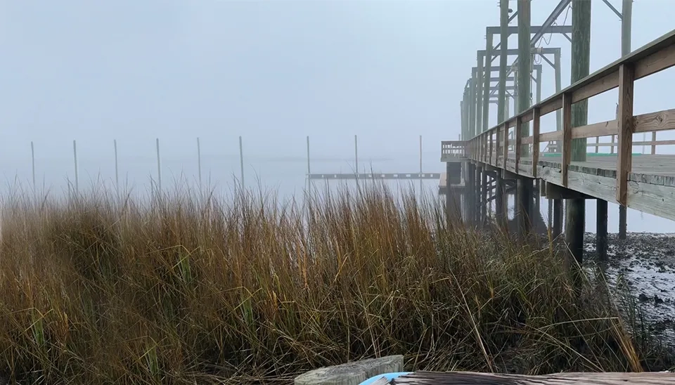
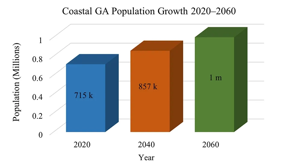
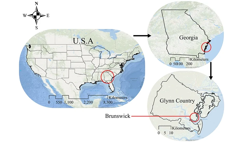
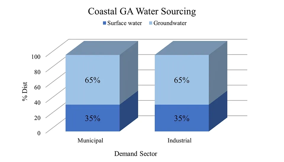
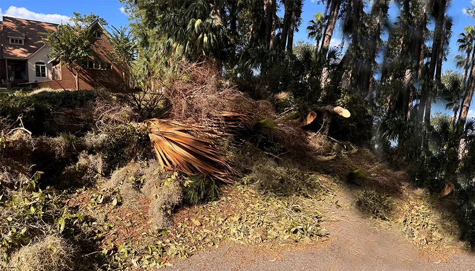
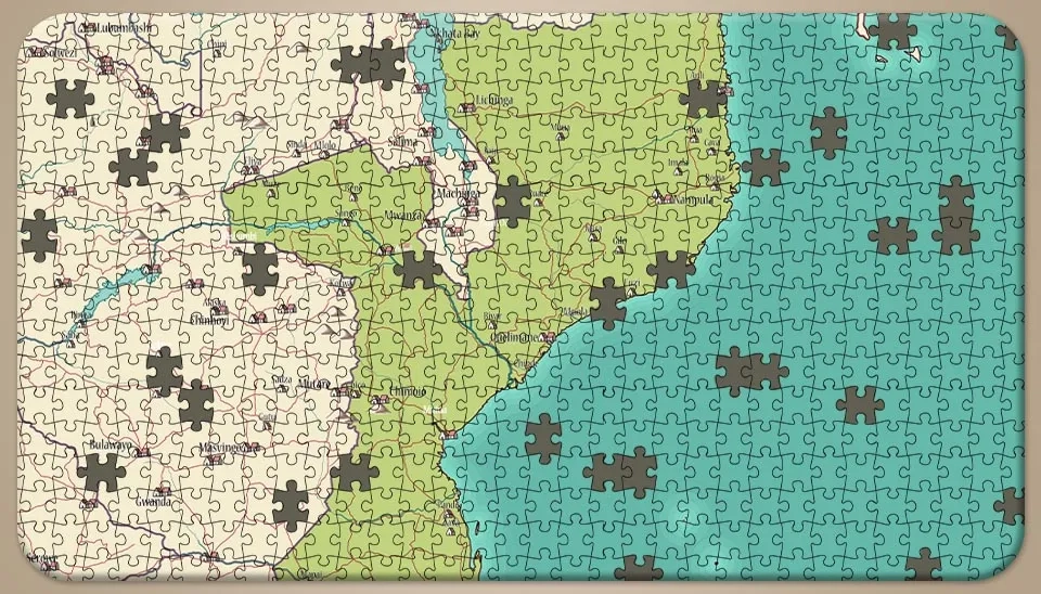
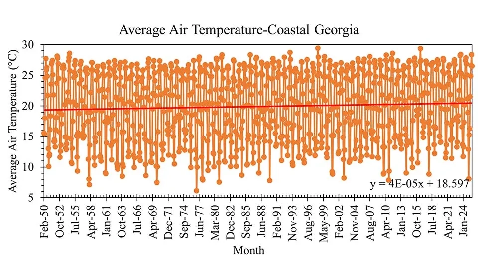
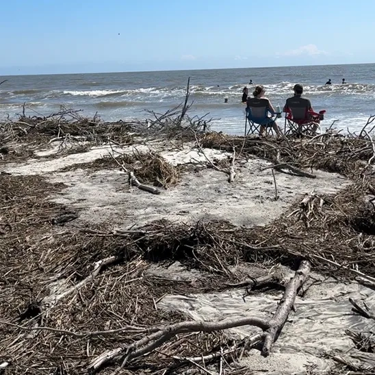
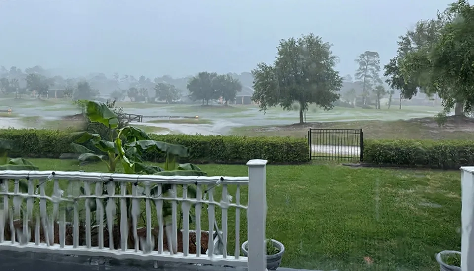
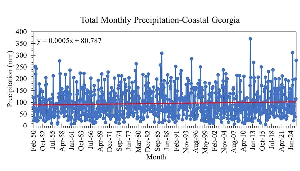
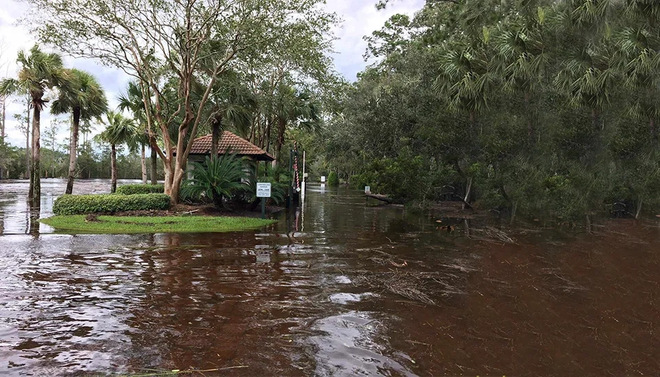
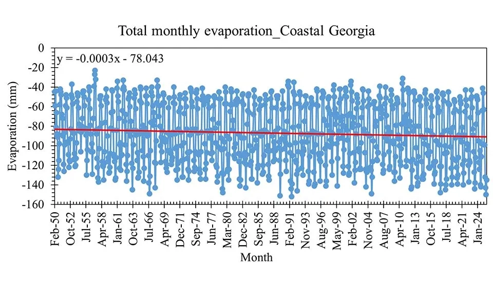
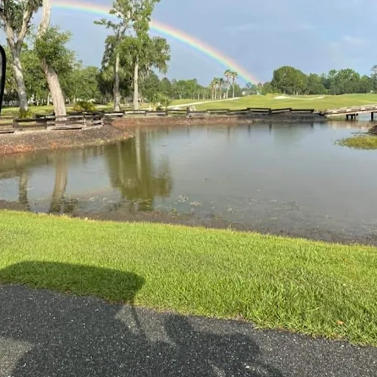
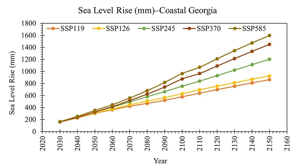

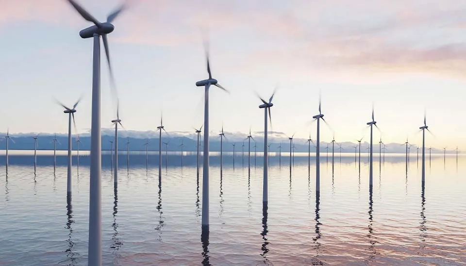
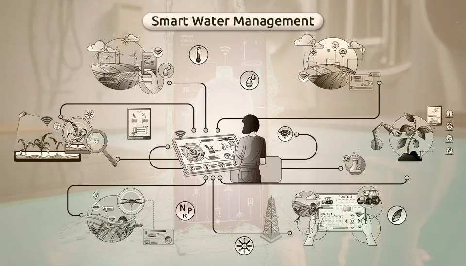
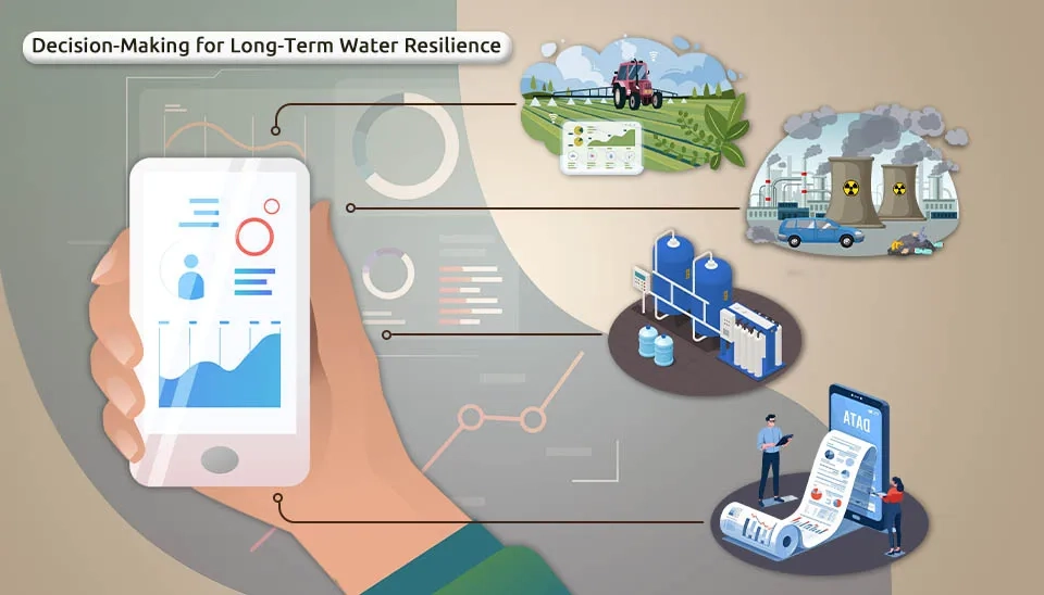
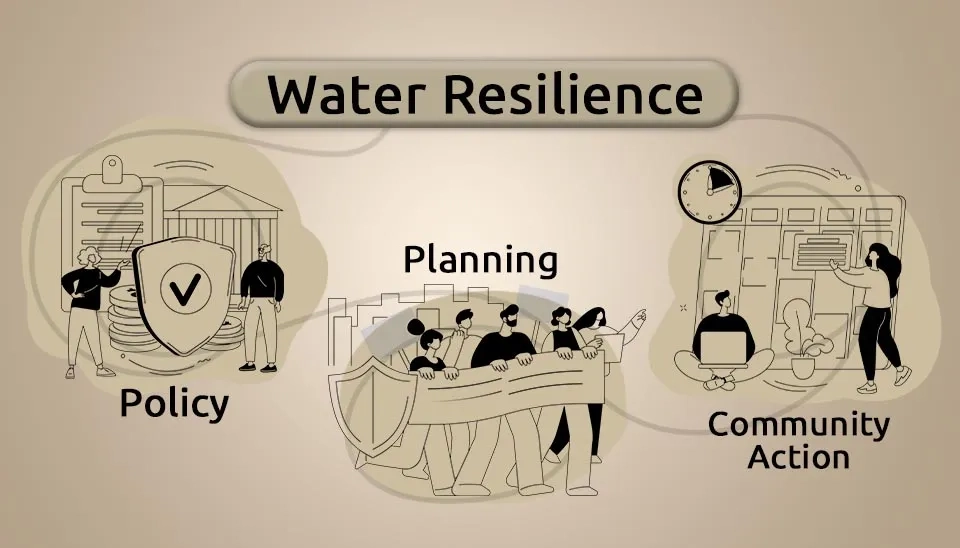
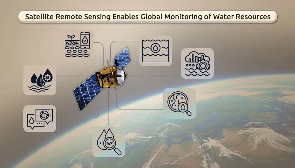


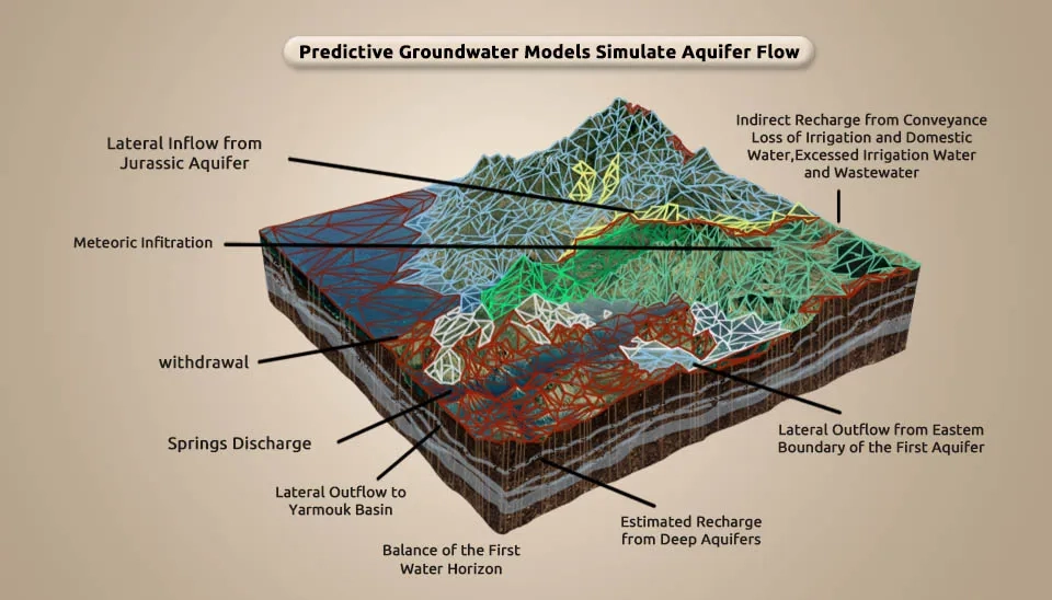
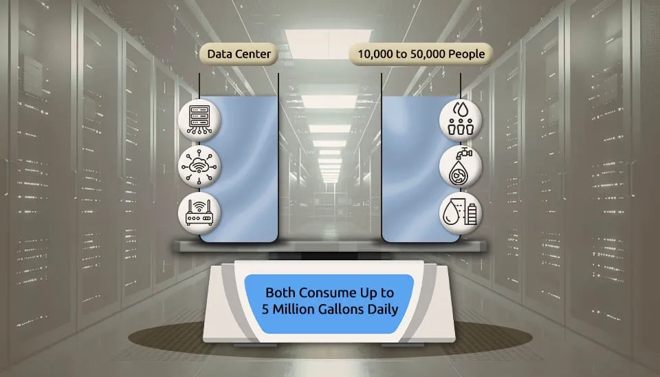

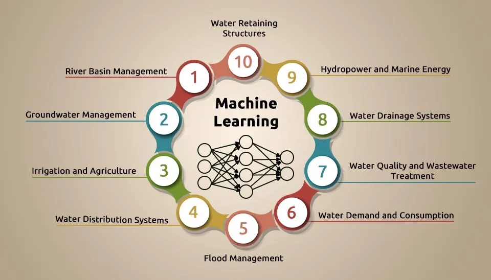
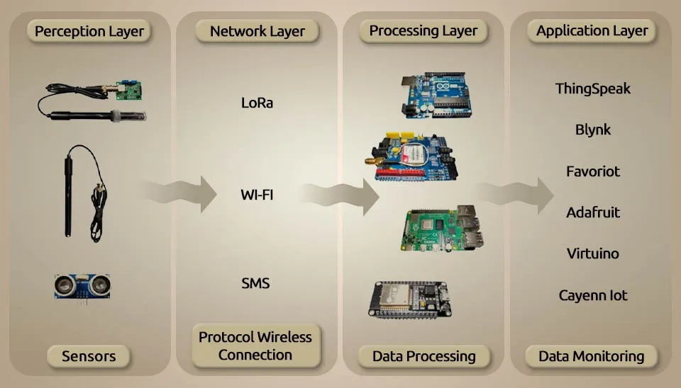
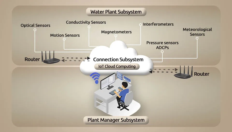
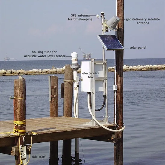
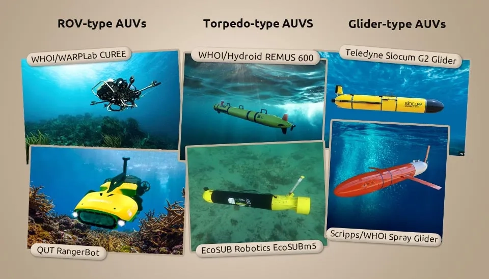
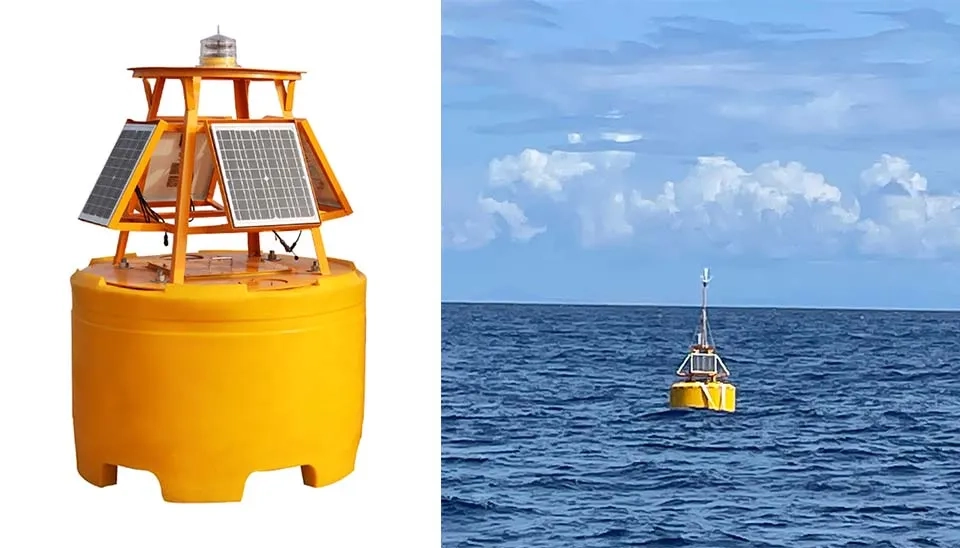
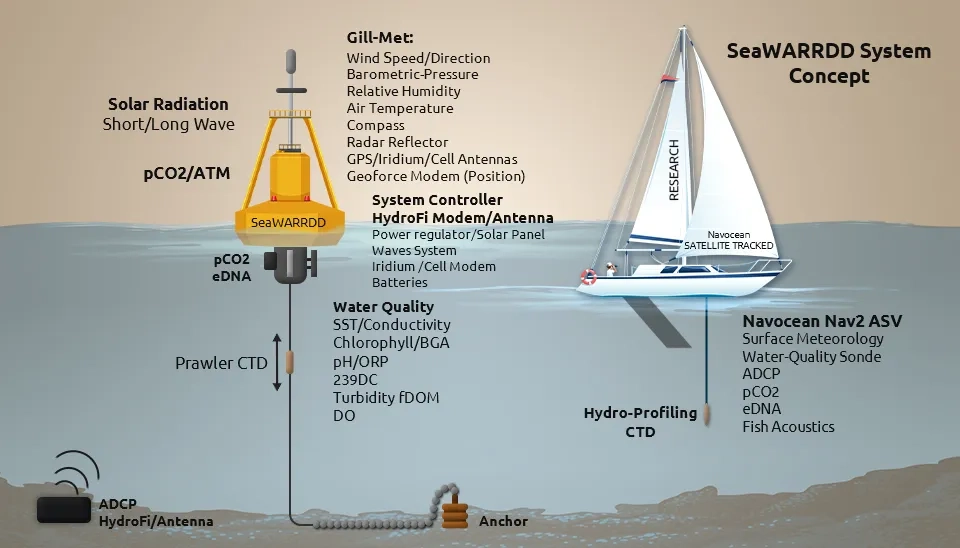
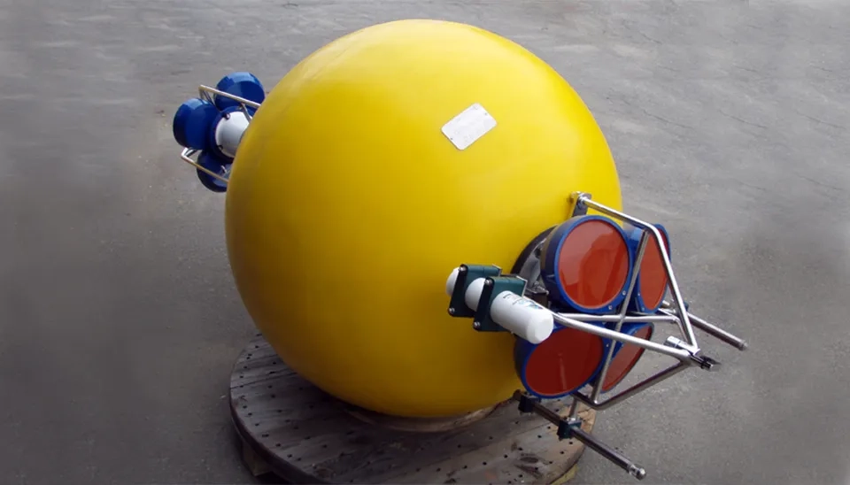
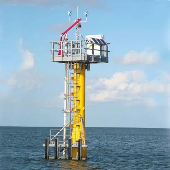
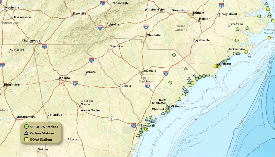
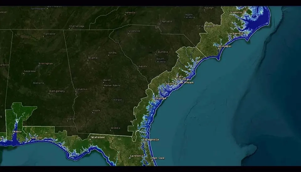
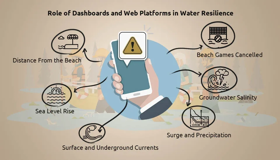
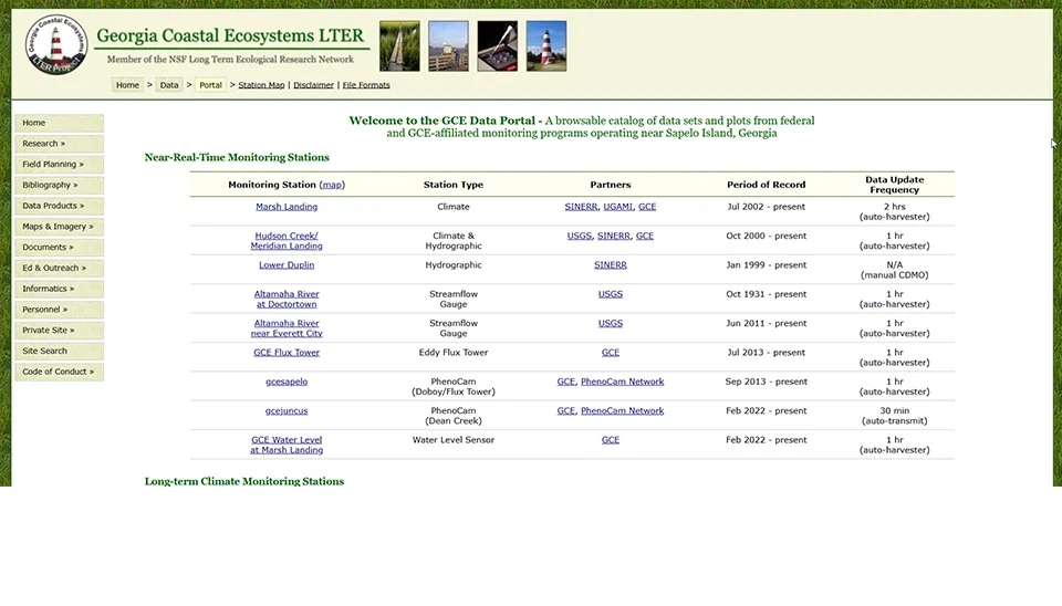

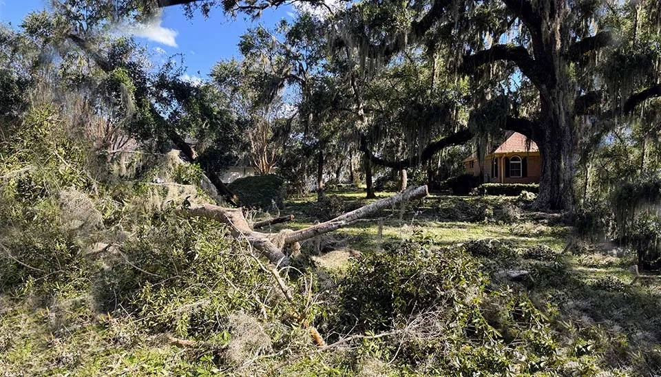
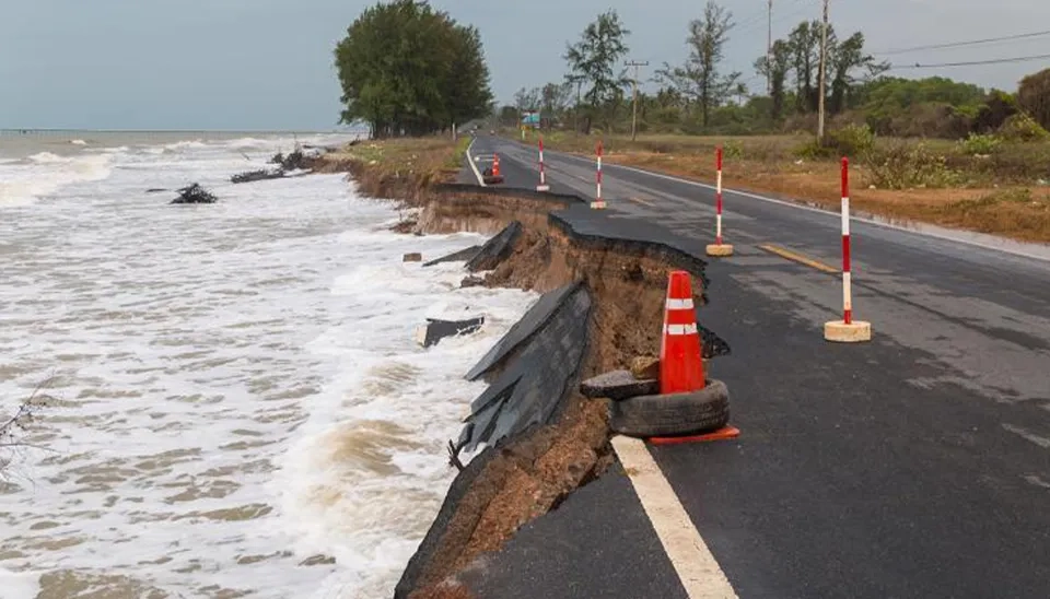
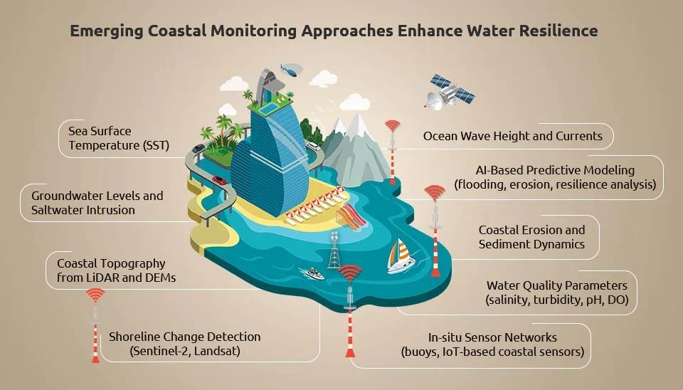
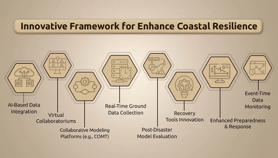
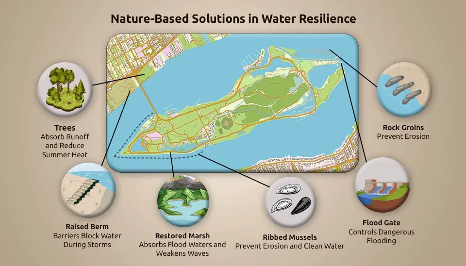
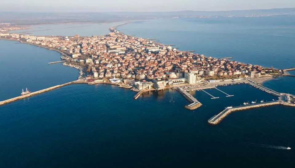


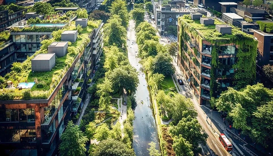
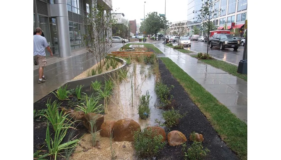
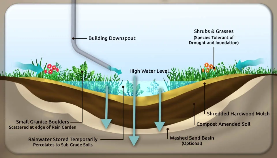
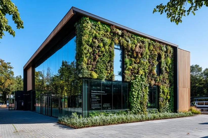
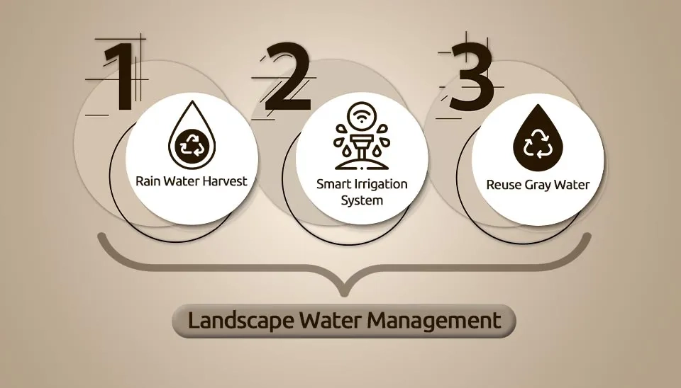
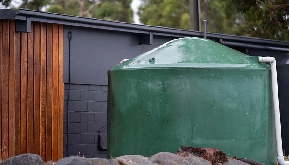
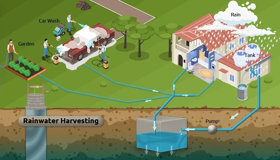

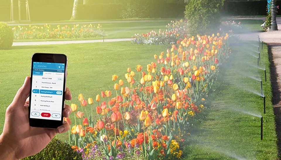
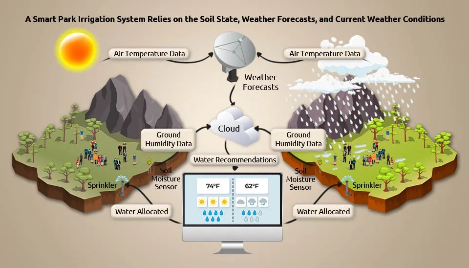


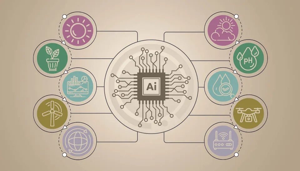


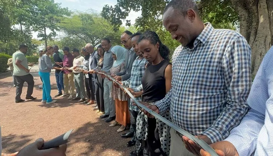
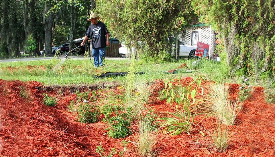

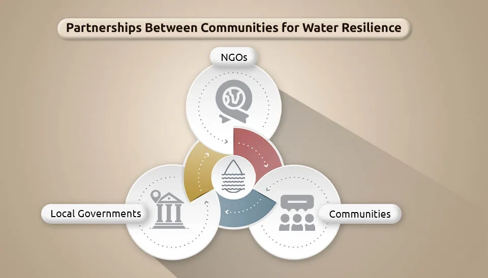
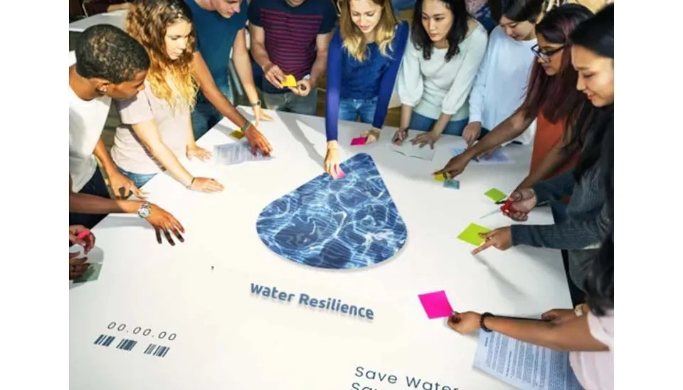

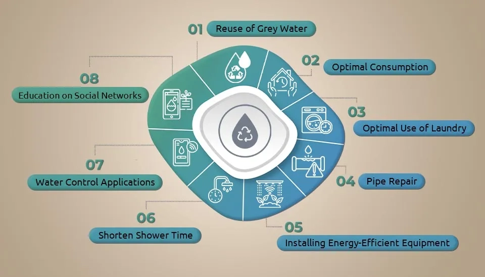
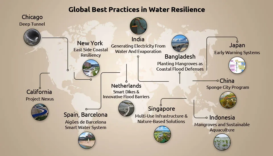

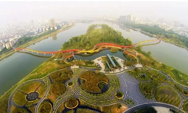
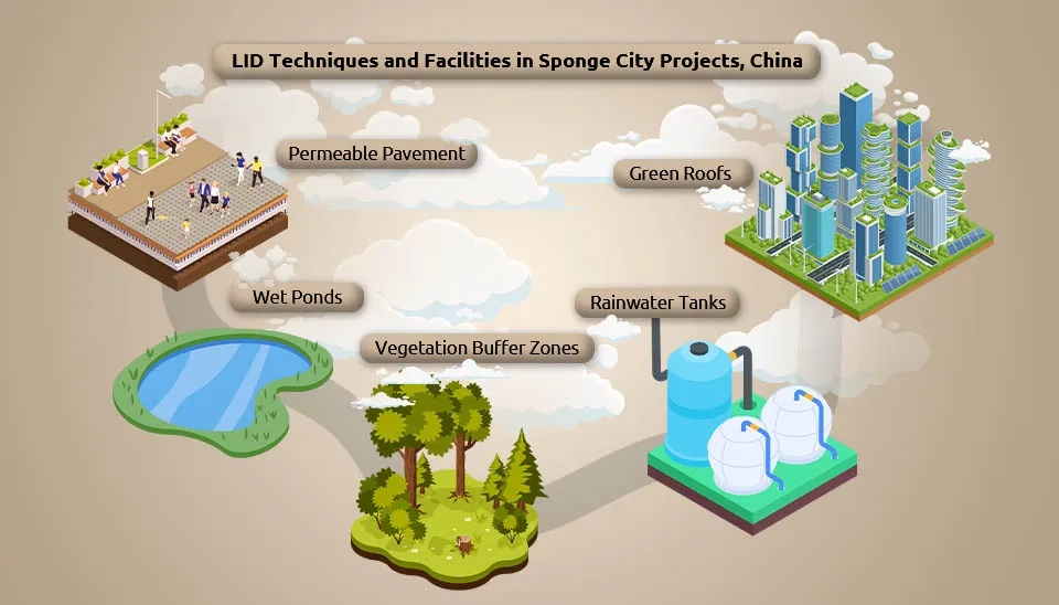
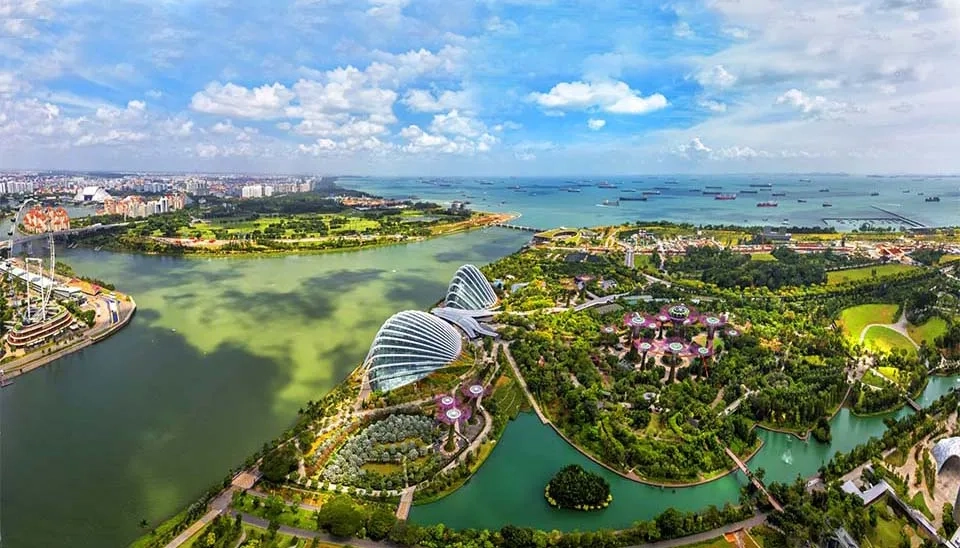


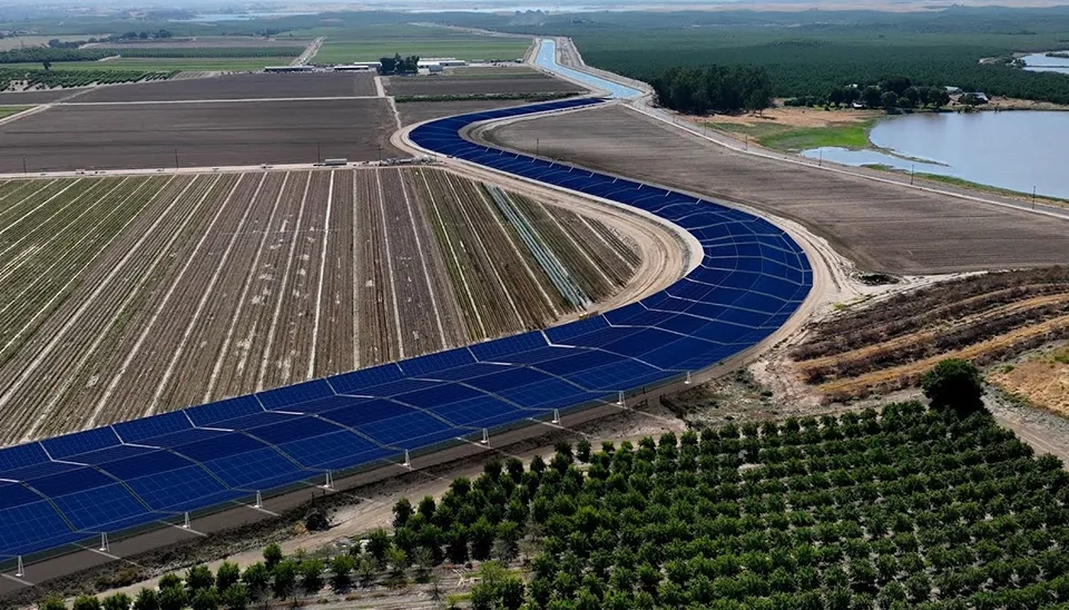
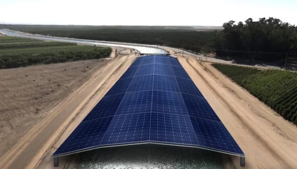
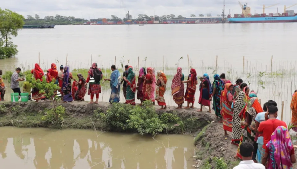
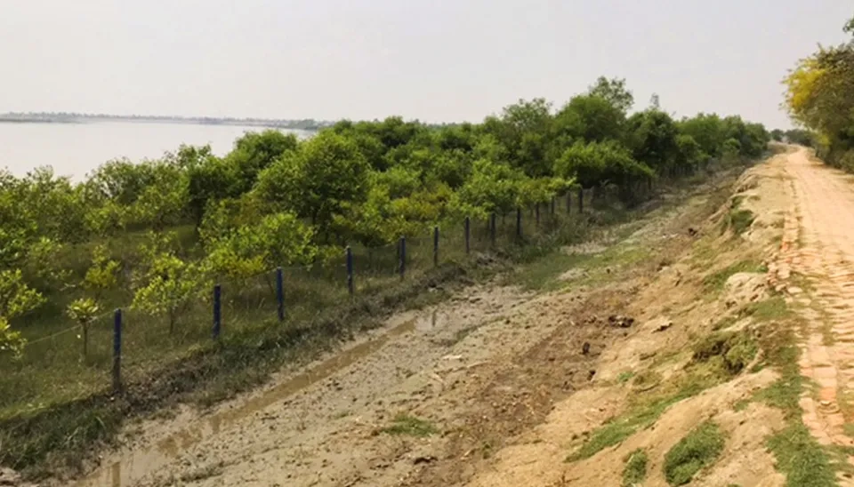
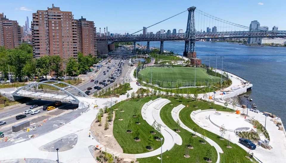
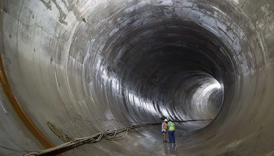
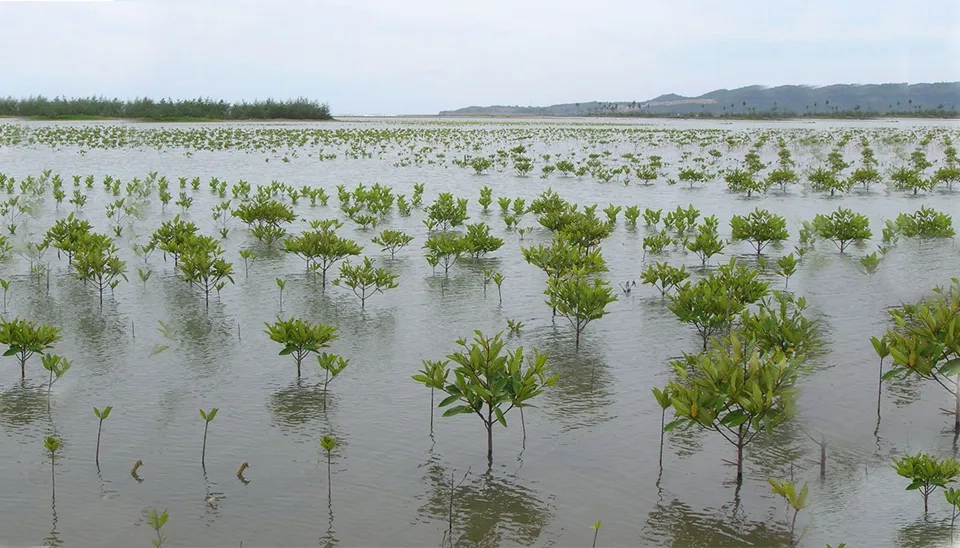
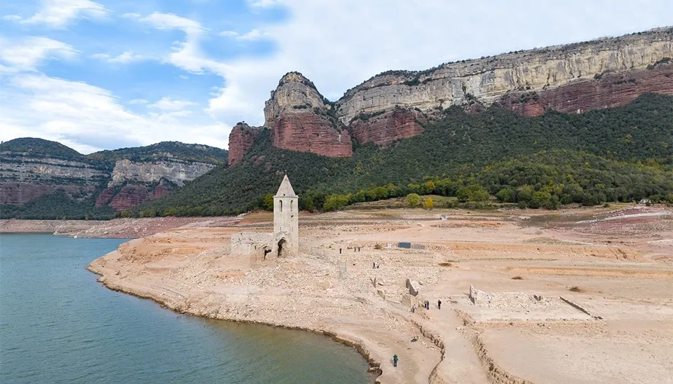
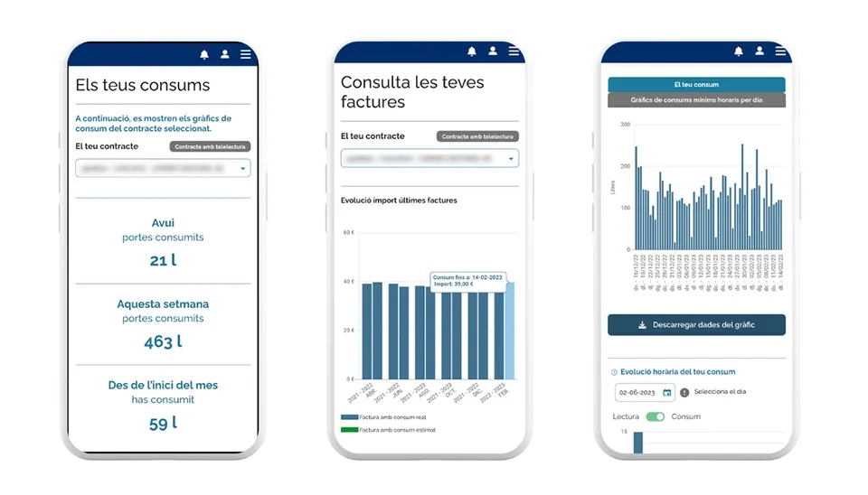

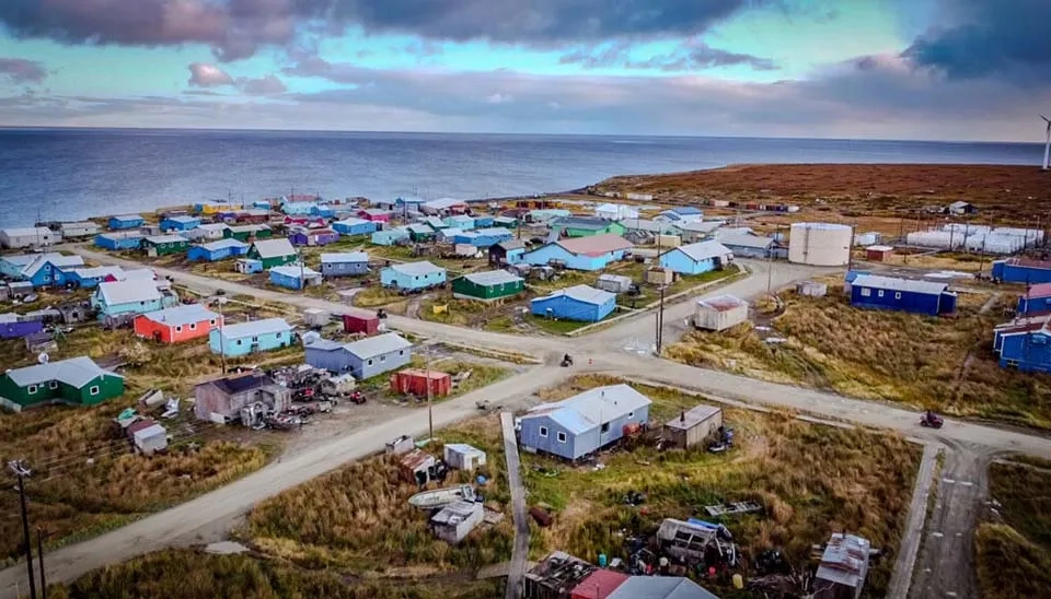
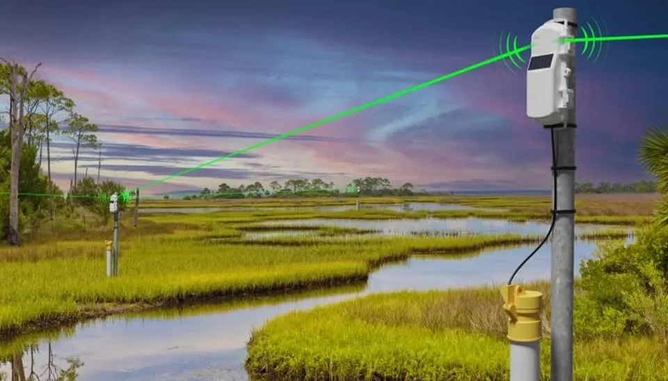

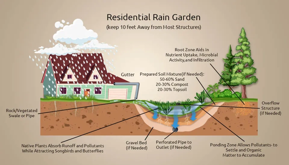


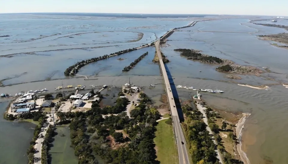


Comments
No comments yet
Be the first to comment
Share your thoughts and start the conversation.